

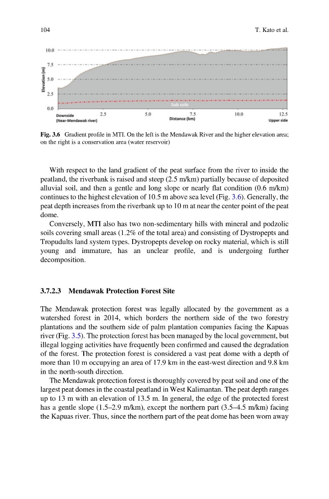
With respect to the land gradient of the peat surface from the river to inside the
peatland, the riverbank is raised and steep (2.5 m/km) partially because of deposited
alluvial soil, and then a gentle and long slope or nearly flat condition (0.6 m/km)
continues to the highest elevation of 10.5 m above sea level (Fig. 3.6). Generally, the
peat depth increases from the riverbank up to 10 m at near the center point of the peat
dome.
Conversely, MTI also has two non-sedimentary hills with mineral and podzolic
soils covering small areas (1.2% of the total area) and consisting of Dystropepts and
Tropudults land system types. Dystropepts develop on rocky material, which is still
young and immature, has an unclear profile, and is undergoing further
decomposition.
3.7.2.3 Mendawak Protection Forest Site
The Mendawak protection forest was legally allocated by the government as a
watershed forest in 2014, which borders the northern side of the two forestry
plantations and the southern side of palm plantation companies facing the Kapuas
river (Fig. 3.5). The protection forest has been managed by the local government, but
illegal logging activities have frequently been confirmed and caused the degradation
of the forest. The protection forest is considered a vast peat dome with a depth of
more than 10 m occupying an area of 17.9 km in the east-west direction and 9.8 km
in the north-south direction.
The Mendawak protection forest is thoroughly covered by peat soil and one of the
largest peat domes in the coastal peatland in West Kalimantan. The peat depth ranges
up to 13 m with an elevation of 13.5 m. In general, the edge of the protected forest
has a gentle slope (1.5–2.9 m/km), except the northern part (3.5–4.5 m/km) facing
the Kapuas river. Thus, since the northern part of the peat dome has been worn away
Fig. 3.6 Gradient profile in MTI. On the left is the Mendawak River and the higher elevation area;
on the right is a conservation area (water reservoir)
104
T. Kato et al.
peatland, the riverbank is raised and steep (2.5 m/km) partially because of deposited
alluvial soil, and then a gentle and long slope or nearly flat condition (0.6 m/km)
continues to the highest elevation of 10.5 m above sea level (Fig. 3.6). Generally, the
peat depth increases from the riverbank up to 10 m at near the center point of the peat
dome.
Conversely, MTI also has two non-sedimentary hills with mineral and podzolic
soils covering small areas (1.2% of the total area) and consisting of Dystropepts and
Tropudults land system types. Dystropepts develop on rocky material, which is still
young and immature, has an unclear profile, and is undergoing further
decomposition.
3.7.2.3 Mendawak Protection Forest Site
The Mendawak protection forest was legally allocated by the government as a
watershed forest in 2014, which borders the northern side of the two forestry
plantations and the southern side of palm plantation companies facing the Kapuas
river (Fig. 3.5). The protection forest has been managed by the local government, but
illegal logging activities have frequently been confirmed and caused the degradation
of the forest. The protection forest is considered a vast peat dome with a depth of
more than 10 m occupying an area of 17.9 km in the east-west direction and 9.8 km
in the north-south direction.
The Mendawak protection forest is thoroughly covered by peat soil and one of the
largest peat domes in the coastal peatland in West Kalimantan. The peat depth ranges
up to 13 m with an elevation of 13.5 m. In general, the edge of the protected forest
has a gentle slope (1.5–2.9 m/km), except the northern part (3.5–4.5 m/km) facing
the Kapuas river. Thus, since the northern part of the peat dome has been worn away
Fig. 3.6 Gradient profile in MTI. On the left is the Mendawak River and the higher elevation area;
on the right is a conservation area (water reservoir)
104
T. Kato et al.