

229
The latter F is a functional of the topography, free surface gradient, and free
surface itself, as well as the vertical distribution of density and its gradient, and is
expressed as
=
∇
∇ ( ) ( )
x
x
z
z
ζ ζ
ρ
ρ
, ,
,
(12.9)
Thus, the mathematical analysis suggests that water reserve on earth is quite
scary to meet the total water demand in the near future which is generated by the
simple relationships of S(σ) and the independent coordinates involving a full threedimensional (3D) transformation water sources on earth described as
z
z
x y
k
N
k
k
+
+
=
( ) = …
1
2
1
2
0 1
, ,
, , ,
(12.10)
Here, if the water is at rest, the surface water elevation is ζ = 0; hence z N+1/2 = 0,
and the whole set corresponding to zero surface water {z
(0) k+1/2 } is referred to as an
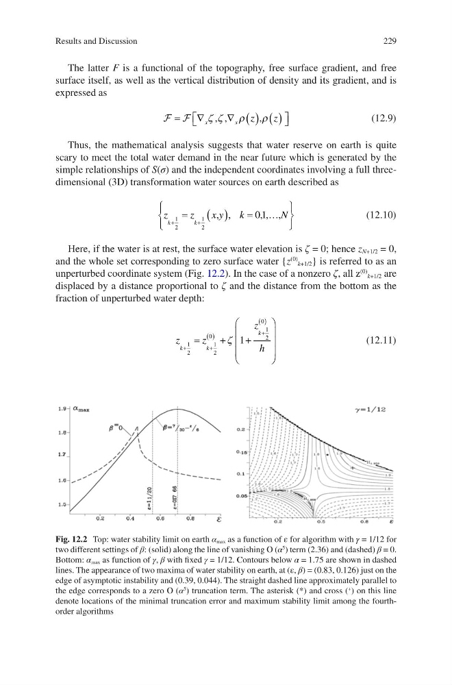
unperturbed coordinate system (Fig. 12.2). In the case of a nonzero ζ, all z
(0) k+1/2 are
displaced by a distance proportional to ζ and the distance from the bottom as the
fraction of unperturbed water depth:
z
z
z
h
k
k
k
+
+
( )
+
( )
=
+
+
1
2
1
2
0
1
2
0
1
ζ
(12.11)
Fig. 12.2 Top: water stability limit on earth α max as a function of ε for algorithm with γ = 1/12 for
two different settings of β: (solid) along the line of vanishing O (α
5 ) term (2.36) and (dashed) β = 0.
Bottom: α max as function of γ, β with fixed γ = 1/12. Contours below α = 1.75 are shown in dashed
lines. The appearance of two maxima of water stability on earth, at (ε, β) = (0.83, 0.126) just on the
edge of asymptotic instability and (0.39, 0.044). The straight dashed line approximately parallel to
the edge corresponds to a zero O (α
5 ) truncation term. The asterisk (*) and cross (
+
) on this line
denote locations of the minimal truncation error and maximum stability limit among the fourthorder algorithms
Results and Discussion
The latter F is a functional of the topography, free surface gradient, and free
surface itself, as well as the vertical distribution of density and its gradient, and is
expressed as
=
∇
∇ ( ) ( )
x
x
z
z
ζ ζ
ρ
ρ
, ,
,
(12.9)
Thus, the mathematical analysis suggests that water reserve on earth is quite
scary to meet the total water demand in the near future which is generated by the
simple relationships of S(σ) and the independent coordinates involving a full threedimensional (3D) transformation water sources on earth described as
z
z
x y
k
N
k
k
+
+
=
( ) = …
1
2
1
2
0 1
, ,
, , ,
(12.10)
Here, if the water is at rest, the surface water elevation is ζ = 0; hence z N+1/2 = 0,
and the whole set corresponding to zero surface water {z
(0) k+1/2 } is referred to as an
unperturbed coordinate system (Fig. 12.2). In the case of a nonzero ζ, all z
(0) k+1/2 are
displaced by a distance proportional to ζ and the distance from the bottom as the
fraction of unperturbed water depth:
z
z
z
h
k
k
k
+
+
( )
+
( )
=
+
+
1
2
1
2
0
1
2
0
1
ζ
(12.11)
Fig. 12.2 Top: water stability limit on earth α max as a function of ε for algorithm with γ = 1/12 for
two different settings of β: (solid) along the line of vanishing O (α
5 ) term (2.36) and (dashed) β = 0.
Bottom: α max as function of γ, β with fixed γ = 1/12. Contours below α = 1.75 are shown in dashed
lines. The appearance of two maxima of water stability on earth, at (ε, β) = (0.83, 0.126) just on the
edge of asymptotic instability and (0.39, 0.044). The straight dashed line approximately parallel to
the edge corresponds to a zero O (α
5 ) truncation term. The asterisk (*) and cross (
+
) on this line
denote locations of the minimal truncation error and maximum stability limit among the fourthorder algorithms
Results and Discussion