

227
z z x y
= (
)
, ,σ
(12.1)
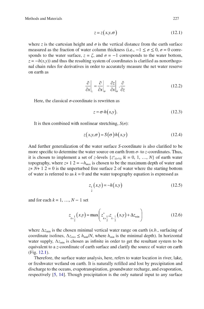
where z is the cartesian height and σ is the vertical distance from the earth surface
measured as the fraction of water column thickness (i.e., −1 ≤ σ ≤ 0, σ = 0 corresponds to the water surface, z = ζ, and σ = −1 corresponds to the water bottom,
z = −h(x,y)) and thus the resulting system of coordinates is clarified as nonorthogonal chain rules for derivatives in order to accurately measure the net water reserve
on earth as
∂
∂
=
∂
∂
−
∂
∂
∂
∂
x
x
z
x
z
z
σ
σ
.
(12.2)
Here, the classical σ-coordinate is rewritten as
z
h x y
=
( )
σ ·
.
,
(12.3)
It is then combined with nonlinear stretching, S(σ):
z x y
S
h x y
, ,
,
σ
σ
(
)= ( ) ( )
·
(12.4)
And further generalization of the water surface S-coordinate is also clarified to be
more specific to determine the water source on earth from σ- to z-coordinates. Thus,
it is chosen to implement a set of z-levels {z
∗ (k+½) |k = 0, 1, …, N} of earth water
topography, where z∗ 1 2 = −h max is chosen to be the maximum depth of water and
z∗ N+ 1 2 = 0 is the unperturbed free surface 2 of water where the starting bottom
of water is referred to as k = 0 and the water topography equation is expressed as
z x y
h x y
1
2
,
,
( )= − ( )
(12.5)
and for each k = 1, …, N − 1 set
z
xy
z z
xy
z
k
k
k
+
+
∗
−
( )=
( )+
1
2
1
2
1
2
,
,
,
max
min
∆
(12.6)
where ∆z min is the chosen minimal vertical water range on earth (n.b., surfacing of
coordinate isolines, ∆z min ≤ h min /N, where h min is the minimal depth). In horizontal
water supply, ∆z min is chosen as infinite in order to get the resultant system to be
equivalent to a z-coordinate of earth surface and clarify the source of water on earth
(Fig. 12.1).
Therefore, the surface water analysis, here, refers to water location in river, lake,
or freshwater wetland on earth. It is naturally refilled and lost by precipitation and
discharge to the oceans, evapotranspiration, groundwater recharge, and evaporation,
respectively [5, 14]. Though precipitation is the only natural input to any surface
Methods and Materials
z z x y
= (
)
, ,σ
(12.1)
where z is the cartesian height and σ is the vertical distance from the earth surface
measured as the fraction of water column thickness (i.e., −1 ≤ σ ≤ 0, σ = 0 corresponds to the water surface, z = ζ, and σ = −1 corresponds to the water bottom,
z = −h(x,y)) and thus the resulting system of coordinates is clarified as nonorthogonal chain rules for derivatives in order to accurately measure the net water reserve
on earth as
∂
∂
=
∂
∂
−
∂
∂
∂
∂
x
x
z
x
z
z
σ
σ
.
(12.2)
Here, the classical σ-coordinate is rewritten as
z
h x y
=
( )
σ ·
.
,
(12.3)
It is then combined with nonlinear stretching, S(σ):
z x y
S
h x y
, ,
,
σ
σ
(
)= ( ) ( )
·
(12.4)
And further generalization of the water surface S-coordinate is also clarified to be
more specific to determine the water source on earth from σ- to z-coordinates. Thus,
it is chosen to implement a set of z-levels {z
∗ (k+½) |k = 0, 1, …, N} of earth water
topography, where z∗ 1 2 = −h max is chosen to be the maximum depth of water and
z∗ N+ 1 2 = 0 is the unperturbed free surface 2 of water where the starting bottom
of water is referred to as k = 0 and the water topography equation is expressed as
z x y
h x y
1
2
,
,
( )= − ( )
(12.5)
and for each k = 1, …, N − 1 set
z
xy
z z
xy
z
k
k
k
+
+
∗
−
( )=
( )+
1
2
1
2
1
2
,
,
,
max
min
∆
(12.6)
where ∆z min is the chosen minimal vertical water range on earth (n.b., surfacing of
coordinate isolines, ∆z min ≤ h min /N, where h min is the minimal depth). In horizontal
water supply, ∆z min is chosen as infinite in order to get the resultant system to be
equivalent to a z-coordinate of earth surface and clarify the source of water on earth
(Fig. 12.1).
Therefore, the surface water analysis, here, refers to water location in river, lake,
or freshwater wetland on earth. It is naturally refilled and lost by precipitation and
discharge to the oceans, evapotranspiration, groundwater recharge, and evaporation,
respectively [5, 14]. Though precipitation is the only natural input to any surface
Methods and Materials