

318
J. Fac-Beneda et al.
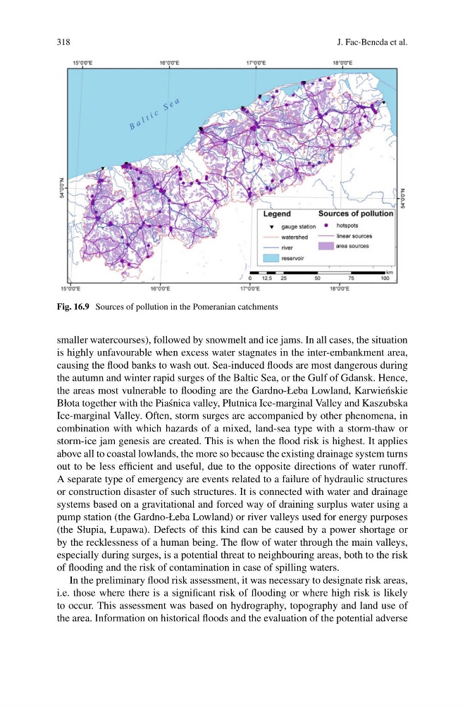
Fig. 16.9 Sources of pollution in the Pomeranian catchments
smaller watercourses), followed by snowmelt and ice jams. In all cases, the situation
is highly unfavourable when excess water stagnates in the inter-embankment area,
causing the flood banks to wash out. Sea-induced floods are most dangerous during
the autumn and winter rapid surges of the Baltic Sea, or the Gulf of Gdansk. Hence,
the areas most vulnerable to flooding are the Gardno-Łeba Lowland, Karwie´ nskie
Błota together with the Pia´ snica valley, Płutnica Ice-marginal Valley and Kaszubska
Ice-marginal Valley. Often, storm surges are accompanied by other phenomena, in
combination with which hazards of a mixed, land-sea type with a storm-thaw or
storm-ice jam genesis are created. This is when the flood risk is highest. It applies
above all to coastal lowlands, the more so because the existing drainage system turns
out to be less efficient and useful, due to the opposite directions of water runoff.
A separate type of emergency are events related to a failure of hydraulic structures
or construction disaster of such structures. It is connected with water and drainage
systems based on a gravitational and forced way of draining surplus water using a
pump station (the Gardno-Łeba Lowland) or river valleys used for energy purposes
(the Słupia, Łupawa). Defects of this kind can be caused by a power shortage or
by the recklessness of a human being. The flow of water through the main valleys,
especially during surges, is a potential threat to neighbouring areas, both to the risk
of flooding and the risk of contamination in case of spilling waters.
In the preliminary flood risk assessment, it was necessary to designate risk areas,
i.e. those where there is a significant risk of flooding or where high risk is likely
to occur. This assessment was based on hydrography, topography and land use of
the area. Information on historical floods and the evaluation of the potential adverse
J. Fac-Beneda et al.
Fig. 16.9 Sources of pollution in the Pomeranian catchments
smaller watercourses), followed by snowmelt and ice jams. In all cases, the situation
is highly unfavourable when excess water stagnates in the inter-embankment area,
causing the flood banks to wash out. Sea-induced floods are most dangerous during
the autumn and winter rapid surges of the Baltic Sea, or the Gulf of Gdansk. Hence,
the areas most vulnerable to flooding are the Gardno-Łeba Lowland, Karwie´ nskie
Błota together with the Pia´ snica valley, Płutnica Ice-marginal Valley and Kaszubska
Ice-marginal Valley. Often, storm surges are accompanied by other phenomena, in
combination with which hazards of a mixed, land-sea type with a storm-thaw or
storm-ice jam genesis are created. This is when the flood risk is highest. It applies
above all to coastal lowlands, the more so because the existing drainage system turns
out to be less efficient and useful, due to the opposite directions of water runoff.
A separate type of emergency are events related to a failure of hydraulic structures
or construction disaster of such structures. It is connected with water and drainage
systems based on a gravitational and forced way of draining surplus water using a
pump station (the Gardno-Łeba Lowland) or river valleys used for energy purposes
(the Słupia, Łupawa). Defects of this kind can be caused by a power shortage or
by the recklessness of a human being. The flow of water through the main valleys,
especially during surges, is a potential threat to neighbouring areas, both to the risk
of flooding and the risk of contamination in case of spilling waters.
In the preliminary flood risk assessment, it was necessary to designate risk areas,
i.e. those where there is a significant risk of flooding or where high risk is likely
to occur. This assessment was based on hydrography, topography and land use of
the area. Information on historical floods and the evaluation of the potential adverse