

16 Water Management in the Pomeranian Rivers Estuary Zone …
319
effects of floods that may occur in the future were taken into account. The effect
of these activities is the forecast of the long-term development of events, in particular, the impact of climate change on the occurrence of floods. In all catchments
discussed, after the year 2000, an increase in the number and location of floods was
registered. These were floods on the Reda (2008, 2009), Pars˛ eta (2002), Grabowa
(2005), Wieprza (2004), Słupia (2001), Łupawa (2007), Łeba (2002) and Reda
(2001). Besides, in 2007 flood occurred on Lake Jamno. At the end of the nineteenth century and the beginning of the twentieth-century floods took place on three
rivers: the Pars˛ eta (1874), Łeba (1898) and Wieprza (1914). The Słupia and Łeba
experienced high water in 1982 and 1998 respectively.
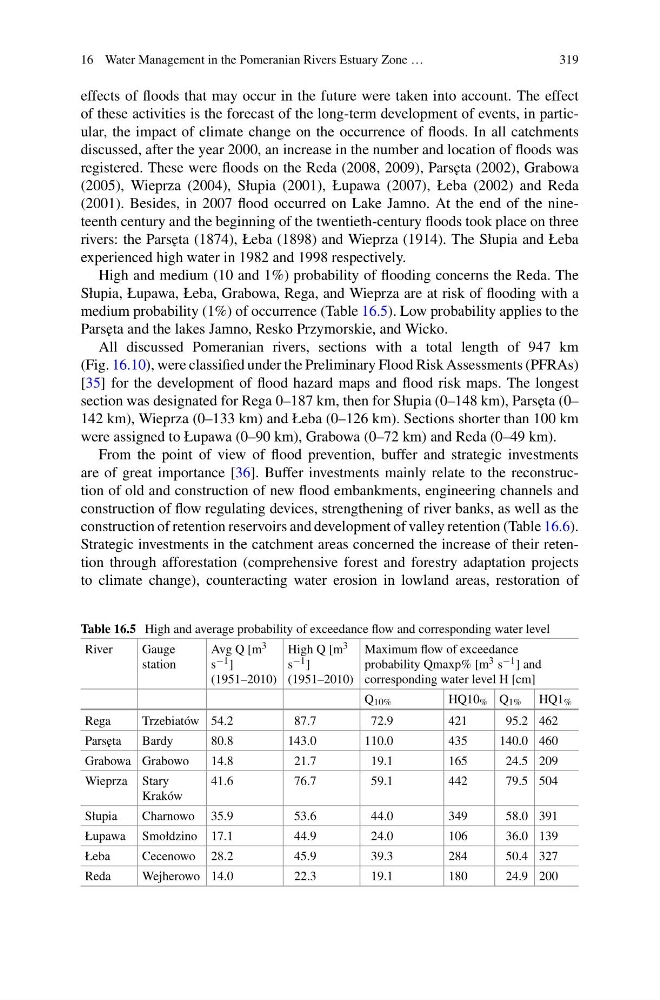
High and medium (10 and 1%) probability of flooding concerns the Reda. The
Słupia, Łupawa, Łeba, Grabowa, Rega, and Wieprza are at risk of flooding with a
medium probability (1%) of occurrence (Table 16.5). Low probability applies to the
Pars˛ eta and the lakes Jamno, Resko Przymorskie, and Wicko.
All discussed Pomeranian rivers, sections with a total length of 947 km
(Fig. 16.10), were classified under the Preliminary Flood Risk Assessments (PFRAs)
[35] for the development of flood hazard maps and flood risk maps. The longest
section was designated for Rega 0–187 km, then for Słupia (0–148 km), Pars˛ eta (0–
142 km), Wieprza (0–133 km) and Łeba (0–126 km). Sections shorter than 100 km
were assigned to Łupawa (0–90 km), Grabowa (0–72 km) and Reda (0–49 km).
From the point of view of flood prevention, buffer and strategic investments
are of great importance [36]. Buffer investments mainly relate to the reconstruction of old and construction of new flood embankments, engineering channels and
construction of flow regulating devices, strengthening of river banks, as well as the
construction of retention reservoirs and development of valley retention (Table 16.6).
Strategic investments in the catchment areas concerned the increase of their retention through afforestation (comprehensive forest and forestry adaptation projects
to climate change), counteracting water erosion in lowland areas, restoration of
Table 16.5 High and average probability of exceedance flow and corresponding water level
River
Gauge
station
Avg Q [m 3
s −1 ]
(1951–2010)
High Q [m 3
s −1 ]
(1951–2010)
Maximum flow of exceedance
probability Qmaxp% [m 3 s −1 ] and
corresponding water level H [cm]
Q 10%
HQ10 % Q 1% HQ1 %
Rega
Trzebiatów 54.2
87.7
72.9
421
95.2 462
Pars˛ eta
Bardy
80.8
143.0
110.0
435
140.0 460
Grabowa Grabowo
14.8
21.7
19.1
165
24.5 209
Wieprza Stary
Kraków
41.6
76.7
59.1
442
79.5 504
Słupia
Charnowo 35.9
53.6
44.0
349
58.0 391
Łupawa Smołdzino 17.1
44.9
24.0
106
36.0 139
Łeba
Cecenowo 28.2
45.9
39.3
284
50.4 327
Reda
Wejherowo 14.0
22.3
19.1
180
24.9 200
319
effects of floods that may occur in the future were taken into account. The effect
of these activities is the forecast of the long-term development of events, in particular, the impact of climate change on the occurrence of floods. In all catchments
discussed, after the year 2000, an increase in the number and location of floods was
registered. These were floods on the Reda (2008, 2009), Pars˛ eta (2002), Grabowa
(2005), Wieprza (2004), Słupia (2001), Łupawa (2007), Łeba (2002) and Reda
(2001). Besides, in 2007 flood occurred on Lake Jamno. At the end of the nineteenth century and the beginning of the twentieth-century floods took place on three
rivers: the Pars˛ eta (1874), Łeba (1898) and Wieprza (1914). The Słupia and Łeba
experienced high water in 1982 and 1998 respectively.
High and medium (10 and 1%) probability of flooding concerns the Reda. The
Słupia, Łupawa, Łeba, Grabowa, Rega, and Wieprza are at risk of flooding with a
medium probability (1%) of occurrence (Table 16.5). Low probability applies to the
Pars˛ eta and the lakes Jamno, Resko Przymorskie, and Wicko.
All discussed Pomeranian rivers, sections with a total length of 947 km
(Fig. 16.10), were classified under the Preliminary Flood Risk Assessments (PFRAs)
[35] for the development of flood hazard maps and flood risk maps. The longest
section was designated for Rega 0–187 km, then for Słupia (0–148 km), Pars˛ eta (0–
142 km), Wieprza (0–133 km) and Łeba (0–126 km). Sections shorter than 100 km
were assigned to Łupawa (0–90 km), Grabowa (0–72 km) and Reda (0–49 km).
From the point of view of flood prevention, buffer and strategic investments
are of great importance [36]. Buffer investments mainly relate to the reconstruction of old and construction of new flood embankments, engineering channels and
construction of flow regulating devices, strengthening of river banks, as well as the
construction of retention reservoirs and development of valley retention (Table 16.6).
Strategic investments in the catchment areas concerned the increase of their retention through afforestation (comprehensive forest and forestry adaptation projects
to climate change), counteracting water erosion in lowland areas, restoration of
Table 16.5 High and average probability of exceedance flow and corresponding water level
River
Gauge
station
Avg Q [m 3
s −1 ]
(1951–2010)
High Q [m 3
s −1 ]
(1951–2010)
Maximum flow of exceedance
probability Qmaxp% [m 3 s −1 ] and
corresponding water level H [cm]
Q 10%
HQ10 % Q 1% HQ1 %
Rega
Trzebiatów 54.2
87.7
72.9
421
95.2 462
Pars˛ eta
Bardy
80.8
143.0
110.0
435
140.0 460
Grabowa Grabowo
14.8
21.7
19.1
165
24.5 209
Wieprza Stary
Kraków
41.6
76.7
59.1
442
79.5 504
Słupia
Charnowo 35.9
53.6
44.0
349
58.0 391
Łupawa Smołdzino 17.1
44.9
24.0
106
36.0 139
Łeba
Cecenowo 28.2
45.9
39.3
284
50.4 327
Reda
Wejherowo 14.0
22.3
19.1
180
24.9 200