

period. This comparison is based on the digitalized land-use data of the JAVA
1:50,000 map, which was surveyed by the Bureau of Land Surveys in the Dutch
colonial government between 1900 and 1942 and represents the state of Jakarta in
the 1930s. This map has detailed land-use categories, including “kampung
(kampoeng)” and “sparsely inhabited area” (schaars bewoonde streken), in addition
to categories such as “paddy field” and “farmland” (Mimura and Matsuda 2014). It is
assumed that the sparsely inhabited area was also a residential area that housed
indigenous people, although its density was probably less than the density of the
kampung. These two land-use categories, “kampung” and “sparsely inhabited area,”
are assumed to have encompassed residential areas where indigenous communities
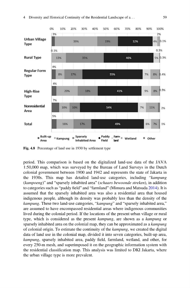
lived during the colonial period. If the locations of the present urban village or rural
type, which is considered as the present kampung, are shown as a kampung or
sparsely inhabited area on the colonial map, they can be approximated as a kampung
of colonial origin. To estimate the continuity of the kampung, we created the digital
data of land use in the colonial map, divided it into seven categories, built-up area,
kampung, sparsely inhabited area, paddy field, farmland, wetland, and other, for
every 250-m mesh, and superimposed it on the geographic information system with
the residential classification map. This analysis was limited to DKI Jakarta, where
the urban village type is more prevalent.
Fig. 4.8 Percentage of land use in 1930 by settlement type
4 Diversity and Historical Continuity of the Residential Landscape of a. . .
59
1:50,000 map, which was surveyed by the Bureau of Land Surveys in the Dutch
colonial government between 1900 and 1942 and represents the state of Jakarta in
the 1930s. This map has detailed land-use categories, including “kampung
(kampoeng)” and “sparsely inhabited area” (schaars bewoonde streken), in addition
to categories such as “paddy field” and “farmland” (Mimura and Matsuda 2014). It is
assumed that the sparsely inhabited area was also a residential area that housed
indigenous people, although its density was probably less than the density of the
kampung. These two land-use categories, “kampung” and “sparsely inhabited area,”
are assumed to have encompassed residential areas where indigenous communities
lived during the colonial period. If the locations of the present urban village or rural
type, which is considered as the present kampung, are shown as a kampung or
sparsely inhabited area on the colonial map, they can be approximated as a kampung
of colonial origin. To estimate the continuity of the kampung, we created the digital
data of land use in the colonial map, divided it into seven categories, built-up area,
kampung, sparsely inhabited area, paddy field, farmland, wetland, and other, for
every 250-m mesh, and superimposed it on the geographic information system with
the residential classification map. This analysis was limited to DKI Jakarta, where
the urban village type is more prevalent.
Fig. 4.8 Percentage of land use in 1930 by settlement type
4 Diversity and Historical Continuity of the Residential Landscape of a. . .
59