

Figure 4.8 shows the land-use category of the 1930s map to which the location of
the current residential type belongs. For the urban village type, the most common
land use in the 1930s was kampung (39%), followed by paddy fields (32%) and
sparsely inhabited areas (19%). The total percentage of kampungs and sparsely
inhabited areas was approximately 60%. This figure represents the percentage of
the urban village type where an indigenous settlement existed during the colonial
period. Therefore, the urban village type of colonial origin is more dominant than
the urban village type created after independence. The same trend is observed for the
rural type, as well. Although paddy fields are the most common category (46%), the
sum of the rural type that was a sparsely inhabited area (35%) and kampung (13%) is
nearly half of the total rural type. Since the urban village type and rural type could be
approximate to kampung, we conclude that nearly half of the currently existing
kampungs originated during the colonial period. Jakarta continues to retain many
historical kampungs that have continued without significant urban development for
nearly 100 years. Their number is estimated to be almost half the number of existing
kampungs and comprises nearly a quarter of the total residential landscape. The
colonial kampung has played a significant role as one of the absorbers of population
growth in the post-war period.
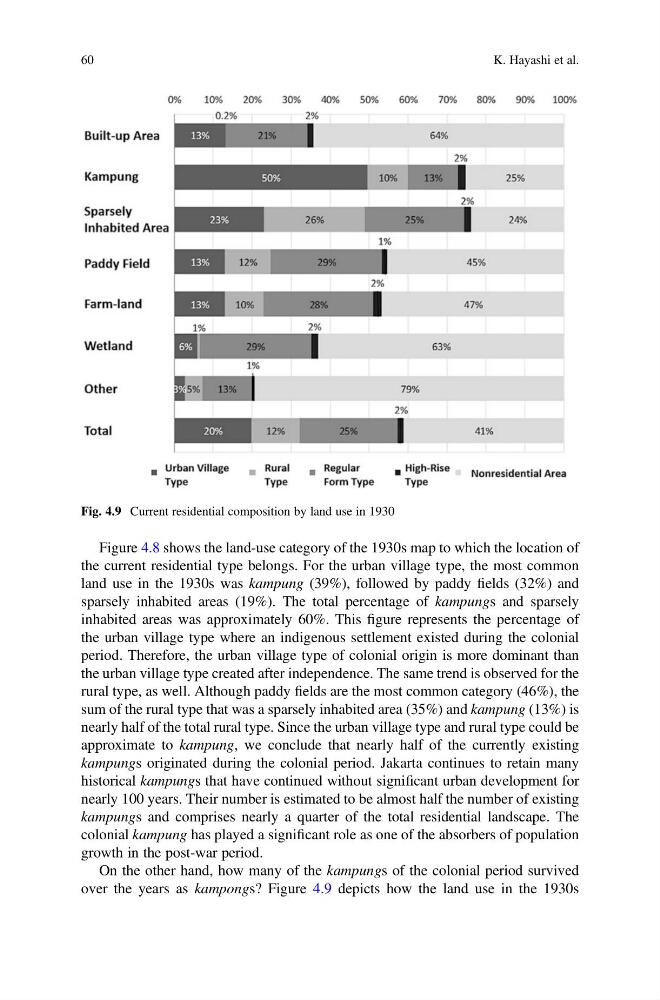
On the other hand, how many of the kampungs of the colonial period survived
over the years as kampongs? Figure 4.9 depicts how the land use in the 1930s
Fig. 4.9 Current residential composition by land use in 1930
60
K. Hayashi et al.
the current residential type belongs. For the urban village type, the most common
land use in the 1930s was kampung (39%), followed by paddy fields (32%) and
sparsely inhabited areas (19%). The total percentage of kampungs and sparsely
inhabited areas was approximately 60%. This figure represents the percentage of
the urban village type where an indigenous settlement existed during the colonial
period. Therefore, the urban village type of colonial origin is more dominant than
the urban village type created after independence. The same trend is observed for the
rural type, as well. Although paddy fields are the most common category (46%), the
sum of the rural type that was a sparsely inhabited area (35%) and kampung (13%) is
nearly half of the total rural type. Since the urban village type and rural type could be
approximate to kampung, we conclude that nearly half of the currently existing
kampungs originated during the colonial period. Jakarta continues to retain many
historical kampungs that have continued without significant urban development for
nearly 100 years. Their number is estimated to be almost half the number of existing
kampungs and comprises nearly a quarter of the total residential landscape. The
colonial kampung has played a significant role as one of the absorbers of population
growth in the post-war period.
On the other hand, how many of the kampungs of the colonial period survived
over the years as kampongs? Figure 4.9 depicts how the land use in the 1930s
Fig. 4.9 Current residential composition by land use in 1930
60
K. Hayashi et al.