

299
17.7 Profile of Sample Villages
17.7.1 Type 1: Undulating Uplands Without Scrub –
Geruapahari Village
This sample site is roughly rectangular in shape, situated in the fringe areas of
Chotanagpur Plateau having an elevation of 100–135 m from mean sea level. A
small ephemeral stream, namely, Mara Jhor, has gone through the area from west
to eastward. Several nullah have originated from the uplands of both north and
south and have joined with the stream. It is predominantly covered by two types of
wastelands, scrub and without scrub due to infertile soil and poor groundwater
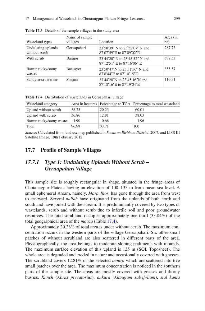
resources. The total scrubland occupies approximately one third (33.04%) of the
total geographical area of the mouza (Table 17.4).
Approximately 20.23% of total area is under without scrub. The maximum concentration occurs in the western parts of the village Geruapahari. Six other small
patches of without scrubland are also scattered in different parts of the area.
Physiographically, the area belongs to moderate sloping pediments with mounds.
The maximum surface elevation of this upland is 135 m (SOI, Toposheet). The
whole area is degraded and eroded in nature and occasionally covered with grasses.
The scrubland covers 12.81% of the selected mouza which are scattered into five
small patches over the area. The maximum concentration is noticed in the southern
parts of the sample site. The areas are mostly covered with grasses and thorny
bushes. Kunch (Abrus precatorius), ankura (Alangium salvifolium), sial kanta
Table 17.3 Details of the sample villages in the study area
Wasteland types
Name of sample
villages
Location
Area (in
ha)
Undulating uplands
without scrub
Geruapahari
23
° 50′39″ N to 23
°
52′07″ N and
87
° 07′59″E to 87
°
09′02″E
287.73
With scrub
Barajor
23
°
44′20″ N to 23
°
45′52″ N and
87
° 12′51″ E to 87
°
16′06″ E
598.53
Barren rocky/stony
wastes
Bansayer
23
°
50′47″N to 23
°
51′56″ N and
87
° 8′44″E to 87
°
10′15″E
355.57
Sandy area-riverine
Simjuri
23
°
44′28″N to 23
°
45′16″N and
87
° 18′16″E to 87
°
19′04″E
110.31
Table 17.4 Distribution of wastelands in Geruapahari village
Wasteland category
Area in hectares Percentage to TGA Percentage to total wasteland
Upland without scrub
58.23
20.23
60.01
Upland with scrub
36.86
12.81
38.03
Barren rocky/stony wastes 1.90
0.66
1.96
Total
96.99
33.71
100
Source: Calculated from land use map published in Focus on Birbhum District, 2007, and LISS III
Satellite Image, 19th February 2012
17 Management of Wastelands in Chotanagpur Plateau Fringe: Lessons…
17.7 Profile of Sample Villages
17.7.1 Type 1: Undulating Uplands Without Scrub –
Geruapahari Village
This sample site is roughly rectangular in shape, situated in the fringe areas of
Chotanagpur Plateau having an elevation of 100–135 m from mean sea level. A
small ephemeral stream, namely, Mara Jhor, has gone through the area from west
to eastward. Several nullah have originated from the uplands of both north and
south and have joined with the stream. It is predominantly covered by two types of
wastelands, scrub and without scrub due to infertile soil and poor groundwater
resources. The total scrubland occupies approximately one third (33.04%) of the
total geographical area of the mouza (Table 17.4).
Approximately 20.23% of total area is under without scrub. The maximum concentration occurs in the western parts of the village Geruapahari. Six other small
patches of without scrubland are also scattered in different parts of the area.
Physiographically, the area belongs to moderate sloping pediments with mounds.
The maximum surface elevation of this upland is 135 m (SOI, Toposheet). The
whole area is degraded and eroded in nature and occasionally covered with grasses.
The scrubland covers 12.81% of the selected mouza which are scattered into five
small patches over the area. The maximum concentration is noticed in the southern
parts of the sample site. The areas are mostly covered with grasses and thorny
bushes. Kunch (Abrus precatorius), ankura (Alangium salvifolium), sial kanta
Table 17.3 Details of the sample villages in the study area
Wasteland types
Name of sample
villages
Location
Area (in
ha)
Undulating uplands
without scrub
Geruapahari
23
° 50′39″ N to 23
°
52′07″ N and
87
° 07′59″E to 87
°
09′02″E
287.73
With scrub
Barajor
23
°
44′20″ N to 23
°
45′52″ N and
87
° 12′51″ E to 87
°
16′06″ E
598.53
Barren rocky/stony
wastes
Bansayer
23
°
50′47″N to 23
°
51′56″ N and
87
° 8′44″E to 87
°
10′15″E
355.57
Sandy area-riverine
Simjuri
23
°
44′28″N to 23
°
45′16″N and
87
° 18′16″E to 87
°
19′04″E
110.31
Table 17.4 Distribution of wastelands in Geruapahari village
Wasteland category
Area in hectares Percentage to TGA Percentage to total wasteland
Upland without scrub
58.23
20.23
60.01
Upland with scrub
36.86
12.81
38.03
Barren rocky/stony wastes 1.90
0.66
1.96
Total
96.99
33.71
100
Source: Calculated from land use map published in Focus on Birbhum District, 2007, and LISS III
Satellite Image, 19th February 2012
17 Management of Wastelands in Chotanagpur Plateau Fringe: Lessons…