

296
sandy area can be easily identified from images due to its spectral separability and
riverside location, the most prevalent scrub coverage could not be exactly delineated
due to their merging with fallow lands. But the land use map of the study area has
helped to overcome this limitation. From Table 17.2, it is clear that wasteland scenario at Block level is much higher than the district average especially the amount
of scrub coverage and sandy area-riverine. So it deserves a serious thinking regarding the management and optimal utilization of these lands.
17.5.1 Undulating Upland with or Without Scrub
In Khoyrasole Block both two types (with scrub and without scrub) of lands are
available in considerable amount. These are located with several small patches in
almost all the gram panchayats (GP) of Khoyrasole Block. As the area is situated at
the fringe of Chotanagpur Plateau in the north-western side, these lands are mostly
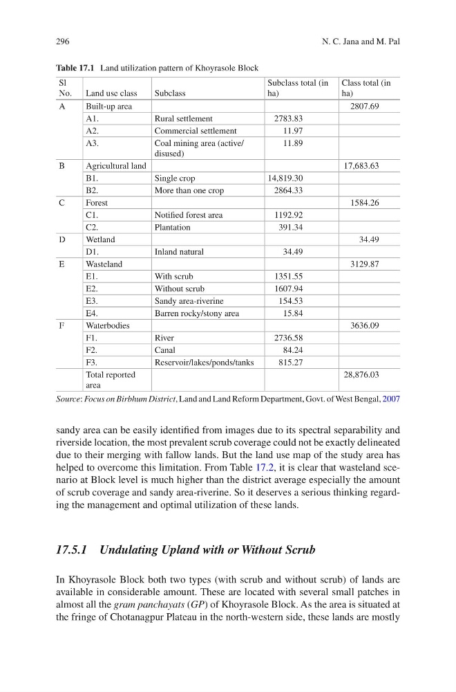
Table 17.1 Land utilization pattern of Khoyrasole Block
Sl
No.
Land use class
Subclass
Subclass total (in
ha)
Class total (in
ha)
A
Built-up area
2807.69
A1.
Rural settlement
2783.83
A2.
Commercial settlement
11.97
A3.
Coal mining area (active/
disused)
11.89
B
Agricultural land
17,683.63
B1.
Single crop
14,819.30
B2.
More than one crop
2864.33
C
Forest
1584.26
C1.
Notified forest area
1192.92
C2.
Plantation
391.34
D
Wetland
34.49
D1.
Inland natural
34.49
E
Wasteland
3129.87
E1.
With scrub
1351.55
E2.
Without scrub
1607.94
E3.
Sandy area-riverine
154.53
E4.
Barren rocky/stony area
15.84
F
Waterbodies
3636.09
F1.
River
2736.58
F2.
Canal
84.24
F3.
Reservoir/lakes/ponds/tanks
815.27
Total reported
area
28,876.03
Source: Focus on Birbhum District, Land and Land Reform Department, Govt. of West Bengal, 2007
N. C. Jana and M. Pal
sandy area can be easily identified from images due to its spectral separability and
riverside location, the most prevalent scrub coverage could not be exactly delineated
due to their merging with fallow lands. But the land use map of the study area has
helped to overcome this limitation. From Table 17.2, it is clear that wasteland scenario at Block level is much higher than the district average especially the amount
of scrub coverage and sandy area-riverine. So it deserves a serious thinking regarding the management and optimal utilization of these lands.
17.5.1 Undulating Upland with or Without Scrub
In Khoyrasole Block both two types (with scrub and without scrub) of lands are
available in considerable amount. These are located with several small patches in
almost all the gram panchayats (GP) of Khoyrasole Block. As the area is situated at
the fringe of Chotanagpur Plateau in the north-western side, these lands are mostly
Table 17.1 Land utilization pattern of Khoyrasole Block
Sl
No.
Land use class
Subclass
Subclass total (in
ha)
Class total (in
ha)
A
Built-up area
2807.69
A1.
Rural settlement
2783.83
A2.
Commercial settlement
11.97
A3.
Coal mining area (active/
disused)
11.89
B
Agricultural land
17,683.63
B1.
Single crop
14,819.30
B2.
More than one crop
2864.33
C
Forest
1584.26
C1.
Notified forest area
1192.92
C2.
Plantation
391.34
D
Wetland
34.49
D1.
Inland natural
34.49
E
Wasteland
3129.87
E1.
With scrub
1351.55
E2.
Without scrub
1607.94
E3.
Sandy area-riverine
154.53
E4.
Barren rocky/stony area
15.84
F
Waterbodies
3636.09
F1.
River
2736.58
F2.
Canal
84.24
F3.
Reservoir/lakes/ponds/tanks
815.27
Total reported
area
28,876.03
Source: Focus on Birbhum District, Land and Land Reform Department, Govt. of West Bengal, 2007
N. C. Jana and M. Pal