

152
et al. 2016). It can be seen that built-up areas reflectance to be higher at SWIR and
TIR wavelengths (B5, B6) and low in NIR (Band 4) band and high contrast or
reflectance value of vegetation found in near infrared band which is Band 4 on TM
and ETM+ and Band 5 on OLI, and therefore these band (SWIR and TIR) associated with a high contrast for detecting built-up and bare land areas has been used in
different researchers. Further, there exists an inverse reflectance relationship in
Band 4 and Band 5 between built-up or bare land areas and vegetation. Vegetation
has a higher reflectance in Band 4 than the reflectance of built-up or bare land, while
in Band 5 the reflectance of built-up is higher than vegetated areas (Herold et al.
2003). The TIR band has the ability to distinguish high and low levels of albedo in
built-up objects (Zhao and Chen 2005), which can be used for mapping built-up
areas based on a low albedo, which eliminates the effect of shadows and water while
high albedo demonstrates built-up and bare land (Weng 2008). The use of SWIR in
this study in place of NIR band in commonly used Normalised Difference Water
Index (NDWI) is due to high built-up area reflectance in SWIR compared to
NIR. Thus, the resulting index will have negative values for the built-up area and
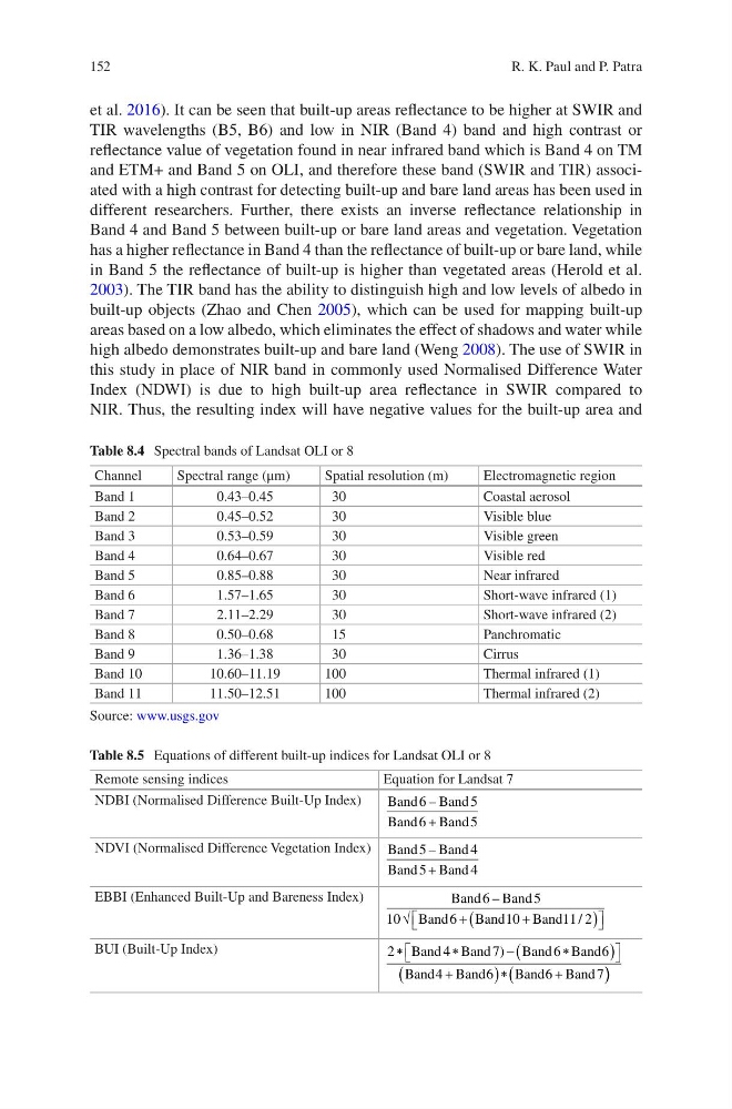
Table 8.4 Spectral bands of Landsat OLI or 8
Channel
Spectral range (μm)
Spatial resolution (m)
Electromagnetic region
Band 1
0.43–0.45
30
Coastal aerosol
Band 2
0.45–0.52
30
Visible blue
Band 3
0.53–0.59
30
Visible green
Band 4
0.64–0.67
30
Visible red
Band 5
0.85–0.88
30
Near infrared
Band 6
1.57–1.65
30
Short-wave infrared (1)
Band 7
2.11–2.29
30
Short-wave infrared (2)
Band 8
0.50–0.68
15
Panchromatic
Band 9
1.36–1.38
30
Cirrus
Band 10
10.60–11.19
100
Thermal infrared (1)
Band 11
11.50–12.51
100
Thermal infrared (2)
Source: www.usgs.gov
Table 8.5 Equations of different built-up indices for Landsat OLI or 8
Remote sensing indices
Equation for Landsat 7
NDBI (Normalised Difference Built-Up Index)
Band
Band
Band
Band
6
5
6
5
–
+
NDVI (Normalised Difference Vegetation Index) Band Band
Band
Band
5
4
5
4
–
+
EBBI (Enhanced Built-Up and Bareness Index)
Band
Band
Band
Band
Band
6
5
10
6
1 0
1 1 2
–
/
√
+
+
(
)
BUI (Built-Up Index)
2
4
7
6
6
4
6
6
7
∗
∗
−
∗
(
)
+
(
) ∗
+
(
Band Band
Band Band
Band Band
Band Band
)
) )
R. K. Paul and P. Patra
et al. 2016). It can be seen that built-up areas reflectance to be higher at SWIR and
TIR wavelengths (B5, B6) and low in NIR (Band 4) band and high contrast or
reflectance value of vegetation found in near infrared band which is Band 4 on TM
and ETM+ and Band 5 on OLI, and therefore these band (SWIR and TIR) associated with a high contrast for detecting built-up and bare land areas has been used in
different researchers. Further, there exists an inverse reflectance relationship in
Band 4 and Band 5 between built-up or bare land areas and vegetation. Vegetation
has a higher reflectance in Band 4 than the reflectance of built-up or bare land, while
in Band 5 the reflectance of built-up is higher than vegetated areas (Herold et al.
2003). The TIR band has the ability to distinguish high and low levels of albedo in
built-up objects (Zhao and Chen 2005), which can be used for mapping built-up
areas based on a low albedo, which eliminates the effect of shadows and water while
high albedo demonstrates built-up and bare land (Weng 2008). The use of SWIR in
this study in place of NIR band in commonly used Normalised Difference Water
Index (NDWI) is due to high built-up area reflectance in SWIR compared to
NIR. Thus, the resulting index will have negative values for the built-up area and
Table 8.4 Spectral bands of Landsat OLI or 8
Channel
Spectral range (μm)
Spatial resolution (m)
Electromagnetic region
Band 1
0.43–0.45
30
Coastal aerosol
Band 2
0.45–0.52
30
Visible blue
Band 3
0.53–0.59
30
Visible green
Band 4
0.64–0.67
30
Visible red
Band 5
0.85–0.88
30
Near infrared
Band 6
1.57–1.65
30
Short-wave infrared (1)
Band 7
2.11–2.29
30
Short-wave infrared (2)
Band 8
0.50–0.68
15
Panchromatic
Band 9
1.36–1.38
30
Cirrus
Band 10
10.60–11.19
100
Thermal infrared (1)
Band 11
11.50–12.51
100
Thermal infrared (2)
Source: www.usgs.gov
Table 8.5 Equations of different built-up indices for Landsat OLI or 8
Remote sensing indices
Equation for Landsat 7
NDBI (Normalised Difference Built-Up Index)
Band
Band
Band
Band
6
5
6
5
–
+
NDVI (Normalised Difference Vegetation Index) Band Band
Band
Band
5
4
5
4
–
+
EBBI (Enhanced Built-Up and Bareness Index)
Band
Band
Band
Band
Band
6
5
10
6
1 0
1 1 2
–
/
√
+
+
(
)
BUI (Built-Up Index)
2
4
7
6
6
4
6
6
7
∗
∗
−
∗
(
)
+
(
) ∗
+
(
Band Band
Band Band
Band Band
Band Band
)
) )
R. K. Paul and P. Patra