

151
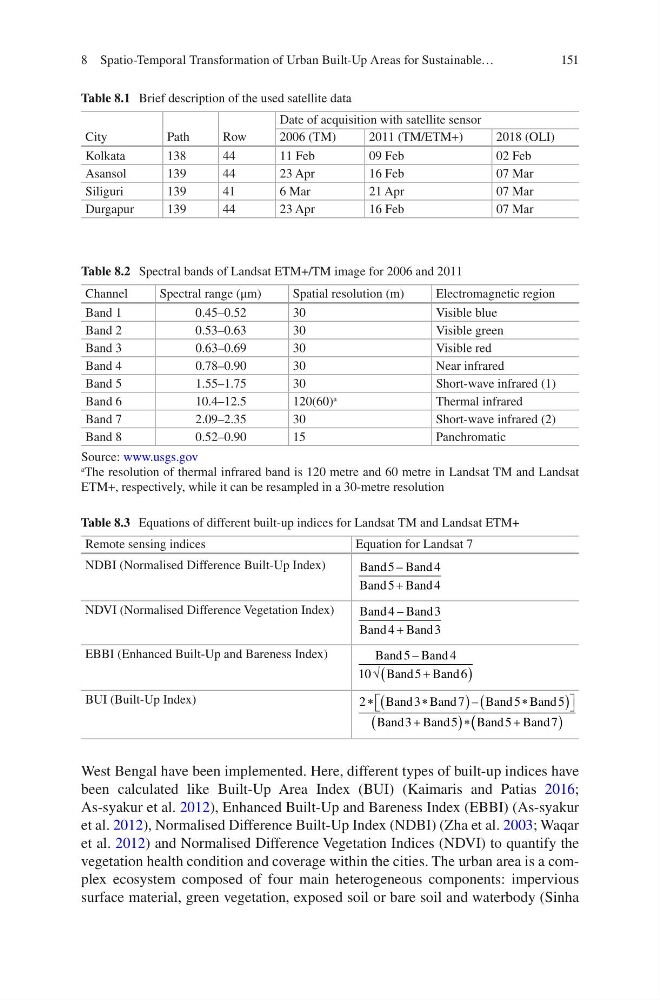
Table 8.1 Brief description of the used satellite data
City
Path
Row
Date of acquisition with satellite sensor
2006 (TM)
2011 (TM/ETM+)
2018 (OLI)
Kolkata
138
44
11 Feb
09 Feb
02 Feb
Asansol
139
44
23 Apr
16 Feb
07 Mar
Siliguri
139
41
6 Mar
21 Apr
07 Mar
Durgapur
139
44
23 Apr
16 Feb
07 Mar
Table 8.2 Spectral bands of Landsat ETM+/TM image for 2006 and 2011
Channel
Spectral range (μm)
Spatial resolution (m)
Electromagnetic region
Band 1
0.45–0.52
30
Visible blue
Band 2
0.53–0.63
30
Visible green
Band 3
0.63–0.69
30
Visible red
Band 4
0.78–0.90
30
Near infrared
Band 5
1.55–1.75
30
Short-wave infrared (1)
Band 6
10.4–12.5
120(60)
a
Thermal infrared
Band 7
2.09–2.35
30
Short-wave infrared (2)
Band 8
0.52–0.90
15
Panchromatic
Source: www.usgs.gov
a The resolution of thermal infrared band is 120 metre and 60 metre in Landsat TM and Landsat
ETM+, respectively, while it can be resampled in a 30-metre resolution
Table 8.3 Equations of different built-up indices for Landsat TM and Landsat ETM+
Remote sensing indices
Equation for Landsat 7
NDBI (Normalised Difference Built-Up Index)
Band Band
Band
Band
5
4
5
4
–
+
NDVI (Normalised Difference Vegetation Index)
Band
Band
Band
Band
4
3
4
3
–
+
EBBI (Enhanced Built-Up and Bareness Index)
Band Band
Band
Band
5
4
10
5
6
–
√
+
(
)
BUI (Built-Up Index)
2
3
7
5
5
3
5
5
7
∗
∗
(
)
∗
(
)
+
(
) ∗
+
Band Band
Band Band
Band Band
Band
Band
–
( (
)
West Bengal have been implemented. Here, different types of built-up indices have
been calculated like Built-Up Area Index (BUI) (Kaimaris and Patias 2016;
As-syakur et al. 2012), Enhanced Built-Up and Bareness Index (EBBI) (As-syakur
et al. 2012), Normalised Difference Built-Up Index (NDBI) (Zha et al. 2003; Waqar
et al. 2012) and Normalised Difference Vegetation Indices (NDVI) to quantify the
vegetation health condition and coverage within the cities. The urban area is a complex ecosystem composed of four main heterogeneous components: impervious
surface material, green vegetation, exposed soil or bare soil and waterbody (Sinha
8 Spatio-Temporal Transformation of Urban Built-Up Areas for Sustainable…
Table 8.1 Brief description of the used satellite data
City
Path
Row
Date of acquisition with satellite sensor
2006 (TM)
2011 (TM/ETM+)
2018 (OLI)
Kolkata
138
44
11 Feb
09 Feb
02 Feb
Asansol
139
44
23 Apr
16 Feb
07 Mar
Siliguri
139
41
6 Mar
21 Apr
07 Mar
Durgapur
139
44
23 Apr
16 Feb
07 Mar
Table 8.2 Spectral bands of Landsat ETM+/TM image for 2006 and 2011
Channel
Spectral range (μm)
Spatial resolution (m)
Electromagnetic region
Band 1
0.45–0.52
30
Visible blue
Band 2
0.53–0.63
30
Visible green
Band 3
0.63–0.69
30
Visible red
Band 4
0.78–0.90
30
Near infrared
Band 5
1.55–1.75
30
Short-wave infrared (1)
Band 6
10.4–12.5
120(60)
a
Thermal infrared
Band 7
2.09–2.35
30
Short-wave infrared (2)
Band 8
0.52–0.90
15
Panchromatic
Source: www.usgs.gov
a The resolution of thermal infrared band is 120 metre and 60 metre in Landsat TM and Landsat
ETM+, respectively, while it can be resampled in a 30-metre resolution
Table 8.3 Equations of different built-up indices for Landsat TM and Landsat ETM+
Remote sensing indices
Equation for Landsat 7
NDBI (Normalised Difference Built-Up Index)
Band Band
Band
Band
5
4
5
4
–
+
NDVI (Normalised Difference Vegetation Index)
Band
Band
Band
Band
4
3
4
3
–
+
EBBI (Enhanced Built-Up and Bareness Index)
Band Band
Band
Band
5
4
10
5
6
–
√
+
(
)
BUI (Built-Up Index)
2
3
7
5
5
3
5
5
7
∗
∗
(
)
∗
(
)
+
(
) ∗
+
Band Band
Band Band
Band Band
Band
Band
–
( (
)
West Bengal have been implemented. Here, different types of built-up indices have
been calculated like Built-Up Area Index (BUI) (Kaimaris and Patias 2016;
As-syakur et al. 2012), Enhanced Built-Up and Bareness Index (EBBI) (As-syakur
et al. 2012), Normalised Difference Built-Up Index (NDBI) (Zha et al. 2003; Waqar
et al. 2012) and Normalised Difference Vegetation Indices (NDVI) to quantify the
vegetation health condition and coverage within the cities. The urban area is a complex ecosystem composed of four main heterogeneous components: impervious
surface material, green vegetation, exposed soil or bare soil and waterbody (Sinha
8 Spatio-Temporal Transformation of Urban Built-Up Areas for Sustainable…