

of Lake Erie. Areas to the south of the hinge line on Lake
Erie have experienced permanent depression of up to 65 ft.
(20 m). Glacio-isostatic adjustment continues today, necessitating adjustment of vertical datums of the Great Lakes
every 25–35 years as part of the requirements permitting
hydropower water diversions, navigation, and other uses.
During and following the Laurentide ice fluctuations,
glacial and postglacial lakes formed in the Great Lakes
basin. Figure 2.15 shows shorelines of prominent postglacial
lakes in the Great Lakes watershed and their spillways and
outlets. Erosional evidence of former lake levels include
headlands, spillways, inlet lakes, sea caves, and sea stacks.
Headlands are promontories with a sheer drop along a
coastline caused by intense wave action. Spillways represent
former river valleys where water passed between lakes. Inlet
(bay-mouth) lakes are formed by stream incision during low
lake stands followed by drowning of these old river valleys
during high stands. Sea caves (cavettos) are formed by wave
action in a lake or the ocean; and sea stacks are columns of
resistant bedrock left from intense wave action along a
shoreline.
Evidence of catastrophic erosion from outbursts of glacial
Lake Agassiz include boulder fields, closed basins, dry
cataracts, plunge pools, and giant potholes. Boulder fields
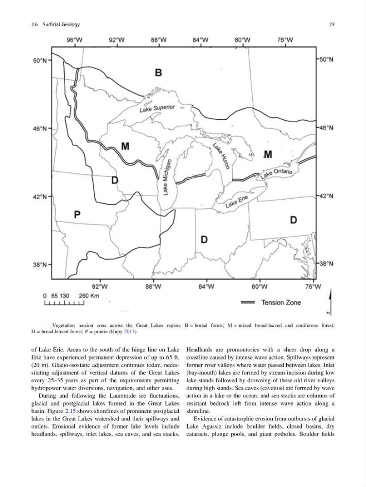
Fig. 2.6 Vegetation tension zone across the Great Lakes region: B = boreal forest; M = mixed broad-leaved and coniferous forest;
D = broad-leaved forest; P = prairie (Hupy 2013)
2.6 Surficial Geology
23
Erie have experienced permanent depression of up to 65 ft.
(20 m). Glacio-isostatic adjustment continues today, necessitating adjustment of vertical datums of the Great Lakes
every 25–35 years as part of the requirements permitting
hydropower water diversions, navigation, and other uses.
During and following the Laurentide ice fluctuations,
glacial and postglacial lakes formed in the Great Lakes
basin. Figure 2.15 shows shorelines of prominent postglacial
lakes in the Great Lakes watershed and their spillways and
outlets. Erosional evidence of former lake levels include
headlands, spillways, inlet lakes, sea caves, and sea stacks.
Headlands are promontories with a sheer drop along a
coastline caused by intense wave action. Spillways represent
former river valleys where water passed between lakes. Inlet
(bay-mouth) lakes are formed by stream incision during low
lake stands followed by drowning of these old river valleys
during high stands. Sea caves (cavettos) are formed by wave
action in a lake or the ocean; and sea stacks are columns of
resistant bedrock left from intense wave action along a
shoreline.
Evidence of catastrophic erosion from outbursts of glacial
Lake Agassiz include boulder fields, closed basins, dry
cataracts, plunge pools, and giant potholes. Boulder fields
Fig. 2.6 Vegetation tension zone across the Great Lakes region: B = boreal forest; M = mixed broad-leaved and coniferous forest;
D = broad-leaved forest; P = prairie (Hupy 2013)
2.6 Surficial Geology
23