

2.5
Bedrock Geology
Nearly all of the Lake Superior basin and the north shore of
Georgian Bay are part of the Canadian Shield and are
composed of granites and gneisses (Fig. 2.10). Sedimentary
rocks comprise the Michigan Basin, which is a geologic
basin centered on the Lower Peninsula but including all of
the Lakes Michigan and most of the Lake Huron and Lake
Erie basins. The Michigan Basin is a depression containing
limestones, dolomitic limestones, sandstones and shales.
The Niagara Escarpment, a long escarpment or cuesta
composed of dolomitic limestone, extends from the Genesee
River along the south shore of Lake Ontario to the northwest
along the Bruce Peninsula and Manitoulin Island in Lake
Huron, and around the northern and western shores of Lake
Michigan (Fig. 2.11). A 435-mile (725-km) stretch of the
escarpment from Niagara Falls to the tip of the Bruce
Peninsula composes one of six UNESCO World Biosphere
Reserves along the Great Lakes shores.
2.6
Surficial Geology
(Note a word about geologic dating: rocks and other materials are dated by a variety of techniques. Most of the dates
included here were determined from the radiocarbon
method. Therefore, I follow the convention of using “years
Before Present,” or kyr (thousands of years) and Ma (millions of years) BP. Some publications provide calendar
(uncorrected) dates, i.e., cal yr BP. More recent publications
have used Thermoluminescence, TL; Optically Stimulated
Luminescence, OSL; Accelerator Mass Spectrometry, AMS;
and other dating techniques.)
The entire Great lakes basin was glaciated during the Port
Huron advance of the late Wisconsinan (Fig. 2.12). The
pre-existing topography of the basin played an important
role in directing the flow of glacial ice. The Des Moines lobe
in the west passed in a NW–SE direction; the lobes over
Lakes Michigan and Huron moved nearly N–S; and Lake
Ontario received ice directed by the Appalachian Mountains
from E–W.
The Laurentide ice left predominantly eroded landforms
in the northern Lake Superior and Lake Huron basins and
deposited till, outwash, and glaciolacustrine materials in the
southern Great Lakes basin (Fig. 2.13). Evidence of glacial
erosion include striations, scoured bedrock, U-shaped valleys, roches moutonnées, over-deepenings, and other features. Roche moutonnées refer to rock formations with an
asymmetric erosional form as a result of abrasion on the
“stoss” (upstream) side of the rock and plucking on the “lee”
(downstream) side. Glacial depositional features include
moraines, kames, drumlins, eskers, and outwash fans.
A moraine is a landform comprised of unconsolidated glacial
debris. Kames are steep-sided mounds of sand and gravel
deposited by a melting ice sheet. Drumlins are elongated
hills that reflect erosion or deposition by a glacier that parallel the direction of ice movement at the time of formation.
Eskers are long, winding ridges of stratified sand and gravel
formed within ice-walled tunnels by steams which flowed
within and under glaciers. Outwash fans are fan-shaped
bodies of sediments deposited by braised streams from a
melting glacier.
There were at least six glaciations in the Great Lakes
basin over the past 20 kyr, including from oldest to
youngest, the Valparaiso, Tinley-Defiance, Lake Border,
Port Huron, Greatlakean, and Marquette advances. The
deposits are named are type localities based on association
with a particular lobe of ice advancing into the basin. By 9.5
ky BP, Laurentide ice had left the Great Lakes basin.
During the Laurentide glaciations, the ice mass depressed
the land; the land rebounded isostatically following recession of the ice. Figure 2.14 shows that the land was up to
980 ft. (300 m) lower in the northern Lake Superior basin
13,000 years ago than at present due to the mass of the
Laurentide ice. The diagram shows that the “hinge-line,” or
0 feet of uplift passes through the middle of Lake Michigan,
the southern tip of Lake Huron, and the northwestern portion
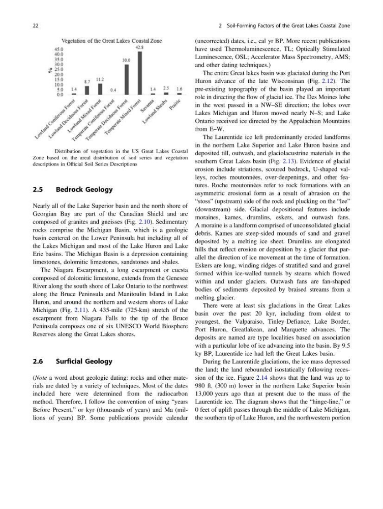
Fig. 2.5 Distribution of vegetation in the US Great Lakes Coastal
Zone based on the areal distribution of soil series and vegetation
descriptions in Official Soil Series Descriptions
22
2 Soil-Forming Factors of the Great Lakes Coastal Zone
Bedrock Geology
Nearly all of the Lake Superior basin and the north shore of
Georgian Bay are part of the Canadian Shield and are
composed of granites and gneisses (Fig. 2.10). Sedimentary
rocks comprise the Michigan Basin, which is a geologic
basin centered on the Lower Peninsula but including all of
the Lakes Michigan and most of the Lake Huron and Lake
Erie basins. The Michigan Basin is a depression containing
limestones, dolomitic limestones, sandstones and shales.
The Niagara Escarpment, a long escarpment or cuesta
composed of dolomitic limestone, extends from the Genesee
River along the south shore of Lake Ontario to the northwest
along the Bruce Peninsula and Manitoulin Island in Lake
Huron, and around the northern and western shores of Lake
Michigan (Fig. 2.11). A 435-mile (725-km) stretch of the
escarpment from Niagara Falls to the tip of the Bruce
Peninsula composes one of six UNESCO World Biosphere
Reserves along the Great Lakes shores.
2.6
Surficial Geology
(Note a word about geologic dating: rocks and other materials are dated by a variety of techniques. Most of the dates
included here were determined from the radiocarbon
method. Therefore, I follow the convention of using “years
Before Present,” or kyr (thousands of years) and Ma (millions of years) BP. Some publications provide calendar
(uncorrected) dates, i.e., cal yr BP. More recent publications
have used Thermoluminescence, TL; Optically Stimulated
Luminescence, OSL; Accelerator Mass Spectrometry, AMS;
and other dating techniques.)
The entire Great lakes basin was glaciated during the Port
Huron advance of the late Wisconsinan (Fig. 2.12). The
pre-existing topography of the basin played an important
role in directing the flow of glacial ice. The Des Moines lobe
in the west passed in a NW–SE direction; the lobes over
Lakes Michigan and Huron moved nearly N–S; and Lake
Ontario received ice directed by the Appalachian Mountains
from E–W.
The Laurentide ice left predominantly eroded landforms
in the northern Lake Superior and Lake Huron basins and
deposited till, outwash, and glaciolacustrine materials in the
southern Great Lakes basin (Fig. 2.13). Evidence of glacial
erosion include striations, scoured bedrock, U-shaped valleys, roches moutonnées, over-deepenings, and other features. Roche moutonnées refer to rock formations with an
asymmetric erosional form as a result of abrasion on the
“stoss” (upstream) side of the rock and plucking on the “lee”
(downstream) side. Glacial depositional features include
moraines, kames, drumlins, eskers, and outwash fans.
A moraine is a landform comprised of unconsolidated glacial
debris. Kames are steep-sided mounds of sand and gravel
deposited by a melting ice sheet. Drumlins are elongated
hills that reflect erosion or deposition by a glacier that parallel the direction of ice movement at the time of formation.
Eskers are long, winding ridges of stratified sand and gravel
formed within ice-walled tunnels by steams which flowed
within and under glaciers. Outwash fans are fan-shaped
bodies of sediments deposited by braised streams from a
melting glacier.
There were at least six glaciations in the Great Lakes
basin over the past 20 kyr, including from oldest to
youngest, the Valparaiso, Tinley-Defiance, Lake Border,
Port Huron, Greatlakean, and Marquette advances. The
deposits are named are type localities based on association
with a particular lobe of ice advancing into the basin. By 9.5
ky BP, Laurentide ice had left the Great Lakes basin.
During the Laurentide glaciations, the ice mass depressed
the land; the land rebounded isostatically following recession of the ice. Figure 2.14 shows that the land was up to
980 ft. (300 m) lower in the northern Lake Superior basin
13,000 years ago than at present due to the mass of the
Laurentide ice. The diagram shows that the “hinge-line,” or
0 feet of uplift passes through the middle of Lake Michigan,
the southern tip of Lake Huron, and the northwestern portion
Fig. 2.5 Distribution of vegetation in the US Great Lakes Coastal
Zone based on the areal distribution of soil series and vegetation
descriptions in Official Soil Series Descriptions
22
2 Soil-Forming Factors of the Great Lakes Coastal Zone