

97
Below is a short summary of McHarg’s analysis of the dunes and its probability of human use and
development:
The processes that determine dune creation are under the control of the waves and the wind. Waves usually
approach beaches from an angle, and the sand carried by the receding wave is transported down drift of its origin.
This is described as littoral drift and is a major factor in determines the formation of the beach and dunes. The
winds close to the shore contribute salt spray, and thus influence the type of vegetation that grows on the dunes.
As the dunes begin to form, vegetation colonise from seeds blown onto the dunes, and is further enhanced due
to the arresting grains of sand and the prism of freshwater that is captured within a dune formation. Carried from
inland, beach heather consolidate on the original dune, and in the trough vegetation grows to assist with protection of the secondary dune, which then results in woody plant material that grows on the lower third back dune.
In the final stage the beach remains free of vegetation, but the primary dune is a thick dune with dune grass while
in the trough nestle low beach heather, the face of the inland secondary dune, on the back dune there is stabilised
woodlands, grass and beach heather on the perimeter and the landscape graduates into a swampy salt marsh and
reed grass as part of the estuary (McHarg, 1992 [1969], pp. 7-18).
We can now draw conclusions from this simple analysis by McHarg, considering that since this is
a continuous, changing and evolving environment, the tolerance or intolerance of human interference
could guide settlement possibilities:
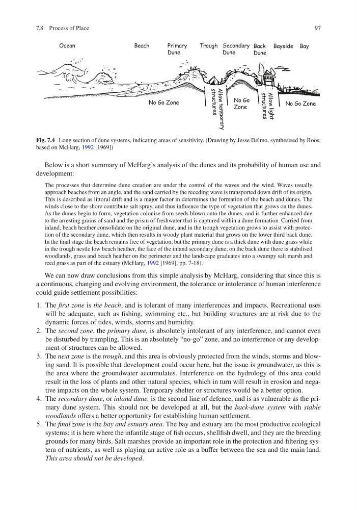
1. The first zone is the beach, and is tolerant of many interferences and impacts. Recreational uses
will be adequate, such as fishing, swimming etc., but building structures are at risk due to the
dynamic forces of tides, winds, storms and humidity.
2. The second zone, the primary dune, is absolutely intolerant of any interference, and cannot even
be disturbed by trampling. This is an absolutely “no-go” zone, and no interference or any development of structures can be allowed.
3. The next zone is the trough, and this area is obviously protected from the winds, storms and blowing sand. It is possible that development could occur here, but the issue is groundwater, as this is
the area where the groundwater accumulates. Interference on the hydrology of this area could
result in the loss of plants and other natural species, which in turn will result in erosion and negative impacts on the whole system. Temporary shelter or structures would be a better option.
4. The secondary dune, or inland dune, is the second line of defence, and is as vulnerable as the primary dune system. This should not be developed at all, but the back-dune system with stable
woodlands offers a better opportunity for establishing human settlement.
5. The final zone is the bay and estuary area. The bay and estuary are the most productive ecological
systems; it is here where the infantile stage of fish occurs, shellfish dwell, and they are the breeding
grounds for many birds. Salt marshes provide an important role in the protection and filtering system of nutrients, as well as playing an active role as a buffer between the sea and the main land.
This area should not be developed.
Fig. 7.4 Long section of dune systems, indicating areas of sensitivity. (Drawing by Jesse Delmo, synthesised by Roös,
based on McHarg, 1992 [1969])
7.8 Process of Place
Below is a short summary of McHarg’s analysis of the dunes and its probability of human use and
development:
The processes that determine dune creation are under the control of the waves and the wind. Waves usually
approach beaches from an angle, and the sand carried by the receding wave is transported down drift of its origin.
This is described as littoral drift and is a major factor in determines the formation of the beach and dunes. The
winds close to the shore contribute salt spray, and thus influence the type of vegetation that grows on the dunes.
As the dunes begin to form, vegetation colonise from seeds blown onto the dunes, and is further enhanced due
to the arresting grains of sand and the prism of freshwater that is captured within a dune formation. Carried from
inland, beach heather consolidate on the original dune, and in the trough vegetation grows to assist with protection of the secondary dune, which then results in woody plant material that grows on the lower third back dune.
In the final stage the beach remains free of vegetation, but the primary dune is a thick dune with dune grass while
in the trough nestle low beach heather, the face of the inland secondary dune, on the back dune there is stabilised
woodlands, grass and beach heather on the perimeter and the landscape graduates into a swampy salt marsh and
reed grass as part of the estuary (McHarg, 1992 [1969], pp. 7-18).
We can now draw conclusions from this simple analysis by McHarg, considering that since this is
a continuous, changing and evolving environment, the tolerance or intolerance of human interference
could guide settlement possibilities:
1. The first zone is the beach, and is tolerant of many interferences and impacts. Recreational uses
will be adequate, such as fishing, swimming etc., but building structures are at risk due to the
dynamic forces of tides, winds, storms and humidity.
2. The second zone, the primary dune, is absolutely intolerant of any interference, and cannot even
be disturbed by trampling. This is an absolutely “no-go” zone, and no interference or any development of structures can be allowed.
3. The next zone is the trough, and this area is obviously protected from the winds, storms and blowing sand. It is possible that development could occur here, but the issue is groundwater, as this is
the area where the groundwater accumulates. Interference on the hydrology of this area could
result in the loss of plants and other natural species, which in turn will result in erosion and negative impacts on the whole system. Temporary shelter or structures would be a better option.
4. The secondary dune, or inland dune, is the second line of defence, and is as vulnerable as the primary dune system. This should not be developed at all, but the back-dune system with stable
woodlands offers a better opportunity for establishing human settlement.
5. The final zone is the bay and estuary area. The bay and estuary are the most productive ecological
systems; it is here where the infantile stage of fish occurs, shellfish dwell, and they are the breeding
grounds for many birds. Salt marshes provide an important role in the protection and filtering system of nutrients, as well as playing an active role as a buffer between the sea and the main land.
This area should not be developed.
Fig. 7.4 Long section of dune systems, indicating areas of sensitivity. (Drawing by Jesse Delmo, synthesised by Roös,
based on McHarg, 1992 [1969])
7.8 Process of Place