

27
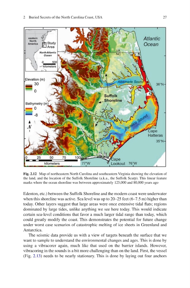
Edenton, etc.) between the Suffolk Shoreline and the modern coast were underwater
when this shoreline was active. Sea level was up to 20–25 feet (6–7.5 m) higher than
today. Other layers suggest that large areas were once extensive tidal flats; regions
dominated by large tides, unlike anything we see here today. This would indicate
certain sea-level conditions that favor a much larger tidal range than today, which
could greatly modify the coast. This demonstrates the potential for future change
under worst case scenarios of catastrophic melting of ice sheets in Greenland and
Antarctica.
The seismic data provide us with a view of targets beneath the surface that we
want to sample to understand the environmental changes and ages. This is done by
using a vibracorer again, much like that used on the barrier islands. However,
vibracoring in the sounds is a bit more challenging than on the land. First, the vessel
(Fig. 2.13) needs to be nearly stationary. This is done by laying out four anchors
Fig. 2.12 Map of northeastern North Carolina and southeastern Virginia showing the elevation of
the land, and the location of the Suffolk Shoreline (a.k.a., the Suffolk Scarp). This linear feature
marks where the ocean shoreline was between approximately 125,000 and 80,000 years ago
2 Buried Secrets of the North Carolina Coast, USA
Edenton, etc.) between the Suffolk Shoreline and the modern coast were underwater
when this shoreline was active. Sea level was up to 20–25 feet (6–7.5 m) higher than
today. Other layers suggest that large areas were once extensive tidal flats; regions
dominated by large tides, unlike anything we see here today. This would indicate
certain sea-level conditions that favor a much larger tidal range than today, which
could greatly modify the coast. This demonstrates the potential for future change
under worst case scenarios of catastrophic melting of ice sheets in Greenland and
Antarctica.
The seismic data provide us with a view of targets beneath the surface that we
want to sample to understand the environmental changes and ages. This is done by
using a vibracorer again, much like that used on the barrier islands. However,
vibracoring in the sounds is a bit more challenging than on the land. First, the vessel
(Fig. 2.13) needs to be nearly stationary. This is done by laying out four anchors
Fig. 2.12 Map of northeastern North Carolina and southeastern Virginia showing the elevation of
the land, and the location of the Suffolk Shoreline (a.k.a., the Suffolk Scarp). This linear feature
marks where the ocean shoreline was between approximately 125,000 and 80,000 years ago
2 Buried Secrets of the North Carolina Coast, USA