

26
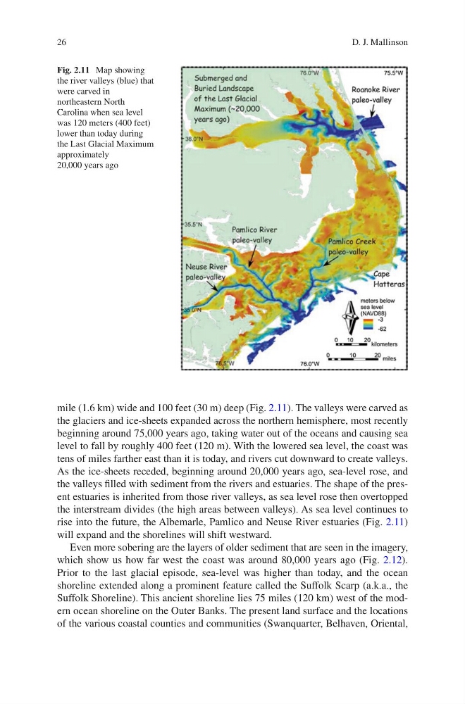
mile (1.6 km) wide and 100 feet (30 m) deep (Fig. 2.11). The valleys were carved as
the glaciers and ice-sheets expanded across the northern hemisphere, most recently
beginning around 75,000 years ago, taking water out of the oceans and causing sea
level to fall by roughly 400 feet (120 m). With the lowered sea level, the coast was
tens of miles farther east than it is today, and rivers cut downward to create valleys.
As the ice-sheets receded, beginning around 20,000 years ago, sea-level rose, and
the valleys filled with sediment from the rivers and estuaries. The shape of the present estuaries is inherited from those river valleys, as sea level rose then overtopped
the interstream divides (the high areas between valleys). As sea level continues to
rise into the future, the Albemarle, Pamlico and Neuse River estuaries (Fig. 2.11)
will expand and the shorelines will shift westward.
Even more sobering are the layers of older sediment that are seen in the imagery,
which show us how far west the coast was around 80,000 years ago (Fig. 2.12).
Prior to the last glacial episode, sea-level was higher than today, and the ocean
shoreline extended along a prominent feature called the Suffolk Scarp (a.k.a., the
Suffolk Shoreline). This ancient shoreline lies 75 miles (120 km) west of the modern ocean shoreline on the Outer Banks. The present land surface and the locations
of the various coastal counties and communities (Swanquarter, Belhaven, Oriental,
Fig. 2.11 Map showing
the river valleys (blue) that
were carved in
northeastern North
Carolina when sea level
was 120 meters (400 feet)
lower than today during
the Last Glacial Maximum
approximately
20,000 years ago
D. J. Mallinson
mile (1.6 km) wide and 100 feet (30 m) deep (Fig. 2.11). The valleys were carved as
the glaciers and ice-sheets expanded across the northern hemisphere, most recently
beginning around 75,000 years ago, taking water out of the oceans and causing sea
level to fall by roughly 400 feet (120 m). With the lowered sea level, the coast was
tens of miles farther east than it is today, and rivers cut downward to create valleys.
As the ice-sheets receded, beginning around 20,000 years ago, sea-level rose, and
the valleys filled with sediment from the rivers and estuaries. The shape of the present estuaries is inherited from those river valleys, as sea level rose then overtopped
the interstream divides (the high areas between valleys). As sea level continues to
rise into the future, the Albemarle, Pamlico and Neuse River estuaries (Fig. 2.11)
will expand and the shorelines will shift westward.
Even more sobering are the layers of older sediment that are seen in the imagery,
which show us how far west the coast was around 80,000 years ago (Fig. 2.12).
Prior to the last glacial episode, sea-level was higher than today, and the ocean
shoreline extended along a prominent feature called the Suffolk Scarp (a.k.a., the
Suffolk Shoreline). This ancient shoreline lies 75 miles (120 km) west of the modern ocean shoreline on the Outer Banks. The present land surface and the locations
of the various coastal counties and communities (Swanquarter, Belhaven, Oriental,
Fig. 2.11 Map showing
the river valleys (blue) that
were carved in
northeastern North
Carolina when sea level
was 120 meters (400 feet)
lower than today during
the Last Glacial Maximum
approximately
20,000 years ago
D. J. Mallinson