

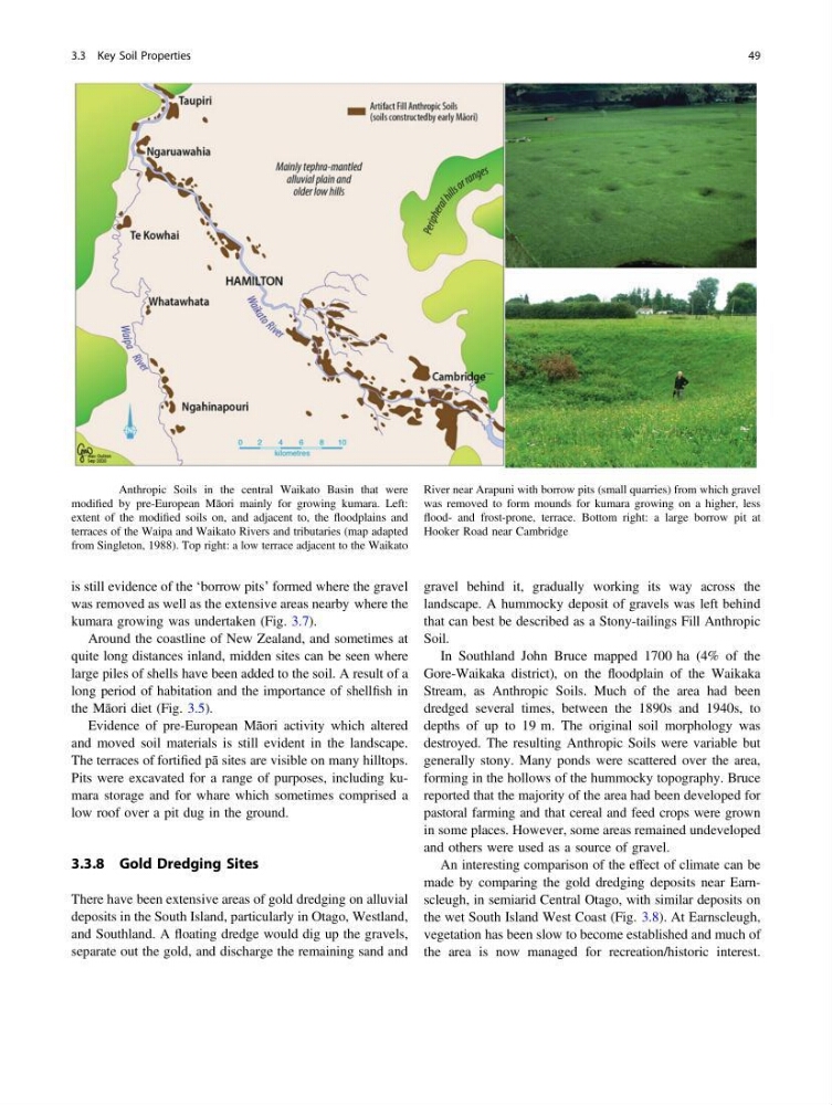
is still evidence of the ‘borrow pits’ formed where the gravel
was removed as well as the extensive areas nearby where the
kumara growing was undertaken (Fig. 3.7).
Around the coastline of New Zealand, and sometimes at
quite long distances inland, midden sites can be seen where
large piles of shells have been added to the soil. A result of a
long period of habitation and the importance of shellfish in
the Māori diet (Fig. 3.5).
Evidence of pre-European Māori activity which altered
and moved soil materials is still evident in the landscape.
The terraces of fortified pā sites are visible on many hilltops.
Pits were excavated for a range of purposes, including kumara storage and for whare which sometimes comprised a
low roof over a pit dug in the ground.
3.3.8 Gold Dredging Sites
There have been extensive areas of gold dredging on alluvial
deposits in the South Island, particularly in Otago, Westland,
and Southland. A floating dredge would dig up the gravels,
separate out the gold, and discharge the remaining sand and
gravel behind it, gradually working its way across the
landscape. A hummocky deposit of gravels was left behind
that can best be described as a Stony-tailings Fill Anthropic
Soil.
In Southland John Bruce mapped 1700 ha (4% of the
Gore-Waikaka district), on the floodplain of the Waikaka
Stream, as Anthropic Soils. Much of the area had been
dredged several times, between the 1890s and 1940s, to
depths of up to 19 m. The original soil morphology was
destroyed. The resulting Anthropic Soils were variable but
generally stony. Many ponds were scattered over the area,
forming in the hollows of the hummocky topography. Bruce
reported that the majority of the area had been developed for
pastoral farming and that cereal and feed crops were grown
in some places. However, some areas remained undeveloped
and others were used as a source of gravel.
An interesting comparison of the effect of climate can be
made by comparing the gold dredging deposits near Earnscleugh, in semiarid Central Otago, with similar deposits on
the wet South Island West Coast (Fig. 3.8). At Earnscleugh,
vegetation has been slow to become established and much of
the area is now managed for recreation/historic interest.
Fig. 3.7 Anthropic Soils in the central Waikato Basin that were
modified by pre-European Māori mainly for growing kumara. Left:
extent of the modified soils on, and adjacent to, the floodplains and
terraces of the Waipa and Waikato Rivers and tributaries (map adapted
from Singleton, 1988). Top right: a low terrace adjacent to the Waikato
River near Arapuni with borrow pits (small quarries) from which gravel
was removed to form mounds for kumara growing on a higher, less
flood- and frost-prone, terrace. Bottom right: a large borrow pit at
Hooker Road near Cambridge
3.3 Key Soil Properties
49
was removed as well as the extensive areas nearby where the
kumara growing was undertaken (Fig. 3.7).
Around the coastline of New Zealand, and sometimes at
quite long distances inland, midden sites can be seen where
large piles of shells have been added to the soil. A result of a
long period of habitation and the importance of shellfish in
the Māori diet (Fig. 3.5).
Evidence of pre-European Māori activity which altered
and moved soil materials is still evident in the landscape.
The terraces of fortified pā sites are visible on many hilltops.
Pits were excavated for a range of purposes, including kumara storage and for whare which sometimes comprised a
low roof over a pit dug in the ground.
3.3.8 Gold Dredging Sites
There have been extensive areas of gold dredging on alluvial
deposits in the South Island, particularly in Otago, Westland,
and Southland. A floating dredge would dig up the gravels,
separate out the gold, and discharge the remaining sand and
gravel behind it, gradually working its way across the
landscape. A hummocky deposit of gravels was left behind
that can best be described as a Stony-tailings Fill Anthropic
Soil.
In Southland John Bruce mapped 1700 ha (4% of the
Gore-Waikaka district), on the floodplain of the Waikaka
Stream, as Anthropic Soils. Much of the area had been
dredged several times, between the 1890s and 1940s, to
depths of up to 19 m. The original soil morphology was
destroyed. The resulting Anthropic Soils were variable but
generally stony. Many ponds were scattered over the area,
forming in the hollows of the hummocky topography. Bruce
reported that the majority of the area had been developed for
pastoral farming and that cereal and feed crops were grown
in some places. However, some areas remained undeveloped
and others were used as a source of gravel.
An interesting comparison of the effect of climate can be
made by comparing the gold dredging deposits near Earnscleugh, in semiarid Central Otago, with similar deposits on
the wet South Island West Coast (Fig. 3.8). At Earnscleugh,
vegetation has been slow to become established and much of
the area is now managed for recreation/historic interest.
Fig. 3.7 Anthropic Soils in the central Waikato Basin that were
modified by pre-European Māori mainly for growing kumara. Left:
extent of the modified soils on, and adjacent to, the floodplains and
terraces of the Waipa and Waikato Rivers and tributaries (map adapted
from Singleton, 1988). Top right: a low terrace adjacent to the Waikato
River near Arapuni with borrow pits (small quarries) from which gravel
was removed to form mounds for kumara growing on a higher, less
flood- and frost-prone, terrace. Bottom right: a large borrow pit at
Hooker Road near Cambridge
3.3 Key Soil Properties
49