

(ii) drift surface morphology (e.g. thin, loose gravelly sands,
pebbles, and boulders on ice versus strongly patterned
ground on relatively deep profiles), (iii) surface boulder
weathering, (iv) soil morphology (depth, texture, colour,
pseudomorphs, mineralogy), and (v) other profile features
such as salt content and pH. Some of the soils contain buried
soils, showing up as oxidised horizons at depth.
17.3.5 Soils and Meteorites
Iron meteorites (16 specimens in total, the largest weighing
138 kg) were discovered on Derrick Peak in the Britannia
Range in 1978 (Fig. 17.15). Peter Kamp and David Lowe
used the soil/drift ages to help constrain the terrestrial age of
the meteorites (i.e. when the meteorites had landed on
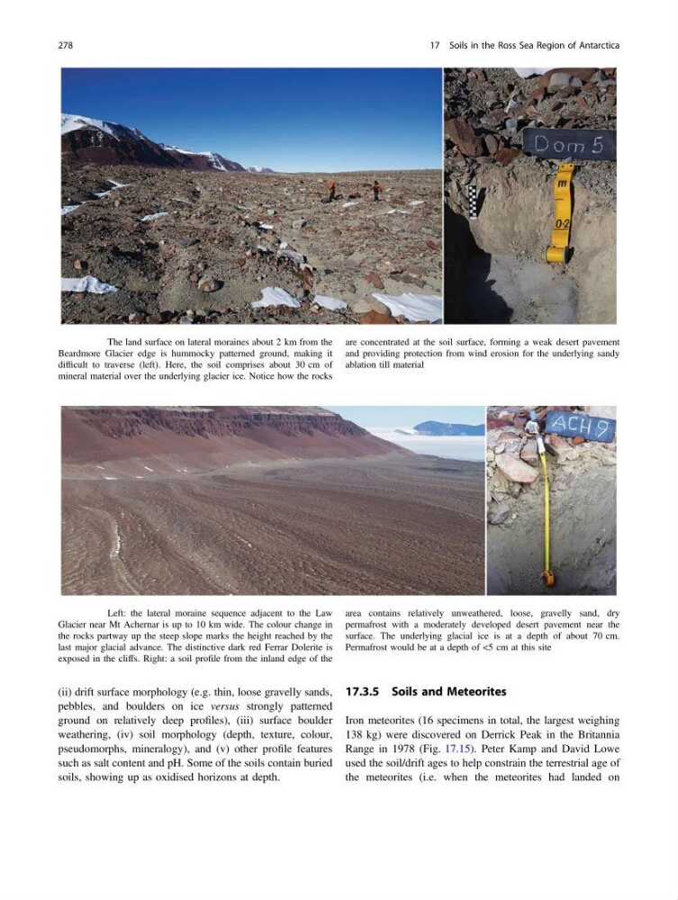
Fig. 17.12 The land surface on lateral moraines about 2 km from the
Beardmore Glacier edge is hummocky patterned ground, making it
difficult to traverse (left). Here, the soil comprises about 30 cm of
mineral material over the underlying glacier ice. Notice how the rocks
are concentrated at the soil surface, forming a weak desert pavement
and providing protection from wind erosion for the underlying sandy
ablation till material
Fig. 17.13 Left: the lateral moraine sequence adjacent to the Law
Glacier near Mt Achernar is up to 10 km wide. The colour change in
the rocks partway up the steep slope marks the height reached by the
last major glacial advance. The distinctive dark red Ferrar Dolerite is
exposed in the cliffs. Right: a soil profile from the inland edge of the
area contains relatively unweathered, loose, gravelly sand, dry
permafrost with a moderately developed desert pavement near the
surface. The underlying glacial ice is at a depth of about 70 cm.
Permafrost would be at a depth of <5 cm at this site
278
17 Soils in the Ross Sea Region of Antarctica
pebbles, and boulders on ice versus strongly patterned
ground on relatively deep profiles), (iii) surface boulder
weathering, (iv) soil morphology (depth, texture, colour,
pseudomorphs, mineralogy), and (v) other profile features
such as salt content and pH. Some of the soils contain buried
soils, showing up as oxidised horizons at depth.
17.3.5 Soils and Meteorites
Iron meteorites (16 specimens in total, the largest weighing
138 kg) were discovered on Derrick Peak in the Britannia
Range in 1978 (Fig. 17.15). Peter Kamp and David Lowe
used the soil/drift ages to help constrain the terrestrial age of
the meteorites (i.e. when the meteorites had landed on
Fig. 17.12 The land surface on lateral moraines about 2 km from the
Beardmore Glacier edge is hummocky patterned ground, making it
difficult to traverse (left). Here, the soil comprises about 30 cm of
mineral material over the underlying glacier ice. Notice how the rocks
are concentrated at the soil surface, forming a weak desert pavement
and providing protection from wind erosion for the underlying sandy
ablation till material
Fig. 17.13 Left: the lateral moraine sequence adjacent to the Law
Glacier near Mt Achernar is up to 10 km wide. The colour change in
the rocks partway up the steep slope marks the height reached by the
last major glacial advance. The distinctive dark red Ferrar Dolerite is
exposed in the cliffs. Right: a soil profile from the inland edge of the
area contains relatively unweathered, loose, gravelly sand, dry
permafrost with a moderately developed desert pavement near the
surface. The underlying glacial ice is at a depth of about 70 cm.
Permafrost would be at a depth of <5 cm at this site
278
17 Soils in the Ross Sea Region of Antarctica