

As glaciers, including the Beardmore Glacier and Law
Glacier, flowed down from the Polar Plateau along the
margin of adjacent ranges they have scraped rock material
off the edges of the mountains and deposited it, forming a
sequence of lateral moraines along the margins of the range
(Fig. 17.11). The glaciers have been slowly retreating from
their maximum heights, mainly due to ablation, and so have
built up a pattern of soils across the lateral moraines.
There is a weathering sequence across the lateral moraines with soils becoming deeper and more weathered with
increasing distance from the glacier edge. Soils range from
<10 cm of minimally weathered mineral material accumulated over glacier ice near the glacier margin (Fig. 17.11),
through a developing desert pavement with a gradually
deepening soil a few kilometres from the glacier edge
(Fig. 17.12) to about 70 cm of dry permafrost, with a
moderately weathered desert pavement, near the base of the
mountains.
All of the lateral moraine sequences are formed over
remnant glacier ice, and when viewed up close they have the
characteristic very large hummocky patterned ground typical
of ice-cored moraine, evident in the landscape pictures in
Figs. 17.11, 17.12, 17.13 and 17.14. Even in mid-summer at
the high altitudes and latitudes, the air temperature remains
at around −15 °C and the soil surface temperatures generally
stay below zero. Thus, there is no, or minimal, active layer.
However, moisture contents are so low that the soils comprise dry permafrost.
The pattern of shallow soils near the glacier edges, and
deeper soils formed with increasing distance inland, is
repeated at a number of sites in the region including near Mt
Acheron (Fig. 17.13) and the Ong Valley.
Another glacier-mountain system that has substantial
ice-free areas is the Britannia Range, which is flanked on one
side by the Hatherton Glacier that flows into and joins the
Darwin Glacier. James Bockheim and others (of USA), and
a University of Waikato group led by Michael Selby,
recognised soils on five different drift (moraine) surfaces in
the Britannia Range. The drifts and soils increase in age with
increasing elevation, the youngest at *1250 m above sea
level (asl) and the oldest at *1700 m asl, and with
increasing distance from the modern ice margin. Ages were
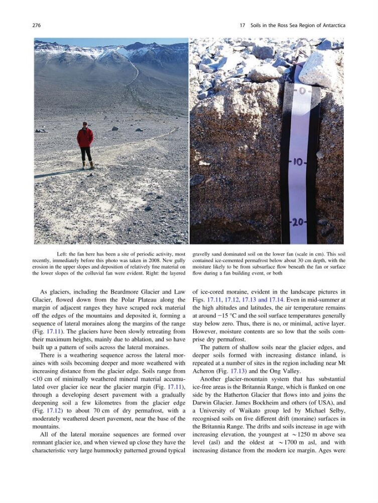
Fig. 17.9 Left: the fan here has been a site of periodic activity, most
recently, immediately before this photo was taken in 2008. New gully
erosion in the upper slopes and deposition of relatively fine material on
the lower slopes of the colluvial fan were evident. Right: the layered
gravelly sand dominated soil on the lower fan (scale in cm). This soil
contained ice-cemented permafrost below about 30 cm depth, with the
moisture likely to be from subsurface flow beneath the fan or surface
flow during a fan building event, or both
276
17 Soils in the Ross Sea Region of Antarctica
Glacier, flowed down from the Polar Plateau along the
margin of adjacent ranges they have scraped rock material
off the edges of the mountains and deposited it, forming a
sequence of lateral moraines along the margins of the range
(Fig. 17.11). The glaciers have been slowly retreating from
their maximum heights, mainly due to ablation, and so have
built up a pattern of soils across the lateral moraines.
There is a weathering sequence across the lateral moraines with soils becoming deeper and more weathered with
increasing distance from the glacier edge. Soils range from
<10 cm of minimally weathered mineral material accumulated over glacier ice near the glacier margin (Fig. 17.11),
through a developing desert pavement with a gradually
deepening soil a few kilometres from the glacier edge
(Fig. 17.12) to about 70 cm of dry permafrost, with a
moderately weathered desert pavement, near the base of the
mountains.
All of the lateral moraine sequences are formed over
remnant glacier ice, and when viewed up close they have the
characteristic very large hummocky patterned ground typical
of ice-cored moraine, evident in the landscape pictures in
Figs. 17.11, 17.12, 17.13 and 17.14. Even in mid-summer at
the high altitudes and latitudes, the air temperature remains
at around −15 °C and the soil surface temperatures generally
stay below zero. Thus, there is no, or minimal, active layer.
However, moisture contents are so low that the soils comprise dry permafrost.
The pattern of shallow soils near the glacier edges, and
deeper soils formed with increasing distance inland, is
repeated at a number of sites in the region including near Mt
Acheron (Fig. 17.13) and the Ong Valley.
Another glacier-mountain system that has substantial
ice-free areas is the Britannia Range, which is flanked on one
side by the Hatherton Glacier that flows into and joins the
Darwin Glacier. James Bockheim and others (of USA), and
a University of Waikato group led by Michael Selby,
recognised soils on five different drift (moraine) surfaces in
the Britannia Range. The drifts and soils increase in age with
increasing elevation, the youngest at *1250 m above sea
level (asl) and the oldest at *1700 m asl, and with
increasing distance from the modern ice margin. Ages were
Fig. 17.9 Left: the fan here has been a site of periodic activity, most
recently, immediately before this photo was taken in 2008. New gully
erosion in the upper slopes and deposition of relatively fine material on
the lower slopes of the colluvial fan were evident. Right: the layered
gravelly sand dominated soil on the lower fan (scale in cm). This soil
contained ice-cemented permafrost below about 30 cm depth, with the
moisture likely to be from subsurface flow beneath the fan or surface
flow during a fan building event, or both
276
17 Soils in the Ross Sea Region of Antarctica