

phase that formed the non-welded (loose) Taupo ignimbrite
(subunit Y6). The total volume of the Taupo eruptives is
about 35 km
3 as magma, equivalent to about 105 km
3 of bulk
pyroclastic material.
The fall deposits rained out over the landscape while being
blown more or less eastward towards Hawke’s Bay and
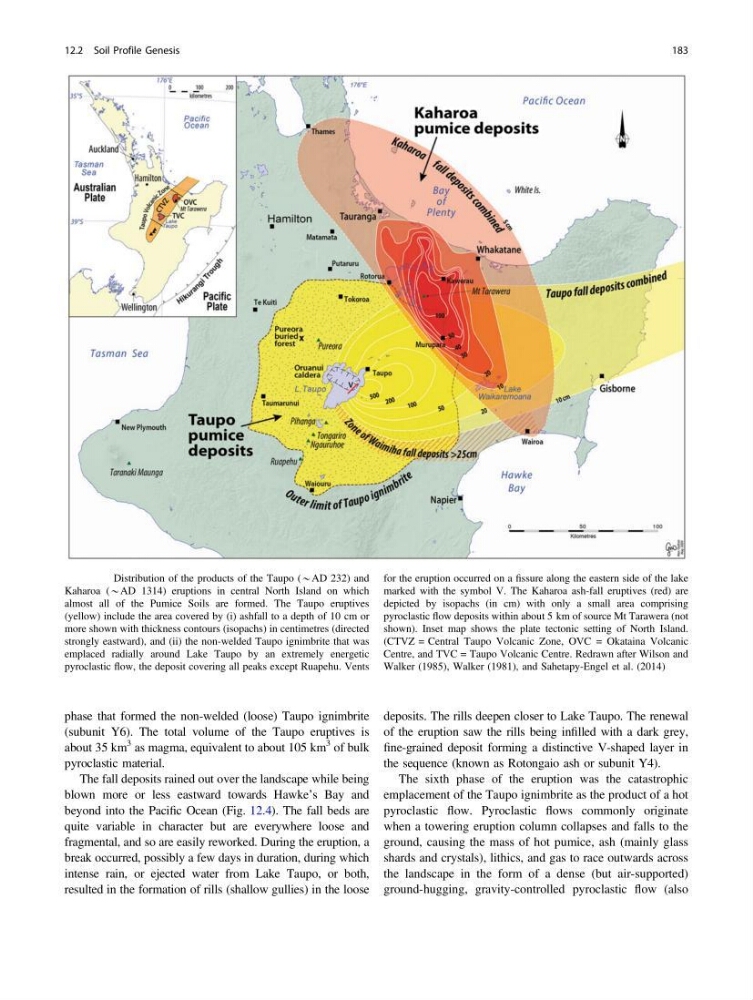
beyond into the Pacific Ocean (Fig. 12.4). The fall beds are
quite variable in character but are everywhere loose and
fragmental, and so are easily reworked. During the eruption, a
break occurred, possibly a few days in duration, during which
intense rain, or ejected water from Lake Taupo, or both,
resulted in the formation of rills (shallow gullies) in the loose
deposits. The rills deepen closer to Lake Taupo. The renewal
of the eruption saw the rills being infilled with a dark grey,
fine-grained deposit forming a distinctive V-shaped layer in
the sequence (known as Rotongaio ash or subunit Y4).
The sixth phase of the eruption was the catastrophic
emplacement of the Taupo ignimbrite as the product of a hot
pyroclastic flow. Pyroclastic flows commonly originate
when a towering eruption column collapses and falls to the
ground, causing the mass of hot pumice, ash (mainly glass
shards and crystals), lithics, and gas to race outwards across
the landscape in the form of a dense (but air-supported)
ground-hugging, gravity-controlled pyroclastic flow (also
Fig. 12.4 Distribution of the products of the Taupo (*AD 232) and
Kaharoa (*AD 1314) eruptions in central North Island on which
almost all of the Pumice Soils are formed. The Taupo eruptives
(yellow) include the area covered by (i) ashfall to a depth of 10 cm or
more shown with thickness contours (isopachs) in centimetres (directed
strongly eastward), and (ii) the non-welded Taupo ignimbrite that was
emplaced radially around Lake Taupo by an extremely energetic
pyroclastic flow, the deposit covering all peaks except Ruapehu. Vents
for the eruption occurred on a fissure along the eastern side of the lake
marked with the symbol V. The Kaharoa ash-fall eruptives (red) are
depicted by isopachs (in cm) with only a small area comprising
pyroclastic flow deposits within about 5 km of source Mt Tarawera (not
shown). Inset map shows the plate tectonic setting of North Island.
(CTVZ = Central Taupo Volcanic Zone, OVC = Okataina Volcanic
Centre, and TVC = Taupo Volcanic Centre. Redrawn after Wilson and
Walker (1985), Walker (1981), and Sahetapy-Engel et al. (2014)
12.2 Soil Profile Genesis
183
(subunit Y6). The total volume of the Taupo eruptives is
about 35 km
3 as magma, equivalent to about 105 km
3 of bulk
pyroclastic material.
The fall deposits rained out over the landscape while being
blown more or less eastward towards Hawke’s Bay and
beyond into the Pacific Ocean (Fig. 12.4). The fall beds are
quite variable in character but are everywhere loose and
fragmental, and so are easily reworked. During the eruption, a
break occurred, possibly a few days in duration, during which
intense rain, or ejected water from Lake Taupo, or both,
resulted in the formation of rills (shallow gullies) in the loose
deposits. The rills deepen closer to Lake Taupo. The renewal
of the eruption saw the rills being infilled with a dark grey,
fine-grained deposit forming a distinctive V-shaped layer in
the sequence (known as Rotongaio ash or subunit Y4).
The sixth phase of the eruption was the catastrophic
emplacement of the Taupo ignimbrite as the product of a hot
pyroclastic flow. Pyroclastic flows commonly originate
when a towering eruption column collapses and falls to the
ground, causing the mass of hot pumice, ash (mainly glass
shards and crystals), lithics, and gas to race outwards across
the landscape in the form of a dense (but air-supported)
ground-hugging, gravity-controlled pyroclastic flow (also
Fig. 12.4 Distribution of the products of the Taupo (*AD 232) and
Kaharoa (*AD 1314) eruptions in central North Island on which
almost all of the Pumice Soils are formed. The Taupo eruptives
(yellow) include the area covered by (i) ashfall to a depth of 10 cm or
more shown with thickness contours (isopachs) in centimetres (directed
strongly eastward), and (ii) the non-welded Taupo ignimbrite that was
emplaced radially around Lake Taupo by an extremely energetic
pyroclastic flow, the deposit covering all peaks except Ruapehu. Vents
for the eruption occurred on a fissure along the eastern side of the lake
marked with the symbol V. The Kaharoa ash-fall eruptives (red) are
depicted by isopachs (in cm) with only a small area comprising
pyroclastic flow deposits within about 5 km of source Mt Tarawera (not
shown). Inset map shows the plate tectonic setting of North Island.
(CTVZ = Central Taupo Volcanic Zone, OVC = Okataina Volcanic
Centre, and TVC = Taupo Volcanic Centre. Redrawn after Wilson and
Walker (1985), Walker (1981), and Sahetapy-Engel et al. (2014)
12.2 Soil Profile Genesis
183