

from Mt Tarawera (which forms the southern part of the
Okataina Volcanic Centre) (Fig. 12.4). Small areas of
Pumice Soils are formed in older rhyolitic pumice deposits
of the Waimihia eruption (erupted from Taupo volcano
about 3500 years ago) where they are preserved at the land
surface in northern Hawke’s Bay, and others are formed on
fluvially reworked pumice deposits on terraces alongside
rivers including the Waikato and Whanganui.
12.2.2 Magmatic Origins of Rhyolitic Pumice
Both the Taupo and Kaharoa eruptions, the most recent
rhyolitic events in New Zealand’s geological history, were
explosive, large-scale, events. Their sources were the Taupo
and Okataina Volcanic Centres, respectively, which are the
two most frequently-erupting and productive rhyolite volcanoes in the world. As the Pacific tectonic plate is subducted
beneath the North Island, which is located on the Australian
plate, it is heated and water and other fluids are boiled off and
stream into the mantle rocks beneath the island. The fluids
cause chemical changes that enable the otherwise solid rock
of the mantle to melt, forming basaltic magma. The magma
rises until it gets trapped beneath the continental crust of the
North Island. The very hot basalt magma acts like a huge
blow-torch, melting the crust and mixing with it to form
andesite magma (with SiO 2 *50–70 wt%), which is then
erupted as cone-shaped stratovolcanoes, such as Mt Ruapehu
and Taranaki Maunga. However, where further melting of the
continental crust occurs, extremely viscous rhyolite magma
forms in a magma chamber that may be only a few kilometres
beneath the ground. As magma rises to the surface, the drop
in pressure causes constituent gases (volatiles) to expand
violently, generating eruption columns of shattered magma
and rock fragments (lithics) and gases high into the upper
atmosphere, and even the stratosphere, before falling back to
the ground. The higher the pyroclastic materials (tephra) are
ejected, the farther from the volcano they will be carried by
the wind. In some cases, the explosive emptying of the
magma chamber results in the ground becoming unsupported
and so the land collapses, dropping like a piston, to form a
large depression or caldera. Nine large caldera volcanoes
including Taupo and Okataina (Fig. 12.4, inset) are concentrated in the central part of the Taupo Volcanic Zone. The
rhyolitic volcanoes erupt much greater volumes of magma
(both pyroclastics and lava), far less frequently, than the
eruptions from the andesitic volcanoes.
Taupo is regarded as the archetypal ‘inverse’
super-volcano in that most eruptions have been so explosive,
and dispersed material so widely, where the accumulation of
material around the vents has not compensated for collapse
associated with caldera formation. Consequently, the lake
bed is the lowest point in the landscape for over 40 km in
any direction. The Okataina Volcanic Centre, in which Mt
Tarawera forms the southern part, comprises a caldera that
has been partly infilled with numerous lava flows and domes
and so has a greater relief than the Taupo Volcanic Centre.
12.2.3 Taupo Eruption and Its Products
The Taupo eruption took place in AD 232 ± 10 (see grey
box for age details) and was the 27th eruption to have taken
place in the Taupo Volcanic Centre (which includes Lake
Taupo) since the Oruanui super-eruption occurred about
25,400 years ago. The Oruanui (also known as Kawakawa)
eruption was extremely voluminous with a total magma
volume of *530 km
3 (equivalent to 1170 km
3 as bulk
pyroclastic material). Caldera collapse associated with the
Oruanui eruption generated the wide basin that forms the
northern half of Lake Taupo today (Fig. 12.4).
The Taupo eruption in *AD 232 (unit Y in the
post-Oruanui eruption sequence, Fig. 12.5) was one of the
most violent and complex rhyolite eruptions in the world in
the past 5000 years. The eruption was centred on at least three
vents near the Horomatangi Reefs under the waters of eastern
Lake Taupo. It consisted of five explosive phases, both ‘wet’
(involving magma-water interactions, i.e. phreatomagmatic)
and ‘dry’ (driven by the expansion of internal volatiles, i.e.
magmatic), which deposited pyroclastic fall deposits (subunits
Y1–Y5, Fig. 12.5), followed by the sixth and climactic final
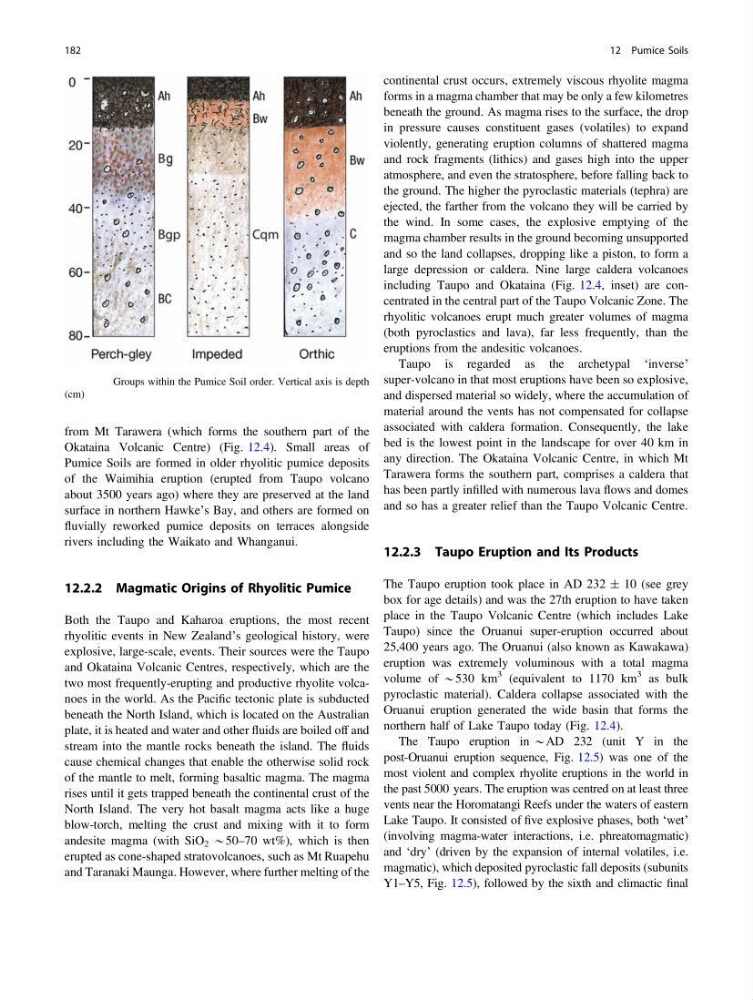
Fig. 12.3 Groups within the Pumice Soil order. Vertical axis is depth
(cm)
182
12 Pumice Soils
Okataina Volcanic Centre) (Fig. 12.4). Small areas of
Pumice Soils are formed in older rhyolitic pumice deposits
of the Waimihia eruption (erupted from Taupo volcano
about 3500 years ago) where they are preserved at the land
surface in northern Hawke’s Bay, and others are formed on
fluvially reworked pumice deposits on terraces alongside
rivers including the Waikato and Whanganui.
12.2.2 Magmatic Origins of Rhyolitic Pumice
Both the Taupo and Kaharoa eruptions, the most recent
rhyolitic events in New Zealand’s geological history, were
explosive, large-scale, events. Their sources were the Taupo
and Okataina Volcanic Centres, respectively, which are the
two most frequently-erupting and productive rhyolite volcanoes in the world. As the Pacific tectonic plate is subducted
beneath the North Island, which is located on the Australian
plate, it is heated and water and other fluids are boiled off and
stream into the mantle rocks beneath the island. The fluids
cause chemical changes that enable the otherwise solid rock
of the mantle to melt, forming basaltic magma. The magma
rises until it gets trapped beneath the continental crust of the
North Island. The very hot basalt magma acts like a huge
blow-torch, melting the crust and mixing with it to form
andesite magma (with SiO 2 *50–70 wt%), which is then
erupted as cone-shaped stratovolcanoes, such as Mt Ruapehu
and Taranaki Maunga. However, where further melting of the
continental crust occurs, extremely viscous rhyolite magma
forms in a magma chamber that may be only a few kilometres
beneath the ground. As magma rises to the surface, the drop
in pressure causes constituent gases (volatiles) to expand
violently, generating eruption columns of shattered magma
and rock fragments (lithics) and gases high into the upper
atmosphere, and even the stratosphere, before falling back to
the ground. The higher the pyroclastic materials (tephra) are
ejected, the farther from the volcano they will be carried by
the wind. In some cases, the explosive emptying of the
magma chamber results in the ground becoming unsupported
and so the land collapses, dropping like a piston, to form a
large depression or caldera. Nine large caldera volcanoes
including Taupo and Okataina (Fig. 12.4, inset) are concentrated in the central part of the Taupo Volcanic Zone. The
rhyolitic volcanoes erupt much greater volumes of magma
(both pyroclastics and lava), far less frequently, than the
eruptions from the andesitic volcanoes.
Taupo is regarded as the archetypal ‘inverse’
super-volcano in that most eruptions have been so explosive,
and dispersed material so widely, where the accumulation of
material around the vents has not compensated for collapse
associated with caldera formation. Consequently, the lake
bed is the lowest point in the landscape for over 40 km in
any direction. The Okataina Volcanic Centre, in which Mt
Tarawera forms the southern part, comprises a caldera that
has been partly infilled with numerous lava flows and domes
and so has a greater relief than the Taupo Volcanic Centre.
12.2.3 Taupo Eruption and Its Products
The Taupo eruption took place in AD 232 ± 10 (see grey
box for age details) and was the 27th eruption to have taken
place in the Taupo Volcanic Centre (which includes Lake
Taupo) since the Oruanui super-eruption occurred about
25,400 years ago. The Oruanui (also known as Kawakawa)
eruption was extremely voluminous with a total magma
volume of *530 km
3 (equivalent to 1170 km
3 as bulk
pyroclastic material). Caldera collapse associated with the
Oruanui eruption generated the wide basin that forms the
northern half of Lake Taupo today (Fig. 12.4).
The Taupo eruption in *AD 232 (unit Y in the
post-Oruanui eruption sequence, Fig. 12.5) was one of the
most violent and complex rhyolite eruptions in the world in
the past 5000 years. The eruption was centred on at least three
vents near the Horomatangi Reefs under the waters of eastern
Lake Taupo. It consisted of five explosive phases, both ‘wet’
(involving magma-water interactions, i.e. phreatomagmatic)
and ‘dry’ (driven by the expansion of internal volatiles, i.e.
magmatic), which deposited pyroclastic fall deposits (subunits
Y1–Y5, Fig. 12.5), followed by the sixth and climactic final
Fig. 12.3 Groups within the Pumice Soil order. Vertical axis is depth
(cm)
182
12 Pumice Soils