

8.3.3 The Waihola-Waipori Wetland system—a
Glimpse of the Taieri Plain in Pre-Human
Times
The Waihola-Waipori wetland system comprises Lakes
Waihola and Waipori and associated wetlands at the
southern end of the Taieri Plain in Otago. It features the open
waters of the two main lakes, many small lakes and extensive wetland areas. Active sedimentary inputs come from the
Taieri and Waipori rivers forming deltas at the entrance to
the wetlands (Fig. 8.8). The area is tidal with fluctuating
water levels controlled by the tidal influence of a connection
to the ocean through the Waihola gorge. The area comprises
a complex system of rivers, lakes, tides, shifting sediment,
lake-margin flora, organic infill of swamps, fluvial erosion,
deltaic sedimentation, and an array of habitats where wetland
plants thrive and accumulate organic matter. The variation is
driven by river volume and velocity which control the sediment passing through the system. The relatively quiet
backwaters sustain a rich biodiversity and an outdoor ‘laboratory’ of wetland processes.
Organic Soils are formed in back swamp areas where
organic matter has accumulated with occasional inputs of
alluvial material during floods. The soils are predominantly
Mellow Fibric Organic Soils formed in materials derived
mainly from sedges (Carex secta) and flax (Phormium
tenax). In areas that have been subject to previous attempts
at drainage and farming, the soils are more strongly
decomposed and Mellow Humic Organic Soils occur. In
some of the previously farmed (in the 1940s) areas, the peat
was biodegraded and paddock-shaped shallow lakes remain
(Fig. 8.8). Most areas of peat overlie unconsolidated
lake-bed sediments at 1–2 m depth. Where less than 30 cm
of organic material has accumulated, the soils are Raw Soils
if the sediments remain fluid, Gley Soils if the material is
consolidated and reducing conditions predominate, or
Recent Soils on the wetland margins and higher parts of the
levees.
Further up the Taieri Plain, where the Silver Stream
adjoins the Taieri River, is a shallow basin with an area of
Organic Soils that has been developed for farming. At the
central topographic low point of this basin is an extensive
area of deep Acidic Mesic Organic Soils. At its southern
margin, loamy flood deposits have spilled over from the
Taieri River (Fluvial Recent Gley Soils) partly burying the
Organic Soils. At its northern margin, the organic layer thins
to the point that it can no longer qualify as an Organic Soil
and instead is a Recent Soil with a peaty topsoil. In this area
and further north on the Taieri plain (Chap. 14), the alluvial
deposits indicate deposition by deltaic fluvial sedimentation.
It is tempting to view the current Waihola-Waipori wetlands, and variation in plant and hydro-sedimentary systems,
observed in the southern end of the Taieri, as glimpses of the
former deltaic lacustrine environment of the mid and
northern Taieri Plain long before human occupation.
8.3.4 Southern Sphagnum Wetlands
of the Lammerlaw Range, East Otago
The Lammerlaw Range and other similar ranges of the east
Otago tussock grassland plateau have extensive
sphagnum-dominated wetlands comprising Acidic Mesic
Organic Soils draped, like a blanket, over the broad ridges
and plateaux of the easy rolling uplands (above 500 m
altitude). The landforms are recognised as bogs because for
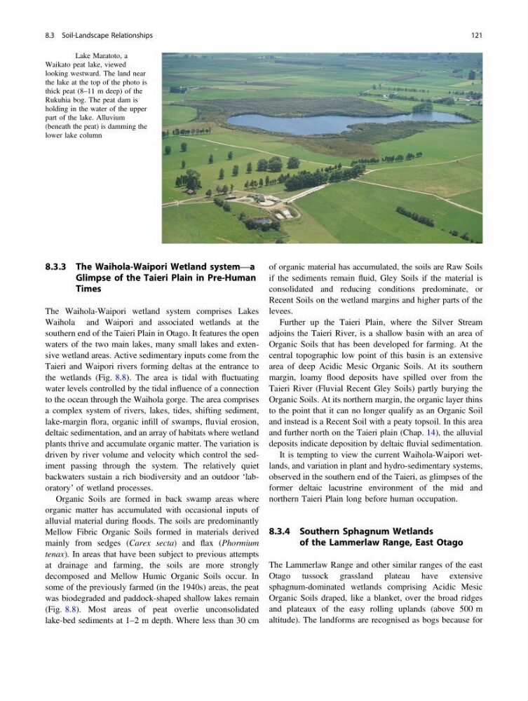
Fig. 8.7 Lake Maratoto, a
Waikato peat lake, viewed
looking westward. The land near
the lake at the top of the photo is
thick peat (8–11 m deep) of the
Rukuhia bog. The peat dam is
holding in the water of the upper
part of the lake. Alluvium
(beneath the peat) is damming the
lower lake column
8.3 Soil-Landscape Relationships
121
Glimpse of the Taieri Plain in Pre-Human
Times
The Waihola-Waipori wetland system comprises Lakes
Waihola and Waipori and associated wetlands at the
southern end of the Taieri Plain in Otago. It features the open
waters of the two main lakes, many small lakes and extensive wetland areas. Active sedimentary inputs come from the
Taieri and Waipori rivers forming deltas at the entrance to
the wetlands (Fig. 8.8). The area is tidal with fluctuating
water levels controlled by the tidal influence of a connection
to the ocean through the Waihola gorge. The area comprises
a complex system of rivers, lakes, tides, shifting sediment,
lake-margin flora, organic infill of swamps, fluvial erosion,
deltaic sedimentation, and an array of habitats where wetland
plants thrive and accumulate organic matter. The variation is
driven by river volume and velocity which control the sediment passing through the system. The relatively quiet
backwaters sustain a rich biodiversity and an outdoor ‘laboratory’ of wetland processes.
Organic Soils are formed in back swamp areas where
organic matter has accumulated with occasional inputs of
alluvial material during floods. The soils are predominantly
Mellow Fibric Organic Soils formed in materials derived
mainly from sedges (Carex secta) and flax (Phormium
tenax). In areas that have been subject to previous attempts
at drainage and farming, the soils are more strongly
decomposed and Mellow Humic Organic Soils occur. In
some of the previously farmed (in the 1940s) areas, the peat
was biodegraded and paddock-shaped shallow lakes remain
(Fig. 8.8). Most areas of peat overlie unconsolidated
lake-bed sediments at 1–2 m depth. Where less than 30 cm
of organic material has accumulated, the soils are Raw Soils
if the sediments remain fluid, Gley Soils if the material is
consolidated and reducing conditions predominate, or
Recent Soils on the wetland margins and higher parts of the
levees.
Further up the Taieri Plain, where the Silver Stream
adjoins the Taieri River, is a shallow basin with an area of
Organic Soils that has been developed for farming. At the
central topographic low point of this basin is an extensive
area of deep Acidic Mesic Organic Soils. At its southern
margin, loamy flood deposits have spilled over from the
Taieri River (Fluvial Recent Gley Soils) partly burying the
Organic Soils. At its northern margin, the organic layer thins
to the point that it can no longer qualify as an Organic Soil
and instead is a Recent Soil with a peaty topsoil. In this area
and further north on the Taieri plain (Chap. 14), the alluvial
deposits indicate deposition by deltaic fluvial sedimentation.
It is tempting to view the current Waihola-Waipori wetlands, and variation in plant and hydro-sedimentary systems,
observed in the southern end of the Taieri, as glimpses of the
former deltaic lacustrine environment of the mid and
northern Taieri Plain long before human occupation.
8.3.4 Southern Sphagnum Wetlands
of the Lammerlaw Range, East Otago
The Lammerlaw Range and other similar ranges of the east
Otago tussock grassland plateau have extensive
sphagnum-dominated wetlands comprising Acidic Mesic
Organic Soils draped, like a blanket, over the broad ridges
and plateaux of the easy rolling uplands (above 500 m
altitude). The landforms are recognised as bogs because for
Fig. 8.7 Lake Maratoto, a
Waikato peat lake, viewed
looking westward. The land near
the lake at the top of the photo is
thick peat (8–11 m deep) of the
Rukuhia bog. The peat dam is
holding in the water of the upper
part of the lake. Alluvium
(beneath the peat) is damming the
lower lake column
8.3 Soil-Landscape Relationships
121