

flowing via the Matamata-Hauraki lowlands into the Pacific
Ocean. However, following the Oruanui super-eruption of
Taupo volcano c. 25,400 years ago, which generated huge
volumes of loose pyroclastic materials that were then
reworked by the choked Waikato River, sediment built up at
Piarere. Eventually, several thousand years after the eruption, the river was forced to switch course, c. 23,500 years
ago, at Piarere and flow into the Hamilton lowlands (and out
to the Tasman Sea). Thus much of the alluvium carried into
the Hamilton lowlands was derived from the reworked
Oruanui eruptives, referred to as ‘volcanogenic’. At the
coldest point of the last glacial maximum, the ancestral
Waikato River (at that time a high energy, braided river
system) gradually infilled the Hamilton lowlands with the
volcanogenic gravels and sands (Hinuera Formation), partly
burying the hills and damming drainage from the valleys,
and forming an extensive plain.
The thick sediments acted as small dams, generating
small basins into which drainage from the hills then formed
lakes. A series of around 30 lakes (many now surrounded by
peat) formed on the margins of the low hills within the
Hamilton lowlands. Most of the lakes formed about
20,000 years ago. Hence the lakes are most accurately
described as riverine in origin.
Peat then began forming in scattered low-lying swampy
hollows on the surface of Hinuera sediments, and around the
margins of many of the lakes. From about 13,000 years ago
net rainfall increased markedly and the regional water tables
rose (accelerating from c. 8000 years ago) so that the scattered peats rapidly expanded, coalescing to form large bogs,
including Rukuhia and Moanatuatua. Peat growth around
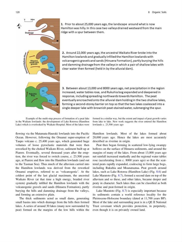
lakes, such as Lake Rotoroa (Hamilton Lake) (Fig. 8.6) and
Lake Maratoto (Fig. 8.7), formed a second dam on top of the
alluvium and so these, and other lakes, became deeper and
peaty in character. Such lakes thus can be classified as both
riverine and peat-formed in origin.
Lake Maratoto (Fig. 8.7) is especially important because
its sediments contain a world reference locality for the
Pleistocene-Holocene boundary (dated at 11,700 years BP).
Most of the lake and surrounding peat is in a QE II National
Trust covenant which provides protection, in perpetuity,
even though it is on privately owned land.
Fig. 8.6 Example of the multi-step process of formation of a peat lake
in the Waikato lowlands: the development of Lake Rotoroa (Hamilton
Lake) which is overlooked by Waikato Hospital. Most of the lakes were
formed in a similar way, but the extent and impact of peat growth varies
from lake to lake. New work suggests the river entered the Hamilton
lowlands c. 23,500 years ago
120
8 Organic Soils
Ocean. However, following the Oruanui super-eruption of
Taupo volcano c. 25,400 years ago, which generated huge
volumes of loose pyroclastic materials that were then
reworked by the choked Waikato River, sediment built up at
Piarere. Eventually, several thousand years after the eruption, the river was forced to switch course, c. 23,500 years
ago, at Piarere and flow into the Hamilton lowlands (and out
to the Tasman Sea). Thus much of the alluvium carried into
the Hamilton lowlands was derived from the reworked
Oruanui eruptives, referred to as ‘volcanogenic’. At the
coldest point of the last glacial maximum, the ancestral
Waikato River (at that time a high energy, braided river
system) gradually infilled the Hamilton lowlands with the
volcanogenic gravels and sands (Hinuera Formation), partly
burying the hills and damming drainage from the valleys,
and forming an extensive plain.
The thick sediments acted as small dams, generating
small basins into which drainage from the hills then formed
lakes. A series of around 30 lakes (many now surrounded by
peat) formed on the margins of the low hills within the
Hamilton lowlands. Most of the lakes formed about
20,000 years ago. Hence the lakes are most accurately
described as riverine in origin.
Peat then began forming in scattered low-lying swampy
hollows on the surface of Hinuera sediments, and around the
margins of many of the lakes. From about 13,000 years ago
net rainfall increased markedly and the regional water tables
rose (accelerating from c. 8000 years ago) so that the scattered peats rapidly expanded, coalescing to form large bogs,
including Rukuhia and Moanatuatua. Peat growth around
lakes, such as Lake Rotoroa (Hamilton Lake) (Fig. 8.6) and
Lake Maratoto (Fig. 8.7), formed a second dam on top of the
alluvium and so these, and other lakes, became deeper and
peaty in character. Such lakes thus can be classified as both
riverine and peat-formed in origin.
Lake Maratoto (Fig. 8.7) is especially important because
its sediments contain a world reference locality for the
Pleistocene-Holocene boundary (dated at 11,700 years BP).
Most of the lake and surrounding peat is in a QE II National
Trust covenant which provides protection, in perpetuity,
even though it is on privately owned land.
Fig. 8.6 Example of the multi-step process of formation of a peat lake
in the Waikato lowlands: the development of Lake Rotoroa (Hamilton
Lake) which is overlooked by Waikato Hospital. Most of the lakes were
formed in a similar way, but the extent and impact of peat growth varies
from lake to lake. New work suggests the river entered the Hamilton
lowlands c. 23,500 years ago
120
8 Organic Soils