

P
50° N parallel
(Latit ude)
Equator
W
E
P ri m e m e ri d ia n
N
S
60 °W m er id ia n
(Lo ng itu d e)
longitudes correspond to values of φ less than 0° or greater than
180°. Thus a point at (10°S, 110°W) has θ = 90° + 10° = 100°,
and φ = −110° = 360° − 110° = 250°.
At any point, unit spherical basis vectors (ê r , ê θ , ê φ ) can be
defined in the direction of increasing r, θ, and φ. ê r points away
from the origin, and gives the upward vertical direction. ê θ
points south, and ê φ points east. These two are sometimes written in terms of north- and east-pointing unit vectors, ê NS = −ê θ
and ê EW = ê φ .
An important feature of the unit spherical basis vectors is
that at different points they are oriented differently with respect to the Cartesian axes. The Cartesian unit basis vectors
(ê 1 , ê 2 , ê 3 ) point in the same direction everywhere. By contrast,
for example, ê r points in the ê 3 direction at the north pole, and
in the −ê 3 direction at the south pole. This effect is described by
the Cartesian (ê 1 , ê 2 , ê 3 ) components of the unit spherical basis
vectors, at a point with colatitude θ and longitude φ :
ê
ê
ê
φ
θ
φ
φ
θ
φ
θ
φ
θ
θ
φ
θ
φ
θ
sin
cos ,
cos cos
cos sin
sin
,
sin cos
sin sin
cos
.
=
−
⎛
⎝
⎜
⎜
⎞
⎠
⎟
⎟
=
−
⎛
⎝
⎜
⎜
⎞
⎠
⎟
⎟
=
⎛
⎝
⎜
⎜
⎞
⎠
⎟
⎟
0
r
(4)
The dependence on the colatitude and longitude describes how
the orientation with respect to the Cartesian axes changes.
At any point, the spherical basis vectors (ê r , ê θ , ê φ ) form an
orthonormal set. For problems whose spatial extent is small
enough that the curvature of the earth can be ignored, these
basis vectors provide a useful local coordinate system.
A.7.2 Distance and azimuth
Spherical coordinates are especially useful in describing the
geographic relation between two points on the earth’s surface.
A common application is to find the distance between points
and the direction of the great circle arc joining them. A great
circle arc is the shortest path between points on a sphere, so if
seismic velocity varies only with depth, the fastest path along
the surface is the great circle arc, and the fastest paths through
the interior are in the plane of the great circle and the center
of the earth. Because velocities vary laterally by only a few
percent throughout most of the earth (and imperceptibly in
the liquid outer core), this is a good approximation for most
seismic applications. The source-to-receiver distance is often
given in terms of the angle ∆ subtended at the center of the earth
by the great circle arc between the two points (Fig. A.7-3). If
∆ is expressed in radians, then the length s (in km) of the arc
along the earth’s surface is R∆, where R is the earth’s radius
(≈ 6371 km). If ∆ is expressed in degrees, s = R∆π/180, so one
degree of arc equals 111.2 km.
Consider the great circle arc connecting an earthquake
whose epicenter is at (θ E , φ E ) and a seismic station at (θ S , φ S ).
Seismic waves that traveled along the great circle arc (or in the
plane of this arc and the center of the earth) left the earthquake
in a direction given by the azimuth angle ζ measured clockwise
from the local direction of north at the epicenter to the great
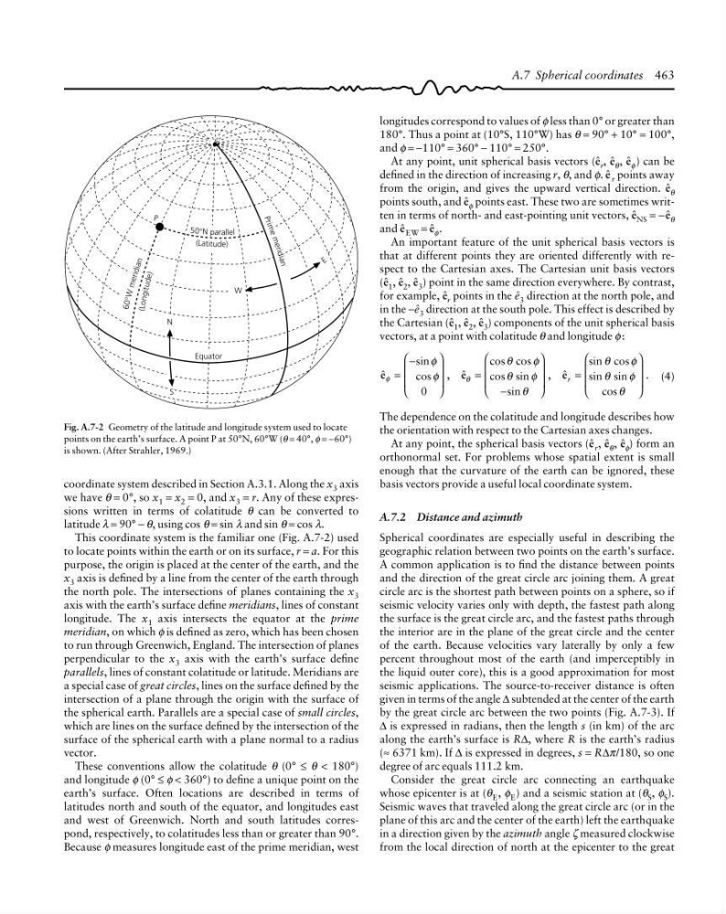
Fig. A.7-2 Geometry of the latitude and longitude system used to locate
points on the earth’s surface. A point P at 50°N, 60°W (θ = 40°, φ = −60°)
is shown. (After Strahler, 1969.)
coordinate system described in Section A.3.1. Along the x 3 axis
we have θ = 0°, so x 1 = x 2 = 0, and x 3 = r. Any of these expressions written in terms of colatitude θ can be converted to
latitude λ = 90° − θ, using cos θ = sin λ and sin θ = cos λ.
This coordinate system is the familiar one (Fig. A.7-2) used
to locate points within the earth or on its surface, r = a. For this
purpose, the origin is placed at the center of the earth, and the
x 3 axis is defined by a line from the center of the earth through
the north pole. The intersections of planes containing the x 3
axis with the earth’s surface define meridians, lines of constant
longitude. The x 1 axis intersects the equator at the prime
meridian, on which φ is defined as zero, which has been chosen
to run through Greenwich, England. The intersection of planes
perpendicular to the x 3 axis with the earth’s surface define
parallels, lines of constant colatitude or latitude. Meridians are
a special case of great circles, lines on the surface defined by the
intersection of a plane through the origin with the surface of
the spherical earth. Parallels are a special case of small circles,
which are lines on the surface defined by the intersection of the
surface of the spherical earth with a plane normal to a radius
vector.
These conventions allow the colatitude θ (0° ≤ θ < 180°)
and longitude φ (0° ≤ φ < 360°) to define a unique point on the
earth’s surface. Often locations are described in terms of
latitudes north and south of the equator, and longitudes east
and west of Greenwich. North and south latitudes correspond, respectively, to colatitudes less than or greater than 90°.
Because φ measures longitude east of the prime meridian, west
A.7 Spherical coordinates 463
50° N parallel
(Latit ude)
Equator
W
E
P ri m e m e ri d ia n
N
S
60 °W m er id ia n
(Lo ng itu d e)
longitudes correspond to values of φ less than 0° or greater than
180°. Thus a point at (10°S, 110°W) has θ = 90° + 10° = 100°,
and φ = −110° = 360° − 110° = 250°.
At any point, unit spherical basis vectors (ê r , ê θ , ê φ ) can be
defined in the direction of increasing r, θ, and φ. ê r points away
from the origin, and gives the upward vertical direction. ê θ
points south, and ê φ points east. These two are sometimes written in terms of north- and east-pointing unit vectors, ê NS = −ê θ
and ê EW = ê φ .
An important feature of the unit spherical basis vectors is
that at different points they are oriented differently with respect to the Cartesian axes. The Cartesian unit basis vectors
(ê 1 , ê 2 , ê 3 ) point in the same direction everywhere. By contrast,
for example, ê r points in the ê 3 direction at the north pole, and
in the −ê 3 direction at the south pole. This effect is described by
the Cartesian (ê 1 , ê 2 , ê 3 ) components of the unit spherical basis
vectors, at a point with colatitude θ and longitude φ :
ê
ê
ê
φ
θ
φ
φ
θ
φ
θ
φ
θ
θ
φ
θ
φ
θ
sin
cos ,
cos cos
cos sin
sin
,
sin cos
sin sin
cos
.
=
−
⎛
⎝
⎜
⎜
⎞
⎠
⎟
⎟
=
−
⎛
⎝
⎜
⎜
⎞
⎠
⎟
⎟
=
⎛
⎝
⎜
⎜
⎞
⎠
⎟
⎟
0
r
(4)
The dependence on the colatitude and longitude describes how
the orientation with respect to the Cartesian axes changes.
At any point, the spherical basis vectors (ê r , ê θ , ê φ ) form an
orthonormal set. For problems whose spatial extent is small
enough that the curvature of the earth can be ignored, these
basis vectors provide a useful local coordinate system.
A.7.2 Distance and azimuth
Spherical coordinates are especially useful in describing the
geographic relation between two points on the earth’s surface.
A common application is to find the distance between points
and the direction of the great circle arc joining them. A great
circle arc is the shortest path between points on a sphere, so if
seismic velocity varies only with depth, the fastest path along
the surface is the great circle arc, and the fastest paths through
the interior are in the plane of the great circle and the center
of the earth. Because velocities vary laterally by only a few
percent throughout most of the earth (and imperceptibly in
the liquid outer core), this is a good approximation for most
seismic applications. The source-to-receiver distance is often
given in terms of the angle ∆ subtended at the center of the earth
by the great circle arc between the two points (Fig. A.7-3). If
∆ is expressed in radians, then the length s (in km) of the arc
along the earth’s surface is R∆, where R is the earth’s radius
(≈ 6371 km). If ∆ is expressed in degrees, s = R∆π/180, so one
degree of arc equals 111.2 km.
Consider the great circle arc connecting an earthquake
whose epicenter is at (θ E , φ E ) and a seismic station at (θ S , φ S ).
Seismic waves that traveled along the great circle arc (or in the
plane of this arc and the center of the earth) left the earthquake
in a direction given by the azimuth angle ζ measured clockwise
from the local direction of north at the epicenter to the great
Fig. A.7-2 Geometry of the latitude and longitude system used to locate
points on the earth’s surface. A point P at 50°N, 60°W (θ = 40°, φ = −60°)
is shown. (After Strahler, 1969.)
coordinate system described in Section A.3.1. Along the x 3 axis
we have θ = 0°, so x 1 = x 2 = 0, and x 3 = r. Any of these expressions written in terms of colatitude θ can be converted to
latitude λ = 90° − θ, using cos θ = sin λ and sin θ = cos λ.
This coordinate system is the familiar one (Fig. A.7-2) used
to locate points within the earth or on its surface, r = a. For this
purpose, the origin is placed at the center of the earth, and the
x 3 axis is defined by a line from the center of the earth through
the north pole. The intersections of planes containing the x 3
axis with the earth’s surface define meridians, lines of constant
longitude. The x 1 axis intersects the equator at the prime
meridian, on which φ is defined as zero, which has been chosen
to run through Greenwich, England. The intersection of planes
perpendicular to the x 3 axis with the earth’s surface define
parallels, lines of constant colatitude or latitude. Meridians are
a special case of great circles, lines on the surface defined by the
intersection of a plane through the origin with the surface of
the spherical earth. Parallels are a special case of small circles,
which are lines on the surface defined by the intersection of the
surface of the spherical earth with a plane normal to a radius
vector.
These conventions allow the colatitude θ (0° ≤ θ < 180°)
and longitude φ (0° ≤ φ < 360°) to define a unique point on the
earth’s surface. Often locations are described in terms of
latitudes north and south of the equator, and longitudes east
and west of Greenwich. North and south latitudes correspond, respectively, to colatitudes less than or greater than 90°.
Because φ measures longitude east of the prime meridian, west
A.7 Spherical coordinates 463