

342 Seismology and Plate Tectonics
15°
20°
25°S
G P S N Z − S A
N U V E L 1 A
GPS data
10 Ma to present
15°
20°
25°S
100 mm/yr
70°
75°
65°W
70°
75°
65°W
4 The similarity of the focal mechanism, GPS, and geological data illustrates the
principle of uniformitarianism, that studying present processes gives insight into the
past, a tenet of geology since Lyell and Hutton’s seminal work almost two centuries ago.
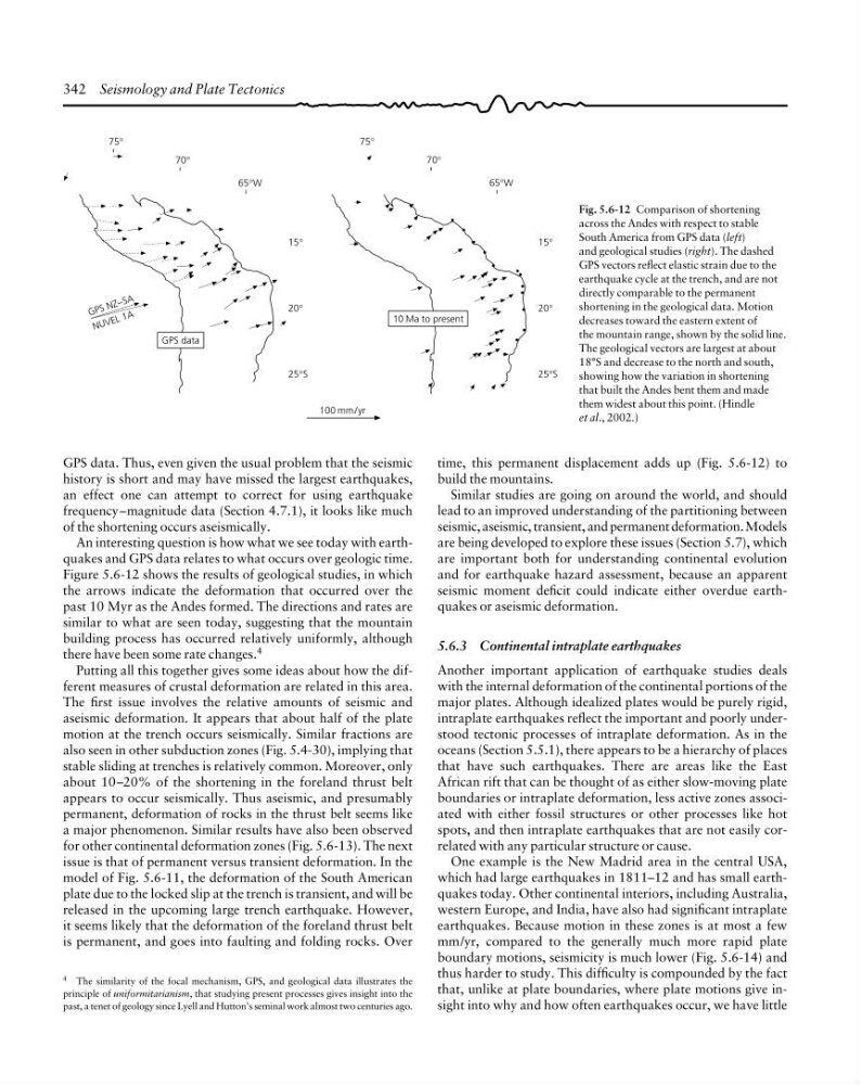
Fig. 5.6-12 Comparison of shortening
across the Andes with respect to stable
South America from GPS data (left)
and geological studies (right). The dashed
GPS vectors reflect elastic strain due to the
earthquake cycle at the trench, and are not
directly comparable to the permanent
shortening in the geological data. Motion
decreases toward the eastern extent of
the mountain range, shown by the solid line.
The geological vectors are largest at about
18°S and decrease to the north and south,
showing how the variation in shortening
that built the Andes bent them and made
them widest about this point. (Hindle
et al., 2002.)
GPS data. Thus, even given the usual problem that the seismic
history is short and may have missed the largest earthquakes,
an effect one can attempt to correct for using earthquake
frequency–magnitude data (Section 4.7.1), it looks like much
of the shortening occurs aseismically.
An interesting question is how what we see today with earthquakes and GPS data relates to what occurs over geologic time.
Figure 5.6-12 shows the results of geological studies, in which
the arrows indicate the deformation that occurred over the
past 10 Myr as the Andes formed. The directions and rates are
similar to what are seen today, suggesting that the mountain
building process has occurred relatively uniformly, although
there have been some rate changes. 4
Putting all this together gives some ideas about how the different measures of crustal deformation are related in this area.
The first issue involves the relative amounts of seismic and
aseismic deformation. It appears that about half of the plate
motion at the trench occurs seismically. Similar fractions are
also seen in other subduction zones (Fig. 5.4-30), implying that
stable sliding at trenches is relatively common. Moreover, only
about 10–20% of the shortening in the foreland thrust belt
appears to occur seismically. Thus aseismic, and presumably
permanent, deformation of rocks in the thrust belt seems like
a major phenomenon. Similar results have also been observed
for other continental deformation zones (Fig. 5.6-13). The next
issue is that of permanent versus transient deformation. In the
model of Fig. 5.6-11, the deformation of the South American
plate due to the locked slip at the trench is transient, and will be
released in the upcoming large trench earthquake. However,
it seems likely that the deformation of the foreland thrust belt
is permanent, and goes into faulting and folding rocks. Over
time, this permanent displacement adds up (Fig. 5.6-12) to
build the mountains.
Similar studies are going on around the world, and should
lead to an improved understanding of the partitioning between
seismic, aseismic, transient, and permanent deformation. Models
are being developed to explore these issues (Section 5.7), which
are important both for understanding continental evolution
and for earthquake hazard assessment, because an apparent
seismic moment deficit could indicate either overdue earthquakes or aseismic deformation.
5.6.3 Continental intraplate earthquakes
Another important application of earthquake studies deals
with the internal deformation of the continental portions of the
major plates. Although idealized plates would be purely rigid,
intraplate earthquakes reflect the important and poorly understood tectonic processes of intraplate deformation. As in the
oceans (Section 5.5.1), there appears to be a hierarchy of places
that have such earthquakes. There are areas like the East
African rift that can be thought of as either slow-moving plate
boundaries or intraplate deformation, less active zones associated with either fossil structures or other processes like hot
spots, and then intraplate earthquakes that are not easily correlated with any particular structure or cause.
One example is the New Madrid area in the central USA,
which had large earthquakes in 1811–12 and has small earthquakes today. Other continental interiors, including Australia,
western Europe, and India, have also had significant intraplate
earthquakes. Because motion in these zones is at most a few
mm/yr, compared to the generally much more rapid plate
boundary motions, seismicity is much lower (Fig. 5.6-14) and
thus harder to study. This difficulty is compounded by the fact
that, unlike at plate boundaries, where plate motions give insight into why and how often earthquakes occur, we have little
15°
20°
25°S
G P S N Z − S A
N U V E L 1 A
GPS data
10 Ma to present
15°
20°
25°S
100 mm/yr
70°
75°
65°W
70°
75°
65°W
4 The similarity of the focal mechanism, GPS, and geological data illustrates the
principle of uniformitarianism, that studying present processes gives insight into the
past, a tenet of geology since Lyell and Hutton’s seminal work almost two centuries ago.
Fig. 5.6-12 Comparison of shortening
across the Andes with respect to stable
South America from GPS data (left)
and geological studies (right). The dashed
GPS vectors reflect elastic strain due to the
earthquake cycle at the trench, and are not
directly comparable to the permanent
shortening in the geological data. Motion
decreases toward the eastern extent of
the mountain range, shown by the solid line.
The geological vectors are largest at about
18°S and decrease to the north and south,
showing how the variation in shortening
that built the Andes bent them and made
them widest about this point. (Hindle
et al., 2002.)
GPS data. Thus, even given the usual problem that the seismic
history is short and may have missed the largest earthquakes,
an effect one can attempt to correct for using earthquake
frequency–magnitude data (Section 4.7.1), it looks like much
of the shortening occurs aseismically.
An interesting question is how what we see today with earthquakes and GPS data relates to what occurs over geologic time.
Figure 5.6-12 shows the results of geological studies, in which
the arrows indicate the deformation that occurred over the
past 10 Myr as the Andes formed. The directions and rates are
similar to what are seen today, suggesting that the mountain
building process has occurred relatively uniformly, although
there have been some rate changes. 4
Putting all this together gives some ideas about how the different measures of crustal deformation are related in this area.
The first issue involves the relative amounts of seismic and
aseismic deformation. It appears that about half of the plate
motion at the trench occurs seismically. Similar fractions are
also seen in other subduction zones (Fig. 5.4-30), implying that
stable sliding at trenches is relatively common. Moreover, only
about 10–20% of the shortening in the foreland thrust belt
appears to occur seismically. Thus aseismic, and presumably
permanent, deformation of rocks in the thrust belt seems like
a major phenomenon. Similar results have also been observed
for other continental deformation zones (Fig. 5.6-13). The next
issue is that of permanent versus transient deformation. In the
model of Fig. 5.6-11, the deformation of the South American
plate due to the locked slip at the trench is transient, and will be
released in the upcoming large trench earthquake. However,
it seems likely that the deformation of the foreland thrust belt
is permanent, and goes into faulting and folding rocks. Over
time, this permanent displacement adds up (Fig. 5.6-12) to
build the mountains.
Similar studies are going on around the world, and should
lead to an improved understanding of the partitioning between
seismic, aseismic, transient, and permanent deformation. Models
are being developed to explore these issues (Section 5.7), which
are important both for understanding continental evolution
and for earthquake hazard assessment, because an apparent
seismic moment deficit could indicate either overdue earthquakes or aseismic deformation.
5.6.3 Continental intraplate earthquakes
Another important application of earthquake studies deals
with the internal deformation of the continental portions of the
major plates. Although idealized plates would be purely rigid,
intraplate earthquakes reflect the important and poorly understood tectonic processes of intraplate deformation. As in the
oceans (Section 5.5.1), there appears to be a hierarchy of places
that have such earthquakes. There are areas like the East
African rift that can be thought of as either slow-moving plate
boundaries or intraplate deformation, less active zones associated with either fossil structures or other processes like hot
spots, and then intraplate earthquakes that are not easily correlated with any particular structure or cause.
One example is the New Madrid area in the central USA,
which had large earthquakes in 1811–12 and has small earthquakes today. Other continental interiors, including Australia,
western Europe, and India, have also had significant intraplate
earthquakes. Because motion in these zones is at most a few
mm/yr, compared to the generally much more rapid plate
boundary motions, seismicity is much lower (Fig. 5.6-14) and
thus harder to study. This difficulty is compounded by the fact
that, unlike at plate boundaries, where plate motions give insight into why and how often earthquakes occur, we have little