

336 Seismology and Plate Tectonics
Nisqually earthquake) or at shallow depth in the North
American plate.
Of the three boundary types, continental convergence zones
may be the most complicated compared to their oceanic counterparts. One primary difference is that because continental
crust is much less dense than the upper mantle, it is not
subducted, and a Wadati–Benioff zone is not formed. As a
result, continental convergence zones in general do not have
intermediate and deep focus earthquakes. However, the plate
boundary tectonics occur over a broader and more complex
region than in the oceanic case.
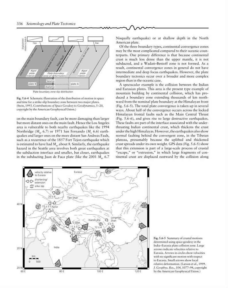
A spectacular example is the collision between the Indian
and Eurasian plates. This area is the present type example of
mountain building by continental collision, which has produced a boundary zone extending thousands of km northward from the nominal plate boundary at the Himalayan front
(Fig. 5.6-5). The total plate convergence is taken up in several
ways. About half of the convergence occurs across the locked
Himalayan frontal faults such as the Main Central Thrust
(Fig. 5.6-6), and gives rise to large destructive earthquakes.
These faults are part of the interface associated with the underthrusting Indian continental crust, which thickens the crust
under the high Himalayas. However, the earthquakes also show
normal faulting behind the convergent zone, in the Tibetan
plateau, presumably because the uplifted and thickened
crust spreads under its own weight. GPS data (Fig. 5.6-5) show
that this extension is part of a large-scale process of crustal
“escape,” or “extrusion,” in which large fragments of continental crust are displaced eastward by the collision along
Fig. 5.6-4 Schematic illustration of the distribution of motion in space
and time for a strike-slip boundary zone between two major plates.
(Stein, 1993. Contributions of Space Geodesy to Geodynamics, 5–20,
copyright by the American Geophysical Union.)
on the main boundary fault, can be more damaging than larger
but more distant ones on the main fault. Hence the Los Angeles
area is vulnerable to both nearby earthquakes like the 1994
Northridge (M w 6.7) or 1971 San Fernando (M s 6.6) earthquakes and larger ones on the more distant San Andreas Fault,
such as a recurrence of the 1857 Fort Tejon earthquake which
is estimated to have had M w about 8. Similarly, the earthquake
hazard in the Seattle area involves both great earthquakes at
the subduction interface and smaller, but closer, earthquakes
in the subducting Juan de Fuca plate (like the 2001 M w 6.7
L o n g -t e rm
(M
y r) s te a d y (? ) p la te m o ti o n
M a jo r e p is o d ic s e is m ic s li p a n d c re e p
M a jo r f a u lt
M in o r e p is o d ic s e is m ic s li p a n d c re e p
Plate boundary
zone of deformation
M in o r e p is o d ic s e is m ic s li p a n d c re e p
Rigid
plate
interior
Seismic
Aseismic
Time
Displacement
relative to plate A
Time
plate B
plate A
Rigid
plate
interior
Plate boundary zone slip distribution
Fig. 5.6-5 Summary of crustal motions
determined using space geodesy in the
India–Eurasia plate collision zone. Large
arrows indicate velocities relative to
Eurasia. Arrows in circles show velocities
with no significant motion with respect
to Eurasia. Small arrows show local
relative deformation. (Larson et al., 1999.
J. Geophys. Res., 104, 1077–94, copyright
by the American Geophysical Union.)
40 N
20 N
20 N
60 E
80 E
100 E
120 E
0
500
km
India
10
11
47
44
l
10
46
29
30
18 ± 2
11 ± 3
12 ± 4
0 ± 5
7
23
4
2
4
10
velocity relative
to Eurasia
shortening/
extension
srike slip
20 ± 6
15 ± 5 Pamir
Tien Shan
Eurasia
H
i
m
a
l
a
y
a
S Tibet
Xianshuihe
Longmen
Shan
Nisqually earthquake) or at shallow depth in the North
American plate.
Of the three boundary types, continental convergence zones
may be the most complicated compared to their oceanic counterparts. One primary difference is that because continental
crust is much less dense than the upper mantle, it is not
subducted, and a Wadati–Benioff zone is not formed. As a
result, continental convergence zones in general do not have
intermediate and deep focus earthquakes. However, the plate
boundary tectonics occur over a broader and more complex
region than in the oceanic case.
A spectacular example is the collision between the Indian
and Eurasian plates. This area is the present type example of
mountain building by continental collision, which has produced a boundary zone extending thousands of km northward from the nominal plate boundary at the Himalayan front
(Fig. 5.6-5). The total plate convergence is taken up in several
ways. About half of the convergence occurs across the locked
Himalayan frontal faults such as the Main Central Thrust
(Fig. 5.6-6), and gives rise to large destructive earthquakes.
These faults are part of the interface associated with the underthrusting Indian continental crust, which thickens the crust
under the high Himalayas. However, the earthquakes also show
normal faulting behind the convergent zone, in the Tibetan
plateau, presumably because the uplifted and thickened
crust spreads under its own weight. GPS data (Fig. 5.6-5) show
that this extension is part of a large-scale process of crustal
“escape,” or “extrusion,” in which large fragments of continental crust are displaced eastward by the collision along
Fig. 5.6-4 Schematic illustration of the distribution of motion in space
and time for a strike-slip boundary zone between two major plates.
(Stein, 1993. Contributions of Space Geodesy to Geodynamics, 5–20,
copyright by the American Geophysical Union.)
on the main boundary fault, can be more damaging than larger
but more distant ones on the main fault. Hence the Los Angeles
area is vulnerable to both nearby earthquakes like the 1994
Northridge (M w 6.7) or 1971 San Fernando (M s 6.6) earthquakes and larger ones on the more distant San Andreas Fault,
such as a recurrence of the 1857 Fort Tejon earthquake which
is estimated to have had M w about 8. Similarly, the earthquake
hazard in the Seattle area involves both great earthquakes at
the subduction interface and smaller, but closer, earthquakes
in the subducting Juan de Fuca plate (like the 2001 M w 6.7
L o n g -t e rm
(M
y r) s te a d y (? ) p la te m o ti o n
M a jo r e p is o d ic s e is m ic s li p a n d c re e p
M a jo r f a u lt
M in o r e p is o d ic s e is m ic s li p a n d c re e p
Plate boundary
zone of deformation
M in o r e p is o d ic s e is m ic s li p a n d c re e p
Rigid
plate
interior
Seismic
Aseismic
Time
Displacement
relative to plate A
Time
plate B
plate A
Rigid
plate
interior
Plate boundary zone slip distribution
Fig. 5.6-5 Summary of crustal motions
determined using space geodesy in the
India–Eurasia plate collision zone. Large
arrows indicate velocities relative to
Eurasia. Arrows in circles show velocities
with no significant motion with respect
to Eurasia. Small arrows show local
relative deformation. (Larson et al., 1999.
J. Geophys. Res., 104, 1077–94, copyright
by the American Geophysical Union.)
40 N
20 N
20 N
60 E
80 E
100 E
120 E
0
500
km
India
10
11
47
44
l
10
46
29
30
18 ± 2
11 ± 3
12 ± 4
0 ± 5
7
23
4
2
4
10
velocity relative
to Eurasia
shortening/
extension
srike slip
20 ± 6
15 ± 5 Pamir
Tien Shan
Eurasia
H
i
m
a
l
a
y
a
S Tibet
Xianshuihe
Longmen
Shan