

0
50
100
150
Indian
lithosphere
Asthenosphere
India n co nt in en ta l cr us t
Tethyan slab
500
300
100
0
Gangetic
foredeep
Lesser
Himalaya MCT
High
Himalaya
suture
Indus Tsangpo
Tibetan
plateau
76°
34 °
32 °
N
30 °
78 °
81 °
84 °
87 °
90 °
9 6 °
2 6 °
2 8 °
3 0 °
E
9 3 °
L h a sa
1 3
ITS
Himalayan arc
IT S
M C T
M B T
1 3
Depth (km)
MBT
?
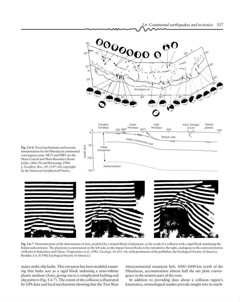
Fig. 5.6-6 Focal mechanisms and tectonic
interpretation for the Himalayan continental
convergence zone. MCT and MBT are the
Main Central and Main Boundary thrust
faults. (After Ni and Barazangi, 1984.
J. Geophys. Res., 89, 1147–64, copyright
by the American Geophysical Union.)
Fig. 5.6-7 Demonstration of the deformation of Asia, modeled by a striped block of plasticine, as the result of a collision with a rigid block simulating the
Indian subcontinent. The plasticine is constrained on the left side, so the impact forces blocks to be extruded to the right, analogous to the eastward motion
of blocks in Indochina and China. (Tapponnier et al., 1982. Geology, 10, 611–16, with permission of the publisher, the Geological Society of America,
Boulder, Co. © 1982 Geological Society of America.)
5.6 Continental earthquakes and tectonics 337
intracontinental mountain belt, 1000–2000 km north of the
Himalayas, accommodates almost half the net plate convergence in the western part of the zone.
In addition to providing data about a collision region’s
kinematics, seismological studies provide insight into its mechmajor strike-slip faults. This extrusion has been modeled assuming that India acts as a rigid block indenting a semi-infinite
plastic medium (Asia), giving rise to a complicated faulting and
slip pattern (Fig. 5.6-7). The extent of the collision is illustrated
by GPS data and focal mechanisms showing that the Tien Shan
50
100
150
Indian
lithosphere
Asthenosphere
India n co nt in en ta l cr us t
Tethyan slab
500
300
100
0
Gangetic
foredeep
Lesser
Himalaya MCT
High
Himalaya
suture
Indus Tsangpo
Tibetan
plateau
76°
34 °
32 °
N
30 °
78 °
81 °
84 °
87 °
90 °
9 6 °
2 6 °
2 8 °
3 0 °
E
9 3 °
L h a sa
1 3
ITS
Himalayan arc
IT S
M C T
M B T
1 3
Depth (km)
MBT
?
Fig. 5.6-6 Focal mechanisms and tectonic
interpretation for the Himalayan continental
convergence zone. MCT and MBT are the
Main Central and Main Boundary thrust
faults. (After Ni and Barazangi, 1984.
J. Geophys. Res., 89, 1147–64, copyright
by the American Geophysical Union.)
Fig. 5.6-7 Demonstration of the deformation of Asia, modeled by a striped block of plasticine, as the result of a collision with a rigid block simulating the
Indian subcontinent. The plasticine is constrained on the left side, so the impact forces blocks to be extruded to the right, analogous to the eastward motion
of blocks in Indochina and China. (Tapponnier et al., 1982. Geology, 10, 611–16, with permission of the publisher, the Geological Society of America,
Boulder, Co. © 1982 Geological Society of America.)
5.6 Continental earthquakes and tectonics 337
intracontinental mountain belt, 1000–2000 km north of the
Himalayas, accommodates almost half the net plate convergence in the western part of the zone.
In addition to providing data about a collision region’s
kinematics, seismological studies provide insight into its mechmajor strike-slip faults. This extrusion has been modeled assuming that India acts as a rigid block indenting a semi-infinite
plastic medium (Asia), giving rise to a complicated faulting and
slip pattern (Fig. 5.6-7). The extent of the collision is illustrated
by GPS data and focal mechanisms showing that the Tien Shan