

40°N
30°N
20°E
10°E
0°E
10°W
20°W
30°W
m b > 4
m b > 5.5
Gloria
fault
Terceira
rift
Gibraltar
El Asnam
Sicily
40°N
30°N
20°E
10°E
0°E
10°W
20°W
30°W
African plate
20 mm/yr
Gloria
fault
Terceira
rift
23 mm/yr
North
American
plate
Eurasian plate
4 mm/yr
El Asnam
Sicily
Gibraltar
4 mm/yr
4 mm/yr
4 mm/yr
4 mm/yr
5 mm/yr
6 mm/yr
6 mm/yr
7 mm/yr
America–South America boundary is only about 1 mm/yr a
much slower than the approximately 20 mm/yr along the MidAtlantic ridge. The North America–South America boundary
is thus considered a diffuse, slow-moving boundary zone,
although its location and motion are not well constrained.
Another reason for treating this as a boundary zone is that
paleomagnetic reconstructions find that over the past 70 Myr
the two plates have moved relative to each other as the Atlantic
Ocean opened.
In general, 1–2 mm/yr is an approximate lower limit for
plate boundary deformation. Regions with motions faster
than this are generally viewed as plate boundaries, and slower
deformation is generally treated as intraplate. However, there
is no generally accepted criterion, and evidence from seismicity
and topography is also considered. Put another way, in many
cases one can regard a region as either a slow-moving plate
boundary zone or a zone of intraplate deformation, and
“intraplate” earthquakes are often just ones not on an obvious
plate boundary.
The Atlantic example (Fig. 5.2-1) shows that in addition
to the North America–South America boundary zone, some
intraplate seismicity is concentrated in other areas associated
with tectonic features. For example, seismicity between Green1 Numerical models that infer the amount of upwelling mantle material from how
elevated the sea floor is relative to the normal depth–age curves estimate that Hawaii
has a buoyancy flux 5–10 times greater than that of Bermuda (Sleep, 1990).
land and North America is likely related to the former spreading ridge that opened this part of the Atlantic (the Labrador
Sea). Although this spreading stopped about 43 Myr ago, the
fossil ridge appears to remain a weak zone along which
intraplate stresses cause some motion. Intraplate seismicity is
often associated with such fossil structures. Concentrations of
seismicity are also associated with the Bermuda (32°N, 65°W),
Cape Verde (17°N, 25°W), and Canary (26°N, 17°W) hot
spots. Focal mechanism studies are consistent with the earthquakes reflecting heating of the lithosphere by the hot spots.
Hawaii, the most impressive hot spot trace in the oceans
(Fig. 5.2-7), 1 provides the best example of intraplate earthquakes associated with hot spot processes (Fig. 5.5-3). Small
earthquakes are associated with magma upwelling in the rift
zones. Larger earthquakes, which occur on a time scale of tens
of years, reflect sliding of the volcanic edifice on subhorizontal
faults that are thought to be a layer of weak sediments at the
top of the old oceanic crust on which the volcanic island
formed. These earthquakes can be quite large a the 1975
5.5 Oceanic intraplate earthquakes and tectonics 327
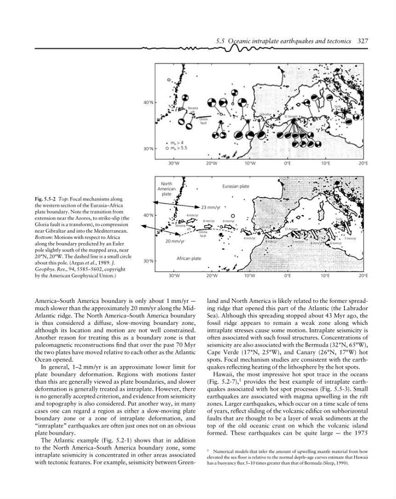
Fig. 5.5-2 Top: Focal mechanisms along
the western section of the Eurasia–Africa
plate boundary. Note the transition from
extension near the Azores, to strike-slip (the
Gloria fault is a transform), to compression
near Gibraltar and into the Mediterranean.
Bottom: Motions with respect to Africa
along the boundary predicted by an Euler
pole slightly south of the mapped area, near
20°N, 20°W. The dashed line is a small circle
about this pole. (Argus et al., 1989. J.
Geophys. Res., 94, 5585–5602, copyright
by the American Geophysical Union.)
30°N
20°E
10°E
0°E
10°W
20°W
30°W
m b > 4
m b > 5.5
Gloria
fault
Terceira
rift
Gibraltar
El Asnam
Sicily
40°N
30°N
20°E
10°E
0°E
10°W
20°W
30°W
African plate
20 mm/yr
Gloria
fault
Terceira
rift
23 mm/yr
North
American
plate
Eurasian plate
4 mm/yr
El Asnam
Sicily
Gibraltar
4 mm/yr
4 mm/yr
4 mm/yr
4 mm/yr
5 mm/yr
6 mm/yr
6 mm/yr
7 mm/yr
America–South America boundary is only about 1 mm/yr a
much slower than the approximately 20 mm/yr along the MidAtlantic ridge. The North America–South America boundary
is thus considered a diffuse, slow-moving boundary zone,
although its location and motion are not well constrained.
Another reason for treating this as a boundary zone is that
paleomagnetic reconstructions find that over the past 70 Myr
the two plates have moved relative to each other as the Atlantic
Ocean opened.
In general, 1–2 mm/yr is an approximate lower limit for
plate boundary deformation. Regions with motions faster
than this are generally viewed as plate boundaries, and slower
deformation is generally treated as intraplate. However, there
is no generally accepted criterion, and evidence from seismicity
and topography is also considered. Put another way, in many
cases one can regard a region as either a slow-moving plate
boundary zone or a zone of intraplate deformation, and
“intraplate” earthquakes are often just ones not on an obvious
plate boundary.
The Atlantic example (Fig. 5.2-1) shows that in addition
to the North America–South America boundary zone, some
intraplate seismicity is concentrated in other areas associated
with tectonic features. For example, seismicity between Green1 Numerical models that infer the amount of upwelling mantle material from how
elevated the sea floor is relative to the normal depth–age curves estimate that Hawaii
has a buoyancy flux 5–10 times greater than that of Bermuda (Sleep, 1990).
land and North America is likely related to the former spreading ridge that opened this part of the Atlantic (the Labrador
Sea). Although this spreading stopped about 43 Myr ago, the
fossil ridge appears to remain a weak zone along which
intraplate stresses cause some motion. Intraplate seismicity is
often associated with such fossil structures. Concentrations of
seismicity are also associated with the Bermuda (32°N, 65°W),
Cape Verde (17°N, 25°W), and Canary (26°N, 17°W) hot
spots. Focal mechanism studies are consistent with the earthquakes reflecting heating of the lithosphere by the hot spots.
Hawaii, the most impressive hot spot trace in the oceans
(Fig. 5.2-7), 1 provides the best example of intraplate earthquakes associated with hot spot processes (Fig. 5.5-3). Small
earthquakes are associated with magma upwelling in the rift
zones. Larger earthquakes, which occur on a time scale of tens
of years, reflect sliding of the volcanic edifice on subhorizontal
faults that are thought to be a layer of weak sediments at the
top of the old oceanic crust on which the volcanic island
formed. These earthquakes can be quite large a the 1975
5.5 Oceanic intraplate earthquakes and tectonics 327
Fig. 5.5-2 Top: Focal mechanisms along
the western section of the Eurasia–Africa
plate boundary. Note the transition from
extension near the Azores, to strike-slip (the
Gloria fault is a transform), to compression
near Gibraltar and into the Mediterranean.
Bottom: Motions with respect to Africa
along the boundary predicted by an Euler
pole slightly south of the mapped area, near
20°N, 20°W. The dashed line is a small circle
about this pole. (Argus et al., 1989. J.
Geophys. Res., 94, 5585–5602, copyright
by the American Geophysical Union.)