

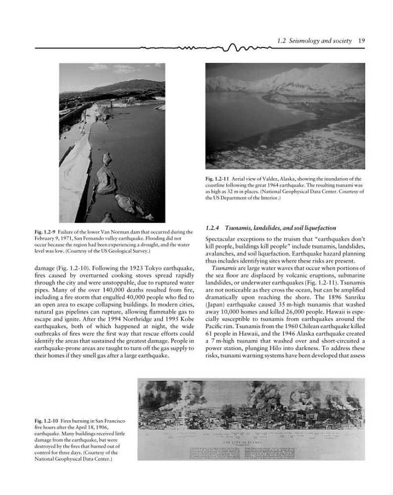
Fig. 1.2-9 Failure of the lower Van Norman dam that occurred during the
February 9, 1971, San Fernando valley earthquake. Flooding did not
occur because the region had been experiencing a drought, and the water
level was low. (Courtesy of the US Geological Survey.)
Fig. 1.2-11 Aerial view of Valdez, Alaska, showing the inundation of the
coastline following the great 1964 earthquake. The resulting tsunami was
as high as 32 m in places. (National Geophysical Data Center. Courtesy of
the US Department of the Interior.)
1.2.4 Tsunamis, landslides, and soil liquefaction
Spectacular exceptions to the truism that “earthquakes don’t
kill people, buildings kill people” include tsunamis, landslides,
avalanches, and soil liquefaction. Earthquake hazard planning
thus includes identifying sites where these risks are present.
Tsunamis are large water waves that occur when portions of
the sea floor are displaced by volcanic eruptions, submarine
landslides, or underwater earthquakes (Fig. 1.2-11). Tsunamis
are not noticeable as they cross the ocean, but can be amplified
dramatically upon reaching the shore. The 1896 Sanriku
(Japan) earthquake caused 35 m-high tsunamis that washed
away 10,000 homes and killed 26,000 people. Hawaii is especially susceptible to tsunamis from earthquakes around the
Pacific rim. Tsunamis from the 1960 Chilean earthquake killed
61 people in Hawaii, and the 1946 Alaska earthquake created
a 7 m-high tsunami that washed over and short-circuited a
power station, plunging Hilo into darkness. To address these
risks, tsunami warning systems have been developed that assess
Fig. 1.2-10 Fires burning in San Francisco
five hours after the April 18, 1906,
earthquake. Many buildings received little
damage from the earthquake, but were
destroyed by the fires that burned out of
control for three days. (Courtesy of the
National Geophysical Data Center.)
1.2 Seismology and society 19
damage (Fig. 1.2-10). Following the 1923 Tokyo earthquake,
fires caused by overturned cooking stoves spread rapidly
through the city and were unstoppable, due to ruptured water
pipes. Many of the over 140,000 deaths resulted from fire,
including a fire storm that engulfed 40,000 people who fled to
an open area to escape collapsing buildings. In modern cities,
natural gas pipelines can rupture, allowing flammable gas to
escape and ignite. After the 1994 Northridge and 1995 Kobe
earthquakes, both of which happened at night, the wide
outbreaks of fires were the first way that rescue efforts could
identify the areas that sustained the greatest damage. People in
earthquake-prone areas are taught to turn off the gas supply to
their homes if they smell gas after a large earthquake.
February 9, 1971, San Fernando valley earthquake. Flooding did not
occur because the region had been experiencing a drought, and the water
level was low. (Courtesy of the US Geological Survey.)
Fig. 1.2-11 Aerial view of Valdez, Alaska, showing the inundation of the
coastline following the great 1964 earthquake. The resulting tsunami was
as high as 32 m in places. (National Geophysical Data Center. Courtesy of
the US Department of the Interior.)
1.2.4 Tsunamis, landslides, and soil liquefaction
Spectacular exceptions to the truism that “earthquakes don’t
kill people, buildings kill people” include tsunamis, landslides,
avalanches, and soil liquefaction. Earthquake hazard planning
thus includes identifying sites where these risks are present.
Tsunamis are large water waves that occur when portions of
the sea floor are displaced by volcanic eruptions, submarine
landslides, or underwater earthquakes (Fig. 1.2-11). Tsunamis
are not noticeable as they cross the ocean, but can be amplified
dramatically upon reaching the shore. The 1896 Sanriku
(Japan) earthquake caused 35 m-high tsunamis that washed
away 10,000 homes and killed 26,000 people. Hawaii is especially susceptible to tsunamis from earthquakes around the
Pacific rim. Tsunamis from the 1960 Chilean earthquake killed
61 people in Hawaii, and the 1946 Alaska earthquake created
a 7 m-high tsunami that washed over and short-circuited a
power station, plunging Hilo into darkness. To address these
risks, tsunami warning systems have been developed that assess
Fig. 1.2-10 Fires burning in San Francisco
five hours after the April 18, 1906,
earthquake. Many buildings received little
damage from the earthquake, but were
destroyed by the fires that burned out of
control for three days. (Courtesy of the
National Geophysical Data Center.)
1.2 Seismology and society 19
damage (Fig. 1.2-10). Following the 1923 Tokyo earthquake,
fires caused by overturned cooking stoves spread rapidly
through the city and were unstoppable, due to ruptured water
pipes. Many of the over 140,000 deaths resulted from fire,
including a fire storm that engulfed 40,000 people who fled to
an open area to escape collapsing buildings. In modern cities,
natural gas pipelines can rupture, allowing flammable gas to
escape and ignite. After the 1994 Northridge and 1995 Kobe
earthquakes, both of which happened at night, the wide
outbreaks of fires were the first way that rescue efforts could
identify the areas that sustained the greatest damage. People in
earthquake-prone areas are taught to turn off the gas supply to
their homes if they smell gas after a large earthquake.