

322 Seismology and Plate Tectonics
80°
Oc ea nic lith os ph ere
Main shock
Continental lithosphere
Asthenosphere
Aseismic slip
Foreshock
100 km
70°W
0
km
200
x
1960(8.3)[9.5]
60
20
0
−20
−40
−60
0
30
60
90
120
150
180
−150
−120
−90
−60
−30
0
40
60
20
0
−20
−40
−60
40
0
30
60
90
120
150
180
−150
−120
−90
−60
−30
0
1928(8.0)
1906(8.4)
1922(8.3)[8.5]
1942(8.1)
1974(7.6)
1940(8.0)
1966(7.5)
1970(7.8)
1906(8.6)[8.8]
1975(7.9)
1941(8.3)
1946(8.1)
1969(8.0)
1964(8.4)[9.2]
1958(7.9)
1949(8.1)
1957(8
1
/4)[9.1]
1929(8.1)
1938(8.3)
1959(81/4)
1923(8.3)
1965(8.1)[8.7]
1906(8.0)
1952(81/4)[9.0]
1904(8.0,8.1)
1918(8
1
/4)
1905(8
1
/4,8
1
/4)
1957(8.3)
1931(8.0)
1920(8.5)
1927(8.0)
1911(8.4)
1958(8.7)
1969(7.8)
1952(8.3)
1968(7.9)
1933(8.5)
1963(8.1)[8.5]
1923(8.2)
1906(8
1
/4)
1932(8.1)
1907(8.1)
1944(8.0)
1946(8.2)
1906(8.1)
1939(8.0)
1934(8.2)
1917(8.3)
1919(8.3)
1917(8.0)
1920(8)
1971(8.1)
1938(8.2)[8.5]
1932(8.0)
1924(8.3)
1976(8.2)
1918(8
1
/4)
1948(8.2)
1941(8.1)
1920(8)
1951(8.0)
1939(8.0)
1907(8.0)
1905(8.0)
1945(8
1
/4)
1934(8.3)
1950(8.6)[8.6]
1912(8.0)
1904–76
M s ≥ 8.0
Plus Alaska, 1958 (7.9)
Peru, 1966 (7.5)
Tokachi-Oki, 1968 (7.9)
Kurile, 1969 (7.8)
Peru, 1970 (7.8)
Peru, 1974 (7.6)
Azores, 1975 (7.9)
1976(8.0)
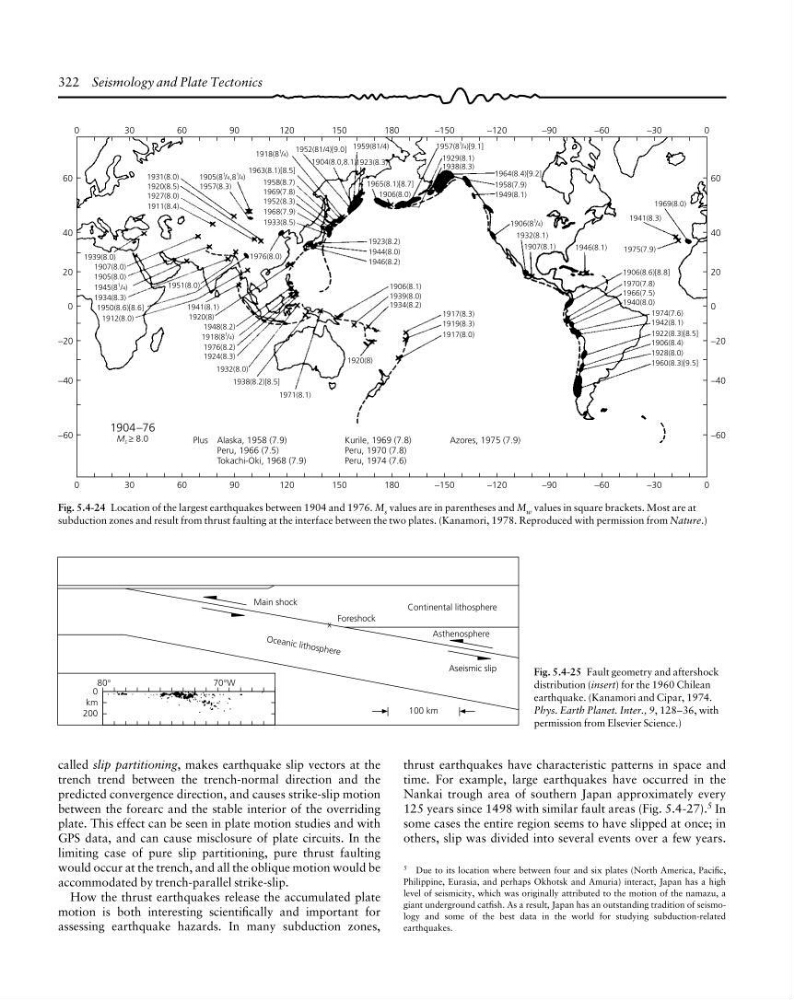
Fig. 5.4-24 Location of the largest earthquakes between 1904 and 1976. M s values are in parentheses and M w values in square brackets. Most are at
subduction zones and result from thrust faulting at the interface between the two plates. (Kanamori, 1978. Reproduced with permission from Nature.)
Fig. 5.4-25 Fault geometry and aftershock
distribution (insert) for the 1960 Chilean
earthquake. (Kanamori and Cipar, 1974.
Phys. Earth Planet. Inter., 9, 128–36, with
permission from Elsevier Science.)
5 Due to its location where between four and six plates (North America, Pacific,
Philippine, Eurasia, and perhaps Okhotsk and Amuria) interact, Japan has a high
level of seismicity, which was originally attributed to the motion of the namazu, a
giant underground catfish. As a result, Japan has an outstanding tradition of seismology and some of the best data in the world for studying subduction-related
earthquakes.
called slip partitioning, makes earthquake slip vectors at the
trench trend between the trench-normal direction and the
predicted convergence direction, and causes strike-slip motion
between the forearc and the stable interior of the overriding
plate. This effect can be seen in plate motion studies and with
GPS data, and can cause misclosure of plate circuits. In the
limiting case of pure slip partitioning, pure thrust faulting
would occur at the trench, and all the oblique motion would be
accommodated by trench-parallel strike-slip.
How the thrust earthquakes release the accumulated plate
motion is both interesting scientifically and important for
assessing earthquake hazards. In many subduction zones,
thrust earthquakes have characteristic patterns in space and
time. For example, large earthquakes have occurred in the
Nankai trough area of southern Japan approximately every
125 years since 1498 with similar fault areas (Fig. 5.4-27). 5 In
some cases the entire region seems to have slipped at once; in
others, slip was divided into several events over a few years.
80°
Oc ea nic lith os ph ere
Main shock
Continental lithosphere
Asthenosphere
Aseismic slip
Foreshock
100 km
70°W
0
km
200
x
1960(8.3)[9.5]
60
20
0
−20
−40
−60
0
30
60
90
120
150
180
−150
−120
−90
−60
−30
0
40
60
20
0
−20
−40
−60
40
0
30
60
90
120
150
180
−150
−120
−90
−60
−30
0
1928(8.0)
1906(8.4)
1922(8.3)[8.5]
1942(8.1)
1974(7.6)
1940(8.0)
1966(7.5)
1970(7.8)
1906(8.6)[8.8]
1975(7.9)
1941(8.3)
1946(8.1)
1969(8.0)
1964(8.4)[9.2]
1958(7.9)
1949(8.1)
1957(8
1
/4)[9.1]
1929(8.1)
1938(8.3)
1959(81/4)
1923(8.3)
1965(8.1)[8.7]
1906(8.0)
1952(81/4)[9.0]
1904(8.0,8.1)
1918(8
1
/4)
1905(8
1
/4,8
1
/4)
1957(8.3)
1931(8.0)
1920(8.5)
1927(8.0)
1911(8.4)
1958(8.7)
1969(7.8)
1952(8.3)
1968(7.9)
1933(8.5)
1963(8.1)[8.5]
1923(8.2)
1906(8
1
/4)
1932(8.1)
1907(8.1)
1944(8.0)
1946(8.2)
1906(8.1)
1939(8.0)
1934(8.2)
1917(8.3)
1919(8.3)
1917(8.0)
1920(8)
1971(8.1)
1938(8.2)[8.5]
1932(8.0)
1924(8.3)
1976(8.2)
1918(8
1
/4)
1948(8.2)
1941(8.1)
1920(8)
1951(8.0)
1939(8.0)
1907(8.0)
1905(8.0)
1945(8
1
/4)
1934(8.3)
1950(8.6)[8.6]
1912(8.0)
1904–76
M s ≥ 8.0
Plus Alaska, 1958 (7.9)
Peru, 1966 (7.5)
Tokachi-Oki, 1968 (7.9)
Kurile, 1969 (7.8)
Peru, 1970 (7.8)
Peru, 1974 (7.6)
Azores, 1975 (7.9)
1976(8.0)
Fig. 5.4-24 Location of the largest earthquakes between 1904 and 1976. M s values are in parentheses and M w values in square brackets. Most are at
subduction zones and result from thrust faulting at the interface between the two plates. (Kanamori, 1978. Reproduced with permission from Nature.)
Fig. 5.4-25 Fault geometry and aftershock
distribution (insert) for the 1960 Chilean
earthquake. (Kanamori and Cipar, 1974.
Phys. Earth Planet. Inter., 9, 128–36, with
permission from Elsevier Science.)
5 Due to its location where between four and six plates (North America, Pacific,
Philippine, Eurasia, and perhaps Okhotsk and Amuria) interact, Japan has a high
level of seismicity, which was originally attributed to the motion of the namazu, a
giant underground catfish. As a result, Japan has an outstanding tradition of seismology and some of the best data in the world for studying subduction-related
earthquakes.
called slip partitioning, makes earthquake slip vectors at the
trench trend between the trench-normal direction and the
predicted convergence direction, and causes strike-slip motion
between the forearc and the stable interior of the overriding
plate. This effect can be seen in plate motion studies and with
GPS data, and can cause misclosure of plate circuits. In the
limiting case of pure slip partitioning, pure thrust faulting
would occur at the trench, and all the oblique motion would be
accommodated by trench-parallel strike-slip.
How the thrust earthquakes release the accumulated plate
motion is both interesting scientifically and important for
assessing earthquake hazards. In many subduction zones,
thrust earthquakes have characteristic patterns in space and
time. For example, large earthquakes have occurred in the
Nankai trough area of southern Japan approximately every
125 years since 1498 with similar fault areas (Fig. 5.4-27). 5 In
some cases the entire region seems to have slipped at once; in
others, slip was divided into several events over a few years.