

296 Seismology and Plate Tectonics
tive plate motions. One of the most important results of space
geodesy for seismology is that plate motions have remained
generally steady over the past few million years. This is shown
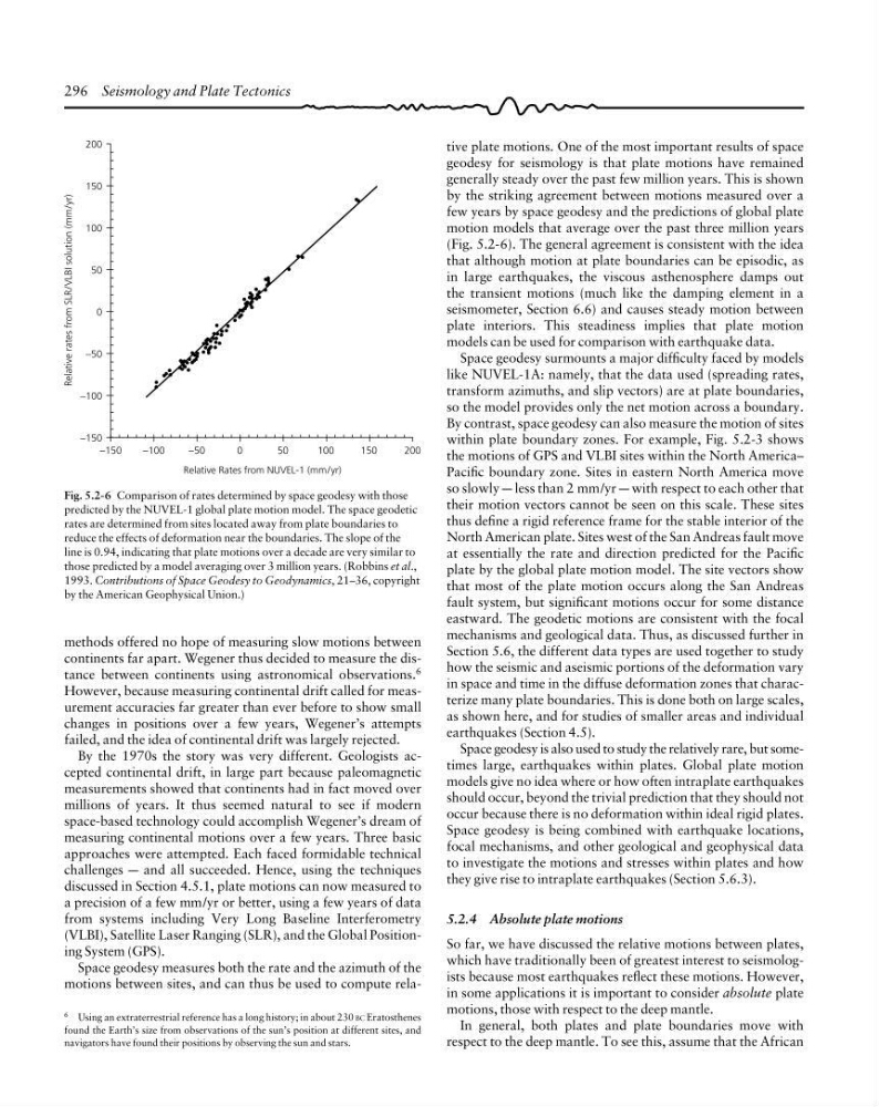
by the striking agreement between motions measured over a
few years by space geodesy and the predictions of global plate
motion models that average over the past three million years
(Fig. 5.2-6). The general agreement is consistent with the idea
that although motion at plate boundaries can be episodic, as
in large earthquakes, the viscous asthenosphere damps out
the transient motions (much like the damping element in a
seismometer, Section 6.6) and causes steady motion between
plate interiors. This steadiness implies that plate motion
models can be used for comparison with earthquake data.
Space geodesy surmounts a major difficulty faced by models
like NUVEL-1A: namely, that the data used (spreading rates,
transform azimuths, and slip vectors) are at plate boundaries,
so the model provides only the net motion across a boundary.
By contrast, space geodesy can also measure the motion of sites
within plate boundary zones. For example, Fig. 5.2-3 shows
the motions of GPS and VLBI sites within the North America–
Pacific boundary zone. Sites in eastern North America move
so slowly a less than 2 mm/yr a with respect to each other that
their motion vectors cannot be seen on this scale. These sites
thus define a rigid reference frame for the stable interior of the
North American plate. Sites west of the San Andreas fault move
at essentially the rate and direction predicted for the Pacific
plate by the global plate motion model. The site vectors show
that most of the plate motion occurs along the San Andreas
fault system, but significant motions occur for some distance
eastward. The geodetic motions are consistent with the focal
mechanisms and geological data. Thus, as discussed further in
Section 5.6, the different data types are used together to study
how the seismic and aseismic portions of the deformation vary
in space and time in the diffuse deformation zones that characterize many plate boundaries. This is done both on large scales,
as shown here, and for studies of smaller areas and individual
earthquakes (Section 4.5).
Space geodesy is also used to study the relatively rare, but sometimes large, earthquakes within plates. Global plate motion
models give no idea where or how often intraplate earthquakes
should occur, beyond the trivial prediction that they should not
occur because there is no deformation within ideal rigid plates.
Space geodesy is being combined with earthquake locations,
focal mechanisms, and other geological and geophysical data
to investigate the motions and stresses within plates and how
they give rise to intraplate earthquakes (Section 5.6.3).
5.2.4 Absolute plate motions
So far, we have discussed the relative motions between plates,
which have traditionally been of greatest interest to seismologists because most earthquakes reflect these motions. However,
in some applications it is important to consider absolute plate
motions, those with respect to the deep mantle.
In general, both plates and plate boundaries move with
respect to the deep mantle. To see this, assume that the African
Fig. 5.2-6 Comparison of rates determined by space geodesy with those
predicted by the NUVEL-1 global plate motion model. The space geodetic
rates are determined from sites located away from plate boundaries to
reduce the effects of deformation near the boundaries. The slope of the
line is 0.94, indicating that plate motions over a decade are very similar to
those predicted by a model averaging over 3 million years. (Robbins et al.,
1993. Contributions of Space Geodesy to Geodynamics, 21–36, copyright
by the American Geophysical Union.)
Relative rates from SLR/VLBI solution (mm/yr)
200
150
100
50
0
−50
−100
−150
200
−150
−100
−50
0
50
100
150
Relative Rates from NUVEL-1 (mm/yr)
methods offered no hope of measuring slow motions between
continents far apart. Wegener thus decided to measure the distance between continents using astronomical observations. 6
However, because measuring continental drift called for measurement accuracies far greater than ever before to show small
changes in positions over a few years, Wegener’s attempts
failed, and the idea of continental drift was largely rejected.
By the 1970s the story was very different. Geologists accepted continental drift, in large part because paleomagnetic
measurements showed that continents had in fact moved over
millions of years. It thus seemed natural to see if modern
space-based technology could accomplish Wegener’s dream of
measuring continental motions over a few years. Three basic
approaches were attempted. Each faced formidable technical
challenges a and all succeeded. Hence, using the techniques
discussed in Section 4.5.1, plate motions can now measured to
a precision of a few mm/yr or better, using a few years of data
from systems including Very Long Baseline Interferometry
(VLBI), Satellite Laser Ranging (SLR), and the Global Positioning System (GPS).
Space geodesy measures both the rate and the azimuth of the
motions between sites, and can thus be used to compute rela6 Using an extraterrestrial reference has a long history; in about 230 BC Eratosthenes
found the Earth’s size from observations of the sun’s position at different sites, and
navigators have found their positions by observing the sun and stars.
tive plate motions. One of the most important results of space
geodesy for seismology is that plate motions have remained
generally steady over the past few million years. This is shown
by the striking agreement between motions measured over a
few years by space geodesy and the predictions of global plate
motion models that average over the past three million years
(Fig. 5.2-6). The general agreement is consistent with the idea
that although motion at plate boundaries can be episodic, as
in large earthquakes, the viscous asthenosphere damps out
the transient motions (much like the damping element in a
seismometer, Section 6.6) and causes steady motion between
plate interiors. This steadiness implies that plate motion
models can be used for comparison with earthquake data.
Space geodesy surmounts a major difficulty faced by models
like NUVEL-1A: namely, that the data used (spreading rates,
transform azimuths, and slip vectors) are at plate boundaries,
so the model provides only the net motion across a boundary.
By contrast, space geodesy can also measure the motion of sites
within plate boundary zones. For example, Fig. 5.2-3 shows
the motions of GPS and VLBI sites within the North America–
Pacific boundary zone. Sites in eastern North America move
so slowly a less than 2 mm/yr a with respect to each other that
their motion vectors cannot be seen on this scale. These sites
thus define a rigid reference frame for the stable interior of the
North American plate. Sites west of the San Andreas fault move
at essentially the rate and direction predicted for the Pacific
plate by the global plate motion model. The site vectors show
that most of the plate motion occurs along the San Andreas
fault system, but significant motions occur for some distance
eastward. The geodetic motions are consistent with the focal
mechanisms and geological data. Thus, as discussed further in
Section 5.6, the different data types are used together to study
how the seismic and aseismic portions of the deformation vary
in space and time in the diffuse deformation zones that characterize many plate boundaries. This is done both on large scales,
as shown here, and for studies of smaller areas and individual
earthquakes (Section 4.5).
Space geodesy is also used to study the relatively rare, but sometimes large, earthquakes within plates. Global plate motion
models give no idea where or how often intraplate earthquakes
should occur, beyond the trivial prediction that they should not
occur because there is no deformation within ideal rigid plates.
Space geodesy is being combined with earthquake locations,
focal mechanisms, and other geological and geophysical data
to investigate the motions and stresses within plates and how
they give rise to intraplate earthquakes (Section 5.6.3).
5.2.4 Absolute plate motions
So far, we have discussed the relative motions between plates,
which have traditionally been of greatest interest to seismologists because most earthquakes reflect these motions. However,
in some applications it is important to consider absolute plate
motions, those with respect to the deep mantle.
In general, both plates and plate boundaries move with
respect to the deep mantle. To see this, assume that the African
Fig. 5.2-6 Comparison of rates determined by space geodesy with those
predicted by the NUVEL-1 global plate motion model. The space geodetic
rates are determined from sites located away from plate boundaries to
reduce the effects of deformation near the boundaries. The slope of the
line is 0.94, indicating that plate motions over a decade are very similar to
those predicted by a model averaging over 3 million years. (Robbins et al.,
1993. Contributions of Space Geodesy to Geodynamics, 21–36, copyright
by the American Geophysical Union.)
Relative rates from SLR/VLBI solution (mm/yr)
200
150
100
50
0
−50
−100
−150
200
−150
−100
−50
0
50
100
150
Relative Rates from NUVEL-1 (mm/yr)
methods offered no hope of measuring slow motions between
continents far apart. Wegener thus decided to measure the distance between continents using astronomical observations. 6
However, because measuring continental drift called for measurement accuracies far greater than ever before to show small
changes in positions over a few years, Wegener’s attempts
failed, and the idea of continental drift was largely rejected.
By the 1970s the story was very different. Geologists accepted continental drift, in large part because paleomagnetic
measurements showed that continents had in fact moved over
millions of years. It thus seemed natural to see if modern
space-based technology could accomplish Wegener’s dream of
measuring continental motions over a few years. Three basic
approaches were attempted. Each faced formidable technical
challenges a and all succeeded. Hence, using the techniques
discussed in Section 4.5.1, plate motions can now measured to
a precision of a few mm/yr or better, using a few years of data
from systems including Very Long Baseline Interferometry
(VLBI), Satellite Laser Ranging (SLR), and the Global Positioning System (GPS).
Space geodesy measures both the rate and the azimuth of the
motions between sites, and can thus be used to compute rela6 Using an extraterrestrial reference has a long history; in about 230 BC Eratosthenes
found the Earth’s size from observations of the sun’s position at different sites, and
navigators have found their positions by observing the sun and stars.