

4.5 Earthquake geodesy 261
the subduction interface and future large earthquakes on it.
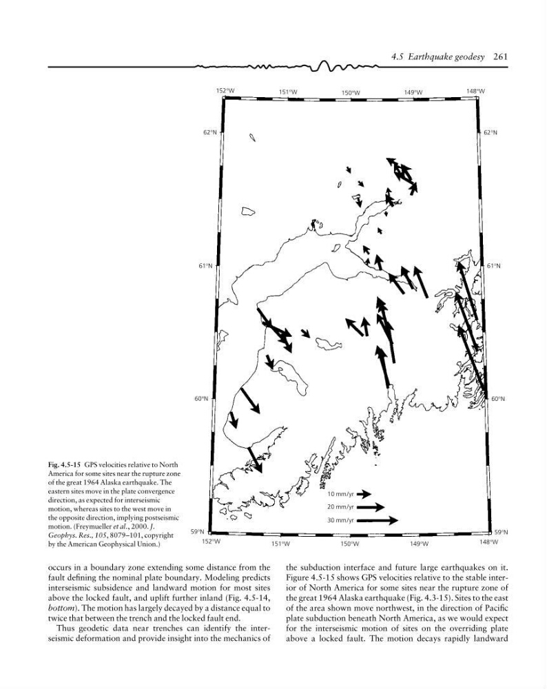
Figure 4.5-15 shows GPS velocities relative to the stable interior of North America for some sites near the rupture zone of
the great 1964 Alaska earthquake (Fig. 4.3-15). Sites to the east
of the area shown move northwest, in the direction of Pacific
plate subduction beneath North America, as we would expect
for the interseismic motion of sites on the overriding plate
above a locked fault. The motion decays rapidly landward
occurs in a boundary zone extending some distance from the
fault defining the nominal plate boundary. Modeling predicts
interseismic subsidence and landward motion for most sites
above the locked fault, and uplift further inland (Fig. 4.5-14,
bottom). The motion has largely decayed by a distance equal to
twice that between the trench and the locked fault end.
Thus geodetic data near trenches can identify the interseismic deformation and provide insight into the mechanics of
59°N
59°N
30 mm/yr
152°W
148°W
149°W
150°W
151°W
60°N
61°N
62°N
152°W
151°W
150°W
149°W
148°W
62°N
61°N
60°N
20 mm/yr
10 mm/yr
Fig. 4.5-15 GPS velocities relative to North
America for some sites near the rupture zone
of the great 1964 Alaska earthquake. The
eastern sites move in the plate convergence
direction, as expected for interseismic
motion, whereas sites to the west move in
the opposite direction, implying postseismic
motion. (Freymueller et al., 2000. J.
Geophys. Res., 105, 8079–101, copyright
by the American Geophysical Union.)
the subduction interface and future large earthquakes on it.
Figure 4.5-15 shows GPS velocities relative to the stable interior of North America for some sites near the rupture zone of
the great 1964 Alaska earthquake (Fig. 4.3-15). Sites to the east
of the area shown move northwest, in the direction of Pacific
plate subduction beneath North America, as we would expect
for the interseismic motion of sites on the overriding plate
above a locked fault. The motion decays rapidly landward
occurs in a boundary zone extending some distance from the
fault defining the nominal plate boundary. Modeling predicts
interseismic subsidence and landward motion for most sites
above the locked fault, and uplift further inland (Fig. 4.5-14,
bottom). The motion has largely decayed by a distance equal to
twice that between the trench and the locked fault end.
Thus geodetic data near trenches can identify the interseismic deformation and provide insight into the mechanics of
59°N
59°N
30 mm/yr
152°W
148°W
149°W
150°W
151°W
60°N
61°N
62°N
152°W
151°W
150°W
149°W
148°W
62°N
61°N
60°N
20 mm/yr
10 mm/yr
Fig. 4.5-15 GPS velocities relative to North
America for some sites near the rupture zone
of the great 1964 Alaska earthquake. The
eastern sites move in the plate convergence
direction, as expected for interseismic
motion, whereas sites to the west move in
the opposite direction, implying postseismic
motion. (Freymueller et al., 2000. J.
Geophys. Res., 105, 8079–101, copyright
by the American Geophysical Union.)