

252 Earthquakes
Baseline vector to be measured
Relative positioning
Constellation of GPS satellites
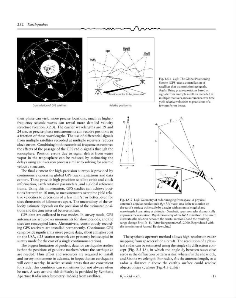
Fig. 4.5-1 Left: The Global Positioning
System (GPS) uses a constellation of
satellites that transmit timing signals.
Right: Using precise positions based on
signals from multiple satellites recorded at
multiple receivers, measurements over time
yield relative velocities to precisions of a
few mm /yr or better.
The synthetic aperture method allows high-resolution radar
mapping from spacecraft or aircraft. The resolution of a physical radar can be estimated using the single slit diffraction concept (Fig. 2.5-18), in which the angle θ d between successive
zeros in the diffraction pattern is λ/d, where d is the slit width,
and λ is the wavelength. For radar, d is the antenna length, so a
radar a distance r above the earth’s surface could resolve
objects of size x, where (Fig. 4.5-2, left)
θ d = λ /d = x/r.
(1)
x
d
θ
r
A 1
θ
H
h
A 2
r 2
r 1
B
r ˆ
D · r ˆ
D
Fig. 4.5-2 Left: Geometry of radar imaging from space. A physical
antenna’s angular resolution is θ d = λ /d = x/r, so x is the resolution on
the earth’s surface achievable by a radar with antenna length d and
wavelength λ operating at altitude r. Synthetic aperture radar dramatically
improves the resolution. Right: Geometry of the InSAR method. The insert
illustrates the relation between the crustal motion D and the resulting
range change δ r = (D · 5). (After Bürgmann et al., 2000. Reproduced with
the permission of Annual Reviews, Inc.)
their phase can yield more precise locations, much as higherfrequency seismic waves can reveal more detailed velocity
structure (Section 3.2.3). The carrier wavelengths are 19 and
24 cm, so precise phase measurements can resolve positions to
a fraction of these wavelengths. The use of differential signals
from multiple satellites recorded at multiple receivers reduces
clock errors. Combining both transmitted frequencies removes
the effects of the passage of the GPS radio signals through the
ionosphere. Position errors due to signal delays from water
vapor in the troposphere can be reduced by estimating the
delays using an inversion process similar to solving for seismic
velocity structure.
The final element for high-precision surveys is provided by
continuously operating global GPS tracking stations and data
centers. These provide high-precision satellite orbit and clock
information, earth rotation parameters, and a global reference
frame. Using this information, GPS studies can achieve positions better than 10 mm, so measurements over time yield relative velocities to precisions of a few mm/yr or better, even for
sites thousands of kilometers apart. The uncertainty of the velocity estimate depends on the precision of the estimated positions and the time interval between them.
GPS data are collected in two modes. In survey mode, GPS
antennas are set up over monuments for short periods, and the
sites are reoccupied later. Alternatively, continuously recording GPS receivers are installed permanently. Continuous GPS
can provide significantly more precise data, albeit at higher cost
(in the USA, a 25-station network can presently be occupied in
survey mode for the cost of a single continuous station).
The biggest limitation of geodetic data for earthquake studies
is that the positions of geodetic markers before the earthquake
are needed. Thus effort and resources are required to install
and survey monuments in advance, in hopes that an earthquake
will occur nearby. In active seismic areas that are convenient
for study, this condition can sometimes but not always often
be met. A way around this difficulty is provided by Synthetic
Aperture Radar interferometry (InSAR) from satellites.
Baseline vector to be measured
Relative positioning
Constellation of GPS satellites
Fig. 4.5-1 Left: The Global Positioning
System (GPS) uses a constellation of
satellites that transmit timing signals.
Right: Using precise positions based on
signals from multiple satellites recorded at
multiple receivers, measurements over time
yield relative velocities to precisions of a
few mm /yr or better.
The synthetic aperture method allows high-resolution radar
mapping from spacecraft or aircraft. The resolution of a physical radar can be estimated using the single slit diffraction concept (Fig. 2.5-18), in which the angle θ d between successive
zeros in the diffraction pattern is λ/d, where d is the slit width,
and λ is the wavelength. For radar, d is the antenna length, so a
radar a distance r above the earth’s surface could resolve
objects of size x, where (Fig. 4.5-2, left)
θ d = λ /d = x/r.
(1)
x
d
θ
r
A 1
θ
H
h
A 2
r 2
r 1
B
r ˆ
D · r ˆ
D
Fig. 4.5-2 Left: Geometry of radar imaging from space. A physical
antenna’s angular resolution is θ d = λ /d = x/r, so x is the resolution on
the earth’s surface achievable by a radar with antenna length d and
wavelength λ operating at altitude r. Synthetic aperture radar dramatically
improves the resolution. Right: Geometry of the InSAR method. The insert
illustrates the relation between the crustal motion D and the resulting
range change δ r = (D · 5). (After Bürgmann et al., 2000. Reproduced with
the permission of Annual Reviews, Inc.)
their phase can yield more precise locations, much as higherfrequency seismic waves can reveal more detailed velocity
structure (Section 3.2.3). The carrier wavelengths are 19 and
24 cm, so precise phase measurements can resolve positions to
a fraction of these wavelengths. The use of differential signals
from multiple satellites recorded at multiple receivers reduces
clock errors. Combining both transmitted frequencies removes
the effects of the passage of the GPS radio signals through the
ionosphere. Position errors due to signal delays from water
vapor in the troposphere can be reduced by estimating the
delays using an inversion process similar to solving for seismic
velocity structure.
The final element for high-precision surveys is provided by
continuously operating global GPS tracking stations and data
centers. These provide high-precision satellite orbit and clock
information, earth rotation parameters, and a global reference
frame. Using this information, GPS studies can achieve positions better than 10 mm, so measurements over time yield relative velocities to precisions of a few mm/yr or better, even for
sites thousands of kilometers apart. The uncertainty of the velocity estimate depends on the precision of the estimated positions and the time interval between them.
GPS data are collected in two modes. In survey mode, GPS
antennas are set up over monuments for short periods, and the
sites are reoccupied later. Alternatively, continuously recording GPS receivers are installed permanently. Continuous GPS
can provide significantly more precise data, albeit at higher cost
(in the USA, a 25-station network can presently be occupied in
survey mode for the cost of a single continuous station).
The biggest limitation of geodetic data for earthquake studies
is that the positions of geodetic markers before the earthquake
are needed. Thus effort and resources are required to install
and survey monuments in advance, in hopes that an earthquake
will occur nearby. In active seismic areas that are convenient
for study, this condition can sometimes but not always often
be met. A way around this difficulty is provided by Synthetic
Aperture Radar interferometry (InSAR) from satellites.