

Until recently, these measurements were typically made by
triangulation, which measures the angles between monuments
using a theodelite, or trilateration, which measures distances
with a laser. Vertical motion was measured by leveling, using a
precise level to sight on a distant measuring rod. However, the
advent of geodetic methods using signals from space permits all
three components of position to be measured to sub-centimeter
precision. As a result, geodetic data before and after earthquakes now give coseismic motion to high precision much
more easily than was previously possible.
Although the space-based technologies are among the most
complex used in the earth sciences, in essence they use electromagnetic waves in ways analogous to those we have discussed
for seismic waves. Three of these techniques are used to locate
geodetic markers. Very Long Baseline Interferometry (VLBI)
uses the difference in the time when radio signals from distant
quasars arrive at different points on earth. Satellite Laser
Ranging (SLR) uses the time required by light from groundbased lasers to bounce off satellites. The third approach relies
on the travel time of radio signals between satellites and ground
stations.
Although the various systems provide similar data, the third
approach via the Global Positioning System (GPS) 2 is presently
the system of choice for most tectonic applications. GPS was
developed in the late 1970s by the US Department of Defense
for real-time positioning and navigation. A constellation of
satellites transmit coded timing signals on a pair of microwave carrier frequencies synchronized to very precise on-board
atomic clocks. The timing signals are modulations of the carrier frequencies, analogous to those we discussed in the context
of phase and group velocities (Section 2.8.1). By determining
the ranges to a minimum of four satellites from the signal
delays and the broadcast satellite orbit information, a single
GPS receiver can determine its three-dimensional position
to a precision of 5 to 100 meters, depending on the level of
signal degradation imposed by the military (Fig. 4.5-1). 3 This
operation is conceptually the same as locating an earthquake
from arrivals at multiple seismometers, which we discuss in
Section 7.2. GPS positions are two to three times more precise
in the horizontal than in the vertical direction, because radio
signals arrive only from above, just as earthquake locations are
less precise in depth because waves arrive only from below.
The improvement to cm level or better precision is obtained
by using the phase delays of the microwave carriers. Because
the carriers have higher frequencies than the modulations,
4.5 Earthquake geodesy 251
1 The most familiar monuments are the metal disks attached to rocks often seen at
mountain peaks, but various other designs are also used in hope of minimizing the effects of soil or near-surface motion that mask the tectonic movement. In soft sediment, monuments are often steel rods driven deep into the earth. The popular term for
monuments is “benchmarks,” although geodesists traditionally reserve this term for
monuments used to study vertical motions.
2 Acronyms abound in space geodesy, given its space and military origins. Alternative meanings have been offered: the large VLBI project teams suggest “Very Large
Bunch of Investigators,” and the languid pace of GPS surveys prompted “Great Places
to Sleep.” There are also second-level acronyms involving other acronyms, such as
IGS for International GPS Service.
3 The Department of Defense can degrade GPS positioning via selective availability,
which introduces errors in the satellite clocks. This capability, which was discontinued in May 2000, reduced the precision of single receiver positions but had little effect
on precise geodetic positions.
′
′
′
⎛
⎝
⎜
⎜ ⎜
⎞
⎠
⎟
⎟ ⎟
=
′
− ′
⎛
⎝
⎜
⎜ ⎜
⎞
⎠
⎟
⎟ ⎟
+
′
− ′
⎛
⎝
⎜
⎜
⎞
⎠
⎟
⎟
λ
λ
λ
λ
λ
λ
λ
1
2
3
1
1
2
2
0 0
0
0
0 0
0 0
0 0 0
0 0
0 0
0
0
0
0 0
.
(49)
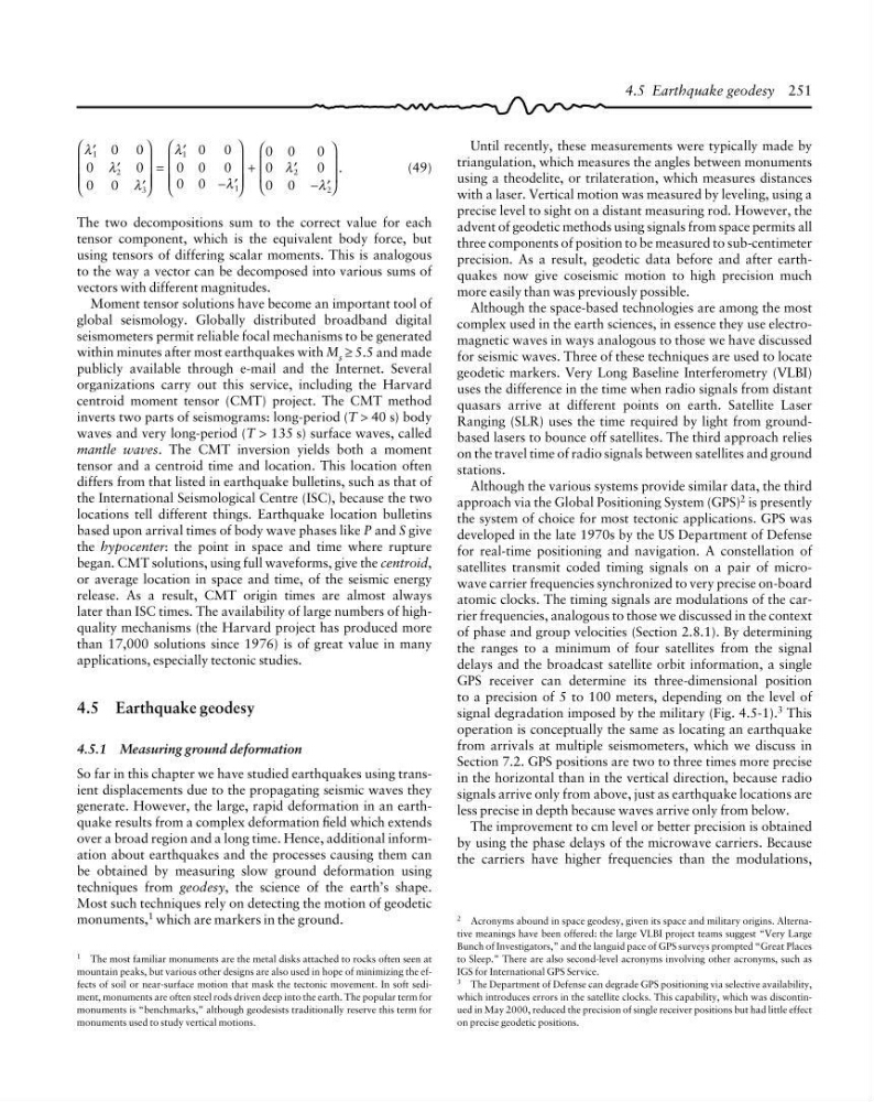
The two decompositions sum to the correct value for each
tensor component, which is the equivalent body force, but
using tensors of differing scalar moments. This is analogous
to the way a vector can be decomposed into various sums of
vectors with different magnitudes.
Moment tensor solutions have become an important tool of
global seismology. Globally distributed broadband digital
seismometers permit reliable focal mechanisms to be generated
within minutes after most earthquakes with M s ≥ 5.5 and made
publicly available through e-mail and the Internet. Several
organizations carry out this service, including the Harvard
centroid moment tensor (CMT) project. The CMT method
inverts two parts of seismograms: long-period (T > 40 s) body
waves and very long-period (T > 135 s) surface waves, called
mantle waves. The CMT inversion yields both a moment
tensor and a centroid time and location. This location often
differs from that listed in earthquake bulletins, such as that of
the International Seismological Centre (ISC), because the two
locations tell different things. Earthquake location bulletins
based upon arrival times of body wave phases like P and S give
the hypocenter: the point in space and time where rupture
began. CMT solutions, using full waveforms, give the centroid,
or average location in space and time, of the seismic energy
release. As a result, CMT origin times are almost always
later than ISC times. The availability of large numbers of highquality mechanisms (the Harvard project has produced more
than 17,000 solutions since 1976) is of great value in many
applications, especially tectonic studies.
4.5 Earthquake geodesy
4.5.1 Measuring ground deformation
So far in this chapter we have studied earthquakes using transient displacements due to the propagating seismic waves they
generate. However, the large, rapid deformation in an earthquake results from a complex deformation field which extends
over a broad region and a long time. Hence, additional information about earthquakes and the processes causing them can
be obtained by measuring slow ground deformation using
techniques from geodesy, the science of the earth’s shape.
Most such techniques rely on detecting the motion of geodetic
monuments, 1 which are markers in the ground.
triangulation, which measures the angles between monuments
using a theodelite, or trilateration, which measures distances
with a laser. Vertical motion was measured by leveling, using a
precise level to sight on a distant measuring rod. However, the
advent of geodetic methods using signals from space permits all
three components of position to be measured to sub-centimeter
precision. As a result, geodetic data before and after earthquakes now give coseismic motion to high precision much
more easily than was previously possible.
Although the space-based technologies are among the most
complex used in the earth sciences, in essence they use electromagnetic waves in ways analogous to those we have discussed
for seismic waves. Three of these techniques are used to locate
geodetic markers. Very Long Baseline Interferometry (VLBI)
uses the difference in the time when radio signals from distant
quasars arrive at different points on earth. Satellite Laser
Ranging (SLR) uses the time required by light from groundbased lasers to bounce off satellites. The third approach relies
on the travel time of radio signals between satellites and ground
stations.
Although the various systems provide similar data, the third
approach via the Global Positioning System (GPS) 2 is presently
the system of choice for most tectonic applications. GPS was
developed in the late 1970s by the US Department of Defense
for real-time positioning and navigation. A constellation of
satellites transmit coded timing signals on a pair of microwave carrier frequencies synchronized to very precise on-board
atomic clocks. The timing signals are modulations of the carrier frequencies, analogous to those we discussed in the context
of phase and group velocities (Section 2.8.1). By determining
the ranges to a minimum of four satellites from the signal
delays and the broadcast satellite orbit information, a single
GPS receiver can determine its three-dimensional position
to a precision of 5 to 100 meters, depending on the level of
signal degradation imposed by the military (Fig. 4.5-1). 3 This
operation is conceptually the same as locating an earthquake
from arrivals at multiple seismometers, which we discuss in
Section 7.2. GPS positions are two to three times more precise
in the horizontal than in the vertical direction, because radio
signals arrive only from above, just as earthquake locations are
less precise in depth because waves arrive only from below.
The improvement to cm level or better precision is obtained
by using the phase delays of the microwave carriers. Because
the carriers have higher frequencies than the modulations,
4.5 Earthquake geodesy 251
1 The most familiar monuments are the metal disks attached to rocks often seen at
mountain peaks, but various other designs are also used in hope of minimizing the effects of soil or near-surface motion that mask the tectonic movement. In soft sediment, monuments are often steel rods driven deep into the earth. The popular term for
monuments is “benchmarks,” although geodesists traditionally reserve this term for
monuments used to study vertical motions.
2 Acronyms abound in space geodesy, given its space and military origins. Alternative meanings have been offered: the large VLBI project teams suggest “Very Large
Bunch of Investigators,” and the languid pace of GPS surveys prompted “Great Places
to Sleep.” There are also second-level acronyms involving other acronyms, such as
IGS for International GPS Service.
3 The Department of Defense can degrade GPS positioning via selective availability,
which introduces errors in the satellite clocks. This capability, which was discontinued in May 2000, reduced the precision of single receiver positions but had little effect
on precise geodetic positions.
′
′
′
⎛
⎝
⎜
⎜ ⎜
⎞
⎠
⎟
⎟ ⎟
=
′
− ′
⎛
⎝
⎜
⎜ ⎜
⎞
⎠
⎟
⎟ ⎟
+
′
− ′
⎛
⎝
⎜
⎜
⎞
⎠
⎟
⎟
λ
λ
λ
λ
λ
λ
λ
1
2
3
1
1
2
2
0 0
0
0
0 0
0 0
0 0 0
0 0
0 0
0
0
0
0 0
.
(49)
The two decompositions sum to the correct value for each
tensor component, which is the equivalent body force, but
using tensors of differing scalar moments. This is analogous
to the way a vector can be decomposed into various sums of
vectors with different magnitudes.
Moment tensor solutions have become an important tool of
global seismology. Globally distributed broadband digital
seismometers permit reliable focal mechanisms to be generated
within minutes after most earthquakes with M s ≥ 5.5 and made
publicly available through e-mail and the Internet. Several
organizations carry out this service, including the Harvard
centroid moment tensor (CMT) project. The CMT method
inverts two parts of seismograms: long-period (T > 40 s) body
waves and very long-period (T > 135 s) surface waves, called
mantle waves. The CMT inversion yields both a moment
tensor and a centroid time and location. This location often
differs from that listed in earthquake bulletins, such as that of
the International Seismological Centre (ISC), because the two
locations tell different things. Earthquake location bulletins
based upon arrival times of body wave phases like P and S give
the hypocenter: the point in space and time where rupture
began. CMT solutions, using full waveforms, give the centroid,
or average location in space and time, of the seismic energy
release. As a result, CMT origin times are almost always
later than ISC times. The availability of large numbers of highquality mechanisms (the Harvard project has produced more
than 17,000 solutions since 1976) is of great value in many
applications, especially tectonic studies.
4.5 Earthquake geodesy
4.5.1 Measuring ground deformation
So far in this chapter we have studied earthquakes using transient displacements due to the propagating seismic waves they
generate. However, the large, rapid deformation in an earthquake results from a complex deformation field which extends
over a broad region and a long time. Hence, additional information about earthquakes and the processes causing them can
be obtained by measuring slow ground deformation using
techniques from geodesy, the science of the earth’s shape.
Most such techniques rely on detecting the motion of geodetic
monuments, 1 which are markers in the ground.