

Ground truthing is an important component in determining the cutoff value to
separate water from non-water areas on the images. It is also needed to check the
accuracy of supervised and unsupervised classification. This is done using field
observations and through the analysis of aerial photographs. The interpretations
from satellite imageries are edited and digitized using GIS software into vector
flood extent coverage for further analysis such as model calibration or creation of
model input data.
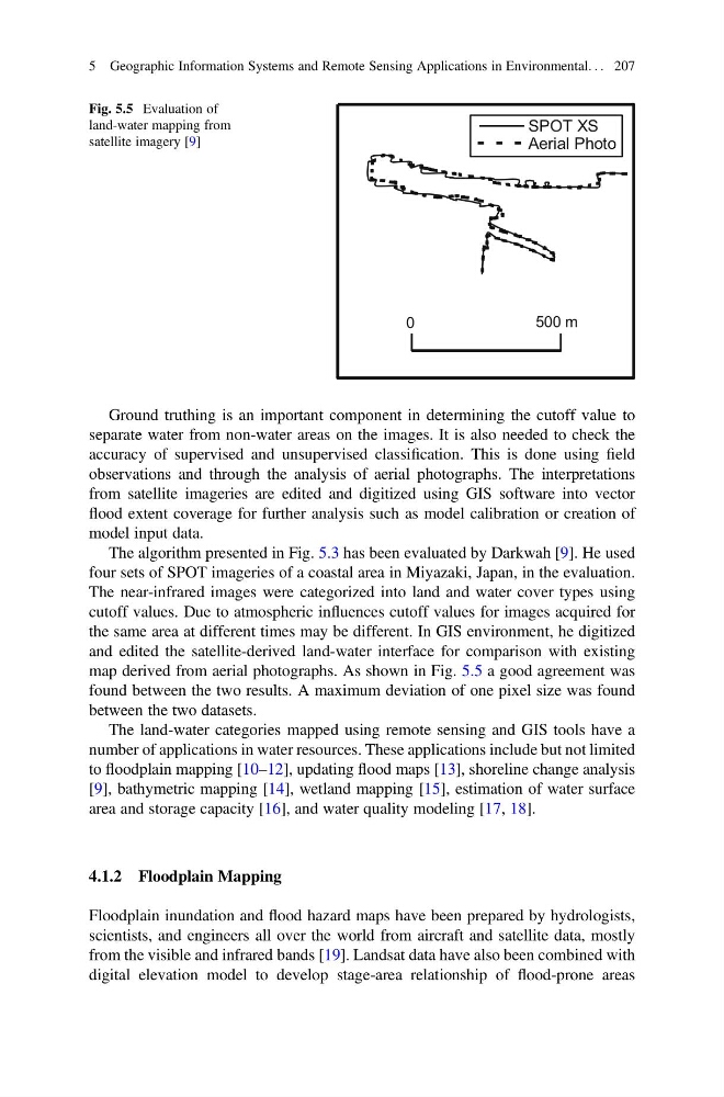
The algorithm presented in Fig. 5.3 has been evaluated by Darkwah [9]. He used
four sets of SPOT imageries of a coastal area in Miyazaki, Japan, in the evaluation.
The near-infrared images were categorized into land and water cover types using
cutoff values. Due to atmospheric influences cutoff values for images acquired for
the same area at different times may be different. In GIS environment, he digitized
and edited the satellite-derived land-water interface for comparison with existing
map derived from aerial photographs. As shown in Fig. 5.5 a good agreement was
found between the two results. A maximum deviation of one pixel size was found
between the two datasets.
The land-water categories mapped using remote sensing and GIS tools have a
number of applications in water resources. These applications include but not limited
to floodplain mapping [10–12], updating flood maps [13], shoreline change analysis
[9], bathymetric mapping [14], wetland mapping [15], estimation of water surface
area and storage capacity [16], and water quality modeling [17, 18].
4.1.2 Floodplain Mapping
Floodplain inundation and flood hazard maps have been prepared by hydrologists,
scientists, and engineers all over the world from aircraft and satellite data, mostly
from the visible and infrared bands [19]. Landsat data have also been combined with
digital elevation model to develop stage-area relationship of flood-prone areas
SPOT XS
Aerial Photo
0
500 m
Fig. 5.5 Evaluation of
land-water mapping from
satellite imagery [9]
5 Geographic Information Systems and Remote Sensing Applications in Environmental. . . 207
separate water from non-water areas on the images. It is also needed to check the
accuracy of supervised and unsupervised classification. This is done using field
observations and through the analysis of aerial photographs. The interpretations
from satellite imageries are edited and digitized using GIS software into vector
flood extent coverage for further analysis such as model calibration or creation of
model input data.
The algorithm presented in Fig. 5.3 has been evaluated by Darkwah [9]. He used
four sets of SPOT imageries of a coastal area in Miyazaki, Japan, in the evaluation.
The near-infrared images were categorized into land and water cover types using
cutoff values. Due to atmospheric influences cutoff values for images acquired for
the same area at different times may be different. In GIS environment, he digitized
and edited the satellite-derived land-water interface for comparison with existing
map derived from aerial photographs. As shown in Fig. 5.5 a good agreement was
found between the two results. A maximum deviation of one pixel size was found
between the two datasets.
The land-water categories mapped using remote sensing and GIS tools have a
number of applications in water resources. These applications include but not limited
to floodplain mapping [10–12], updating flood maps [13], shoreline change analysis
[9], bathymetric mapping [14], wetland mapping [15], estimation of water surface
area and storage capacity [16], and water quality modeling [17, 18].
4.1.2 Floodplain Mapping
Floodplain inundation and flood hazard maps have been prepared by hydrologists,
scientists, and engineers all over the world from aircraft and satellite data, mostly
from the visible and infrared bands [19]. Landsat data have also been combined with
digital elevation model to develop stage-area relationship of flood-prone areas
SPOT XS
Aerial Photo
0
500 m
Fig. 5.5 Evaluation of
land-water mapping from
satellite imagery [9]
5 Geographic Information Systems and Remote Sensing Applications in Environmental. . . 207