

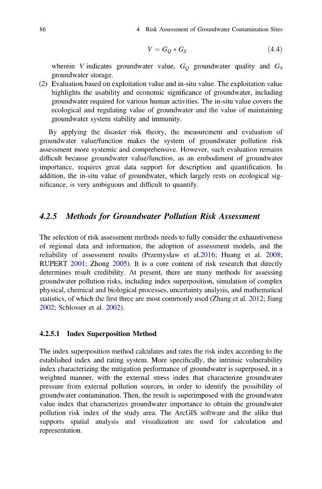
V ¼ G Q Ã G S
ð4:4Þ
wherein V indicates groundwater value, G Q groundwater quality and G S
groundwater storage.
(2) Evaluation based on exploitation value and in-situ value. The exploitation value
highlights the usability and economic significance of groundwater, including
groundwater required for various human activities. The in-situ value covers the
ecological and regulating value of groundwater and the value of maintaining
groundwater system stability and immunity.
By applying the disaster risk theory, the measurement and evaluation of
groundwater value/function makes the system of groundwater pollution risk
assessment more systemic and comprehensive. However, such evaluation remains
difficult because groundwater value/function, as an embodiment of groundwater
importance, requires great data support for description and quantification. In
addition, the in-situ value of groundwater, which largely rests on ecological significance, is very ambiguous and difficult to quantify.
4.2.5 Methods for Groundwater Pollution Risk Assessment
The selection of risk assessment methods needs to fully consider the exhaustiveness
of regional data and information, the adoption of assessment models, and the
reliability of assessment results (Przemysław et al.2016; Huang et al. 2008;
RUPERT 2001; Zhong 2005). It is a core content of risk research that directly
determines result credibility. At present, there are many methods for assessing
groundwater pollution risks, including index superposition, simulation of complex
physical, chemical and biological processes, uncertainty analysis, and mathematical
statistics, of which the first three are most commonly used (Zhang et al. 2012; Jiang
2002; Schlosser et al. 2002).
4.2.5.1 Index Superposition Method
The index superposition method calculates and rates the risk index according to the
established index and rating system. More specifically, the intrinsic vulnerability
index characterizing the mitigation performance of groundwater is superposed, in a
weighted manner, with the external stress index that characterize groundwater
pressure from external pollution sources, in order to identify the possibility of
groundwater contamination. Then, the result is superimposed with the groundwater
value index that characterizes groundwater importance to obtain the groundwater
pollution risk index of the study area. The ArcGIS software and the alike that
supports spatial analysis and visualization are used for calculation and
representation.
86
4 Risk Assessment of Groundwater Contamination Sites
ð4:4Þ
wherein V indicates groundwater value, G Q groundwater quality and G S
groundwater storage.
(2) Evaluation based on exploitation value and in-situ value. The exploitation value
highlights the usability and economic significance of groundwater, including
groundwater required for various human activities. The in-situ value covers the
ecological and regulating value of groundwater and the value of maintaining
groundwater system stability and immunity.
By applying the disaster risk theory, the measurement and evaluation of
groundwater value/function makes the system of groundwater pollution risk
assessment more systemic and comprehensive. However, such evaluation remains
difficult because groundwater value/function, as an embodiment of groundwater
importance, requires great data support for description and quantification. In
addition, the in-situ value of groundwater, which largely rests on ecological significance, is very ambiguous and difficult to quantify.
4.2.5 Methods for Groundwater Pollution Risk Assessment
The selection of risk assessment methods needs to fully consider the exhaustiveness
of regional data and information, the adoption of assessment models, and the
reliability of assessment results (Przemysław et al.2016; Huang et al. 2008;
RUPERT 2001; Zhong 2005). It is a core content of risk research that directly
determines result credibility. At present, there are many methods for assessing
groundwater pollution risks, including index superposition, simulation of complex
physical, chemical and biological processes, uncertainty analysis, and mathematical
statistics, of which the first three are most commonly used (Zhang et al. 2012; Jiang
2002; Schlosser et al. 2002).
4.2.5.1 Index Superposition Method
The index superposition method calculates and rates the risk index according to the
established index and rating system. More specifically, the intrinsic vulnerability
index characterizing the mitigation performance of groundwater is superposed, in a
weighted manner, with the external stress index that characterize groundwater
pressure from external pollution sources, in order to identify the possibility of
groundwater contamination. Then, the result is superimposed with the groundwater
value index that characterizes groundwater importance to obtain the groundwater
pollution risk index of the study area. The ArcGIS software and the alike that
supports spatial analysis and visualization are used for calculation and
representation.
86
4 Risk Assessment of Groundwater Contamination Sites