

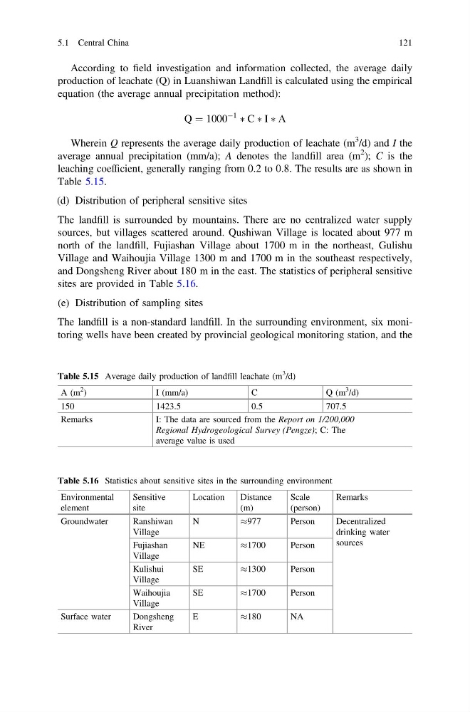
According to field investigation and information collected, the average daily
production of leachate (Q) in Luanshiwan Landfill is calculated using the empirical
equation (the average annual precipitation method):
Q ¼ 1000
À1
à C à I à A
Wherein Q represents the average daily production of leachate (m
3 /d) and I the
average annual precipitation (mm/a); A denotes the landfill area (m
2 ); C is the
leaching coefficient, generally ranging from 0.2 to 0.8. The results are as shown in
Table 5.15.
(d) Distribution of peripheral sensitive sites
The landfill is surrounded by mountains. There are no centralized water supply
sources, but villages scattered around. Qushiwan Village is located about 977 m
north of the landfill, Fujiashan Village about 1700 m in the northeast, Gulishu
Village and Waihoujia Village 1300 m and 1700 m in the southeast respectively,
and Dongsheng River about 180 m in the east. The statistics of peripheral sensitive
sites are provided in Table 5.16.
(e) Distribution of sampling sites
The landfill is a non-standard landfill. In the surrounding environment, six monitoring wells have been created by provincial geological monitoring station, and the
Table 5.15 Average daily production of landfill leachate (m
3
/d)
A (m
2
)
I (mm/a)
C
Q (m
3
/d)
150
1423.5
0.5
707.5
Remarks
I: The data are sourced from the Report on 1/200,000
Regional Hydrogeological Survey (Pengze); C: The
average value is used
Table 5.16 Statistics about sensitive sites in the surrounding environment
Environmental
element
Sensitive
site
Location
Distance
(m)
Scale
(person)
Remarks
Groundwater
Ranshiwan
Village
N
%977
Person
Decentralized
drinking water
sources
Fujiashan
Village
NE
%1700
Person
Kulishui
Village
SE
%1300
Person
Waihoujia
Village
SE
%1700
Person
Surface water
Dongsheng
River
E
%180
NA
5.1 Central China
121
production of leachate (Q) in Luanshiwan Landfill is calculated using the empirical
equation (the average annual precipitation method):
Q ¼ 1000
À1
à C à I à A
Wherein Q represents the average daily production of leachate (m
3 /d) and I the
average annual precipitation (mm/a); A denotes the landfill area (m
2 ); C is the
leaching coefficient, generally ranging from 0.2 to 0.8. The results are as shown in
Table 5.15.
(d) Distribution of peripheral sensitive sites
The landfill is surrounded by mountains. There are no centralized water supply
sources, but villages scattered around. Qushiwan Village is located about 977 m
north of the landfill, Fujiashan Village about 1700 m in the northeast, Gulishu
Village and Waihoujia Village 1300 m and 1700 m in the southeast respectively,
and Dongsheng River about 180 m in the east. The statistics of peripheral sensitive
sites are provided in Table 5.16.
(e) Distribution of sampling sites
The landfill is a non-standard landfill. In the surrounding environment, six monitoring wells have been created by provincial geological monitoring station, and the
Table 5.15 Average daily production of landfill leachate (m
3
/d)
A (m
2
)
I (mm/a)
C
Q (m
3
/d)
150
1423.5
0.5
707.5
Remarks
I: The data are sourced from the Report on 1/200,000
Regional Hydrogeological Survey (Pengze); C: The
average value is used
Table 5.16 Statistics about sensitive sites in the surrounding environment
Environmental
element
Sensitive
site
Location
Distance
(m)
Scale
(person)
Remarks
Groundwater
Ranshiwan
Village
N
%977
Person
Decentralized
drinking water
sources
Fujiashan
Village
NE
%1700
Person
Kulishui
Village
SE
%1300
Person
Waihoujia
Village
SE
%1700
Person
Surface water
Dongsheng
River
E
%180
NA
5.1 Central China
121