

Calibration and Validation of HEC-HMS for Simulation
of Flood Events
The calibrated parameter values of all the subbasins for runoff simulation show that
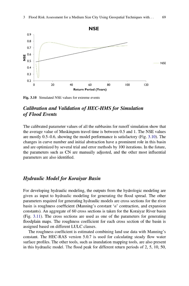
the average value of Muskingum travel time is between 0.5 and 1. The NSE values
are mostly 0.5–0.6, showing the model performance is satisfactory (Fig. 3.10). The
changes in curve number and initial abstraction have a prominent role in this basin
and are optimized by several trial and error methods by 100 iterations. In the future,
the parameters such as CN are manually adjusted, and the other most influential
parameters are also identified.
Hydraulic Model for Koraiyar Basin
For developing hydraulic modeling, the outputs from the hydrologic modeling are
given as input to hydraulic modeling for generating the flood spread. The other
parameters required for generating hydraulic models are cross sections for the river
basin is roughness coefficient (Manning’s constant ‘n’ contraction, and expansion
constants). An aggregate of 60 cross sections is taken for the Koraiyar River basin
(Fig. 3.11). The cross sections are used as one of the parameters for generating
floodplain maps. The roughness coefficient for each cross section of the basin is
assigned based on different LULC classes.
The roughness coefficient is estimated combining land use data with Manning’s
constant. The HEC-RAS version 5.0.7 is used for calculating steady flow water
surface profiles. The other tools, such as inundation mapping tools, are also present
in this hydraulic model. The flood peak for different return periods of 2, 5, 10, 50,
Fig. 3.10 Simulated NSE values for extreme events
3 Flood Risk Assessment for a Medium Size City Using Geospatial Techniques with. . .
69
of Flood Events
The calibrated parameter values of all the subbasins for runoff simulation show that
the average value of Muskingum travel time is between 0.5 and 1. The NSE values
are mostly 0.5–0.6, showing the model performance is satisfactory (Fig. 3.10). The
changes in curve number and initial abstraction have a prominent role in this basin
and are optimized by several trial and error methods by 100 iterations. In the future,
the parameters such as CN are manually adjusted, and the other most influential
parameters are also identified.
Hydraulic Model for Koraiyar Basin
For developing hydraulic modeling, the outputs from the hydrologic modeling are
given as input to hydraulic modeling for generating the flood spread. The other
parameters required for generating hydraulic models are cross sections for the river
basin is roughness coefficient (Manning’s constant ‘n’ contraction, and expansion
constants). An aggregate of 60 cross sections is taken for the Koraiyar River basin
(Fig. 3.11). The cross sections are used as one of the parameters for generating
floodplain maps. The roughness coefficient for each cross section of the basin is
assigned based on different LULC classes.
The roughness coefficient is estimated combining land use data with Manning’s
constant. The HEC-RAS version 5.0.7 is used for calculating steady flow water
surface profiles. The other tools, such as inundation mapping tools, are also present
in this hydraulic model. The flood peak for different return periods of 2, 5, 10, 50,
Fig. 3.10 Simulated NSE values for extreme events
3 Flood Risk Assessment for a Medium Size City Using Geospatial Techniques with. . .
69