

To analyze the LULC classification of the Koraiyar basin image, registration is
the first step, which is applied in satellite images for the image classification analysis
and change detection processes. The ArcGIS software version 10.2.2 is used in this
study, and the base map of the Koraiyar basin is prepared from the DEM by fixing
the outlet point. The map to image registration for the base map is prepared by using
SOI (Survey of India Toposheet) 58 J/9, J/10, J/13, J/14 of the year 1970, and image
registration is done by suitable ground control points (GCPs) with permanent
features such as bridges in the Koraiyar basin. The remote sensing image was then
geo-rectified by using the selected GCPs extracted from the geo-referenced
toposheets. In the image to image registration, the base reference of the study area
is required. The Landsat 4–5 TM image of the year 1986 is used as the base image
for the co-registration of the images of years 1996, 2006, and 2016, so that all the
images would have a uniform projection.The maximum likelihood technique is used
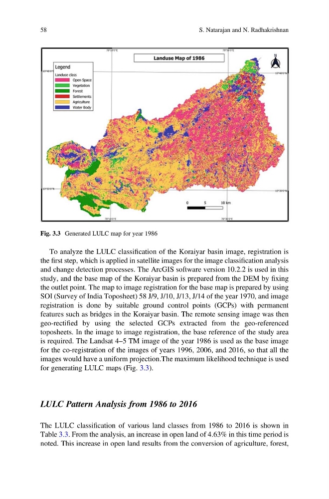
for generating LULC maps (Fig. 3.3).
LULC Pattern Analysis from 1986 to 2016
The LULC classification of various land classes from 1986 to 2016 is shown in
Table 3.3. From the analysis, an increase in open land of 4.63% in this time period is
noted. This increase in open land results from the conversion of agriculture, forest,
Fig. 3.3 Generated LULC map for year 1986
58
S. Natarajan and N. Radhakrishnan
the first step, which is applied in satellite images for the image classification analysis
and change detection processes. The ArcGIS software version 10.2.2 is used in this
study, and the base map of the Koraiyar basin is prepared from the DEM by fixing
the outlet point. The map to image registration for the base map is prepared by using
SOI (Survey of India Toposheet) 58 J/9, J/10, J/13, J/14 of the year 1970, and image
registration is done by suitable ground control points (GCPs) with permanent
features such as bridges in the Koraiyar basin. The remote sensing image was then
geo-rectified by using the selected GCPs extracted from the geo-referenced
toposheets. In the image to image registration, the base reference of the study area
is required. The Landsat 4–5 TM image of the year 1986 is used as the base image
for the co-registration of the images of years 1996, 2006, and 2016, so that all the
images would have a uniform projection.The maximum likelihood technique is used
for generating LULC maps (Fig. 3.3).
LULC Pattern Analysis from 1986 to 2016
The LULC classification of various land classes from 1986 to 2016 is shown in
Table 3.3. From the analysis, an increase in open land of 4.63% in this time period is
noted. This increase in open land results from the conversion of agriculture, forest,
Fig. 3.3 Generated LULC map for year 1986
58
S. Natarajan and N. Radhakrishnan