

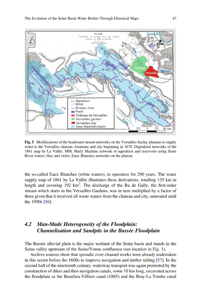
the so-called Eaux Blanches (white waters), in operation for 290 years. The water
supply map of 1861 by La Vallée illustrates these derivations, totalling 135 km in
length and covering 192 km
2 . The discharge of the Ru de Gally, the first-order
stream which starts in the Versailles Gardens, was in turn multiplied by a factor of
three given that it received all waste waters from the chateau and city, untreated until
the 1950s [56].
4.2 Man-Made Heterogeneity of the Floodplain:
Channelisation and Sandpits in the Bassée Floodplain
The Bassée alluvial plain is the major wetland of the Seine basin and stands in the
Seine valley upstream of the Seine/Yonne confluence (see location in Fig. 1).
Archive sources show that sporadic river channel works were already undertaken
in this sector before the 1600s to improve navigation and timber rafting [57]. In the
second half of the nineteenth century, waterway transport was again promoted by the
construction of dikes and then navigation canals, some 10 km long, excavated across
the floodplain as the Beaulieu-Villiers canal (1885) and the Bray-La Tombe canal
Fig. 5 Modifications of the headwater stream networks on the Versailles-Saclay plateaus to supply
water to the Versailles chateau, fountains and city beginning in 1670. Digitalised networks of the
1861 map by La Vallée. MM, Marly Machine network of aqueducts and reservoirs using Seine
River waters; blue and violet, Eaux Blanches networks on the plateau
The Evolution of the Seine Basin Water Bodies Through Historical Maps
47
supply map of 1861 by La Vallée illustrates these derivations, totalling 135 km in
length and covering 192 km
2 . The discharge of the Ru de Gally, the first-order
stream which starts in the Versailles Gardens, was in turn multiplied by a factor of
three given that it received all waste waters from the chateau and city, untreated until
the 1950s [56].
4.2 Man-Made Heterogeneity of the Floodplain:
Channelisation and Sandpits in the Bassée Floodplain
The Bassée alluvial plain is the major wetland of the Seine basin and stands in the
Seine valley upstream of the Seine/Yonne confluence (see location in Fig. 1).
Archive sources show that sporadic river channel works were already undertaken
in this sector before the 1600s to improve navigation and timber rafting [57]. In the
second half of the nineteenth century, waterway transport was again promoted by the
construction of dikes and then navigation canals, some 10 km long, excavated across
the floodplain as the Beaulieu-Villiers canal (1885) and the Bray-La Tombe canal
Fig. 5 Modifications of the headwater stream networks on the Versailles-Saclay plateaus to supply
water to the Versailles chateau, fountains and city beginning in 1670. Digitalised networks of the
1861 map by La Vallée. MM, Marly Machine network of aqueducts and reservoirs using Seine
River waters; blue and violet, Eaux Blanches networks on the plateau
The Evolution of the Seine Basin Water Bodies Through Historical Maps
47