

12.3 Methods and Materials
195
and WS denote those that were not disturbed by mass failures when water erosion
occurred only. In addition, on each model landform, before the first event of rainfall,
soil samples were taken in the depth of 0–5, 40–45 and 120–125 cm from the steep
slope section. After the fifth rainfall, samples were collected from the deposited
sediments on the channel bed. In the experiment, the deposited sediments on the
channel bed were cleared away after each rainfall event, so their thickness was
only about 10 cm at the end of the fifth rainfall. Suspended sediment samples were
collected at the gully and channel outlets, and the deposited sediment samples were
collected in the middle of the channel bed (Fig. 12.1d). Of all the samples collected,
8 were gravity erosion samples (GS), 6 were water erosion samples (WS), 6 were
undisturbed soil samples (US), and 2 were deposited sediment samples (SD). The
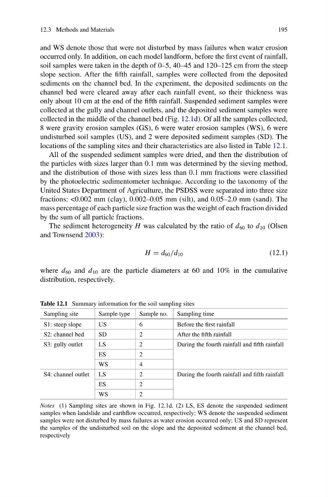
locations of the sampling sites and their characteristics are also listed in Table 12.1.
All of the suspended sediment samples were dried, and then the distribution of
the particles with sizes larger than 0.1 mm was determined by the sieving method,
and the distribution of those with sizes less than 0.1 mm fractions were classified
by the photoelectric sedimentometer technique. According to the taxonomy of the
United States Department of Agriculture, the PSDSS were separated into three size
fractions: <0.002 mm (clay), 0.002–0.05 mm (silt), and 0.05–2.0 mm (sand). The
mass percentage of each particle size fraction was the weight of each fraction divided
by the sum of all particle fractions.
The sediment heterogeneity H was calculated by the ratio of d 60 to d 10 (Olsen
and Townsend 2003):
H = d 60 /d 10
(12.1)
where d 60 and d 10 are the particle diameters at 60 and 10% in the cumulative
distribution, respectively.
Table 12.1 Summary information for the soil sampling sites
Sampling site
Sample type Sample no. Sampling time
S1: steep slope
US
6
Before the first rainfall
S2: channel bed
SD
2
After the fifth rainfall
S3: gully outlet
LS
2
During the fourth rainfall and fifth rainfall
ES
2
WS
4
S4: channel outlet LS
2
During the fourth rainfall and fifth rainfall
ES
2
WS
2
Notes (1) Sampling sites are shown in Fig. 12.1d. (2) LS, ES denote the suspended sediment
samples when landslide and earthflow occurred, respectively; WS denote the suspended sediment
samples were not disturbed by mass failures as water erosion occurred only; US and SD represent
the samples of the undisturbed soil on the slope and the deposited sediment at the channel bed,
respectively
195
and WS denote those that were not disturbed by mass failures when water erosion
occurred only. In addition, on each model landform, before the first event of rainfall,
soil samples were taken in the depth of 0–5, 40–45 and 120–125 cm from the steep
slope section. After the fifth rainfall, samples were collected from the deposited
sediments on the channel bed. In the experiment, the deposited sediments on the
channel bed were cleared away after each rainfall event, so their thickness was
only about 10 cm at the end of the fifth rainfall. Suspended sediment samples were
collected at the gully and channel outlets, and the deposited sediment samples were
collected in the middle of the channel bed (Fig. 12.1d). Of all the samples collected,
8 were gravity erosion samples (GS), 6 were water erosion samples (WS), 6 were
undisturbed soil samples (US), and 2 were deposited sediment samples (SD). The
locations of the sampling sites and their characteristics are also listed in Table 12.1.
All of the suspended sediment samples were dried, and then the distribution of
the particles with sizes larger than 0.1 mm was determined by the sieving method,
and the distribution of those with sizes less than 0.1 mm fractions were classified
by the photoelectric sedimentometer technique. According to the taxonomy of the
United States Department of Agriculture, the PSDSS were separated into three size
fractions: <0.002 mm (clay), 0.002–0.05 mm (silt), and 0.05–2.0 mm (sand). The
mass percentage of each particle size fraction was the weight of each fraction divided
by the sum of all particle fractions.
The sediment heterogeneity H was calculated by the ratio of d 60 to d 10 (Olsen
and Townsend 2003):
H = d 60 /d 10
(12.1)
where d 60 and d 10 are the particle diameters at 60 and 10% in the cumulative
distribution, respectively.
Table 12.1 Summary information for the soil sampling sites
Sampling site
Sample type Sample no. Sampling time
S1: steep slope
US
6
Before the first rainfall
S2: channel bed
SD
2
After the fifth rainfall
S3: gully outlet
LS
2
During the fourth rainfall and fifth rainfall
ES
2
WS
4
S4: channel outlet LS
2
During the fourth rainfall and fifth rainfall
ES
2
WS
2
Notes (1) Sampling sites are shown in Fig. 12.1d. (2) LS, ES denote the suspended sediment
samples when landslide and earthflow occurred, respectively; WS denote the suspended sediment
samples were not disturbed by mass failures as water erosion occurred only; US and SD represent
the samples of the undisturbed soil on the slope and the deposited sediment at the channel bed,
respectively