

194
12 Effects of Gravity Erosion on Particle Size Distribution …
Rainfall
Tableland
Mass movement
Steep slope
Gully
(c)
Channel
Tableland
Gully
Steep slope
Channel
Mass movement
(d)
S3
S2
S4
S1
T1
(a)
(b)
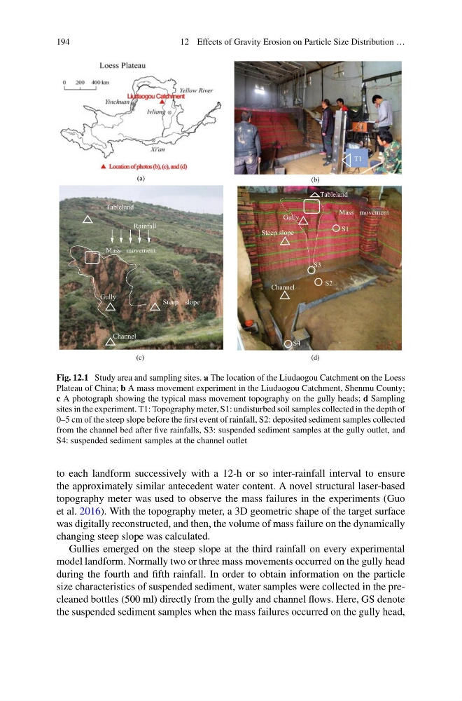
Fig. 12.1 Study area and sampling sites. a The location of the Liudaogou Catchment on the Loess
Plateau of China; b A mass movement experiment in the Liudaogou Catchment, Shenmu County;
c A photograph showing the typical mass movement topography on the gully heads; d Sampling
sites in the experiment. T1: Topography meter, S1: undisturbed soil samples collected in the depth of
0–5 cm of the steep slope before the first event of rainfall, S2: deposited sediment samples collected
from the channel bed after five rainfalls, S3: suspended sediment samples at the gully outlet, and
S4: suspended sediment samples at the channel outlet
to each landform successively with a 12-h or so inter-rainfall interval to ensure
the approximately similar antecedent water content. A novel structural laser-based
topography meter was used to observe the mass failures in the experiments (Guo
et al. 2016). With the topography meter, a 3D geometric shape of the target surface
was digitally reconstructed, and then, the volume of mass failure on the dynamically
changing steep slope was calculated.
Gullies emerged on the steep slope at the third rainfall on every experimental
model landform. Normally two or three mass movements occurred on the gully head
during the fourth and fifth rainfall. In order to obtain information on the particle
size characteristics of suspended sediment, water samples were collected in the precleaned bottles (500 ml) directly from the gully and channel flows. Here, GS denote
the suspended sediment samples when the mass failures occurred on the gully head,
12 Effects of Gravity Erosion on Particle Size Distribution …
Rainfall
Tableland
Mass movement
Steep slope
Gully
(c)
Channel
Tableland
Gully
Steep slope
Channel
Mass movement
(d)
S3
S2
S4
S1
T1
(a)
(b)
Fig. 12.1 Study area and sampling sites. a The location of the Liudaogou Catchment on the Loess
Plateau of China; b A mass movement experiment in the Liudaogou Catchment, Shenmu County;
c A photograph showing the typical mass movement topography on the gully heads; d Sampling
sites in the experiment. T1: Topography meter, S1: undisturbed soil samples collected in the depth of
0–5 cm of the steep slope before the first event of rainfall, S2: deposited sediment samples collected
from the channel bed after five rainfalls, S3: suspended sediment samples at the gully outlet, and
S4: suspended sediment samples at the channel outlet
to each landform successively with a 12-h or so inter-rainfall interval to ensure
the approximately similar antecedent water content. A novel structural laser-based
topography meter was used to observe the mass failures in the experiments (Guo
et al. 2016). With the topography meter, a 3D geometric shape of the target surface
was digitally reconstructed, and then, the volume of mass failure on the dynamically
changing steep slope was calculated.
Gullies emerged on the steep slope at the third rainfall on every experimental
model landform. Normally two or three mass movements occurred on the gully head
during the fourth and fifth rainfall. In order to obtain information on the particle
size characteristics of suspended sediment, water samples were collected in the precleaned bottles (500 ml) directly from the gully and channel flows. Here, GS denote
the suspended sediment samples when the mass failures occurred on the gully head,