

116
8 Sediment-Storage Effects of Check-Dam …
several inherent advantages such as (a) to give insight into problems which cannot be
solved theoretically or numerically; (b) to get better control of boundary conditions;
and (c) to save time and money (Timmons 1984). The accuracy of such predictions
depends on the similarity between model and prototype in three principal characteristics: (a) geometric similitude; (b) kinematic similitude; and (c) dynamic similitude.
While some similarity requirements appear to have been firmly established, others
have not been fixed (Zhang et al. 1994; Timmons 1984).
Scaled modeling has been widely used for a long time in the field of hydraulics and
river engineering (e.g., Zhang et al. 1994). However, few studies simulated the process
of soil loss using a scaled model experiment, as such simulation is quite complicated
in that rainfall, soil surface crusting, land-use and vegetation cover, etc., should be
considered. Hancock and Willgoose (2004) investigated the effect of erosion on a
back-filled and capped earthen dam wall by constructing an experimental model
landscape simulator in a laboratory. The design of the rainfall simulator was difficult
to directly scale the rainfall runoff processes to the field conditions. Consequently,
no attempt was made to match the rate of gully development on the tailings dam to
field-scale processes. Scaled model experiments for soil and water erosion in small
watersheds have recently been conducted and progress has been made in applying
similitude methodology. Shi et al. (1997a, b) observed the quantitative erosion in
gullies and on slopes in a small watershed model of the landform of Xiaofanjiagou
Gully in Shaanxi Province (the length scale was 75). Jiang et al. (1994) and Yuan
et al. (2000a, b) who carried out a series of model experiments for different degrees
of erosion control in a small watershed on the Loess Plateau investigated the relation
between runoff and sedimentation. Rainfall and soils similar to those of the prototype
were applied, and the landforms were scaled. Nevertheless, none of these studies used
an explicit scale relation between the prototype and the model.
Xu and Zhang (2004) presented a new method to simulate soil and water processes
in small watersheds of the Loess Plateau, and has tested the method using serial model
experiments. For this method, the ratio of model geomorphological evolvement rate
to the corresponding prototype evolvement rate is kept constant so that soil and water
erosion processes of the prototype can be reflected by model experimental results. In
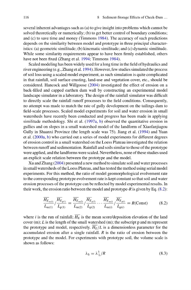
their work, the erosion ratio between the model and prototype-R is given by Eq. (8.2):
H E m(1)
L m(1)
/
H E p(1)
L p(1)
=
H E m(2)
L m(2)
/
H E p(2)
L p(2)
· · ·
H E m(i)
L m(i)
/
H E p(i)
L p(i)
= R(Const)
(8.2)
where i is the run of rainfall; H E is the mean score/deposition elevation of the land
cover (m); L is the length of the small watershed (m); the subscript p and m represent
the prototype and model, respectively. H E /L is a dimensionless parameter for the
accumulated erosion after a single rainfall. R is the ratio of erosion between the
prototype and the model. For experiments with prototype soil, the volume scale is
shown as follows:
λ S = λ
3
L /R
(8.3)
8 Sediment-Storage Effects of Check-Dam …
several inherent advantages such as (a) to give insight into problems which cannot be
solved theoretically or numerically; (b) to get better control of boundary conditions;
and (c) to save time and money (Timmons 1984). The accuracy of such predictions
depends on the similarity between model and prototype in three principal characteristics: (a) geometric similitude; (b) kinematic similitude; and (c) dynamic similitude.
While some similarity requirements appear to have been firmly established, others
have not been fixed (Zhang et al. 1994; Timmons 1984).
Scaled modeling has been widely used for a long time in the field of hydraulics and
river engineering (e.g., Zhang et al. 1994). However, few studies simulated the process
of soil loss using a scaled model experiment, as such simulation is quite complicated
in that rainfall, soil surface crusting, land-use and vegetation cover, etc., should be
considered. Hancock and Willgoose (2004) investigated the effect of erosion on a
back-filled and capped earthen dam wall by constructing an experimental model
landscape simulator in a laboratory. The design of the rainfall simulator was difficult
to directly scale the rainfall runoff processes to the field conditions. Consequently,
no attempt was made to match the rate of gully development on the tailings dam to
field-scale processes. Scaled model experiments for soil and water erosion in small
watersheds have recently been conducted and progress has been made in applying
similitude methodology. Shi et al. (1997a, b) observed the quantitative erosion in
gullies and on slopes in a small watershed model of the landform of Xiaofanjiagou
Gully in Shaanxi Province (the length scale was 75). Jiang et al. (1994) and Yuan
et al. (2000a, b) who carried out a series of model experiments for different degrees
of erosion control in a small watershed on the Loess Plateau investigated the relation
between runoff and sedimentation. Rainfall and soils similar to those of the prototype
were applied, and the landforms were scaled. Nevertheless, none of these studies used
an explicit scale relation between the prototype and the model.
Xu and Zhang (2004) presented a new method to simulate soil and water processes
in small watersheds of the Loess Plateau, and has tested the method using serial model
experiments. For this method, the ratio of model geomorphological evolvement rate
to the corresponding prototype evolvement rate is kept constant so that soil and water
erosion processes of the prototype can be reflected by model experimental results. In
their work, the erosion ratio between the model and prototype-R is given by Eq. (8.2):
H E m(1)
L m(1)
/
H E p(1)
L p(1)
=
H E m(2)
L m(2)
/
H E p(2)
L p(2)
· · ·
H E m(i)
L m(i)
/
H E p(i)
L p(i)
= R(Const)
(8.2)
where i is the run of rainfall; H E is the mean score/deposition elevation of the land
cover (m); L is the length of the small watershed (m); the subscript p and m represent
the prototype and model, respectively. H E /L is a dimensionless parameter for the
accumulated erosion after a single rainfall. R is the ratio of erosion between the
prototype and the model. For experiments with prototype soil, the volume scale is
shown as follows:
λ S = λ
3
L /R
(8.3)