

296
Latitude and 88°10′E–92°15′E Longitude). 68% of Sundarbans lies within
Bangladesh, while 38% lies within the Indian sub-continent. The Indian part of
Sundarban is comprised of 102 islands; of which 54 islands are inhabited by human
civilization whereby more than 45 lakhs people habitat and the rest is reserve mangrove forest. The Indian region is demarcated by the River Hooghly on the west, the
Bay of Bengal on the south, the Ichamati-Kalindi -Raimongal Rivers on the east and
the Dampier-Hodges line on the north. It comprises of 19 Community Development
blocks of which 6 in North and 13 in South 24-Parganas districts that comprises of
190 Gram Panchayats and 1064 villages in total.
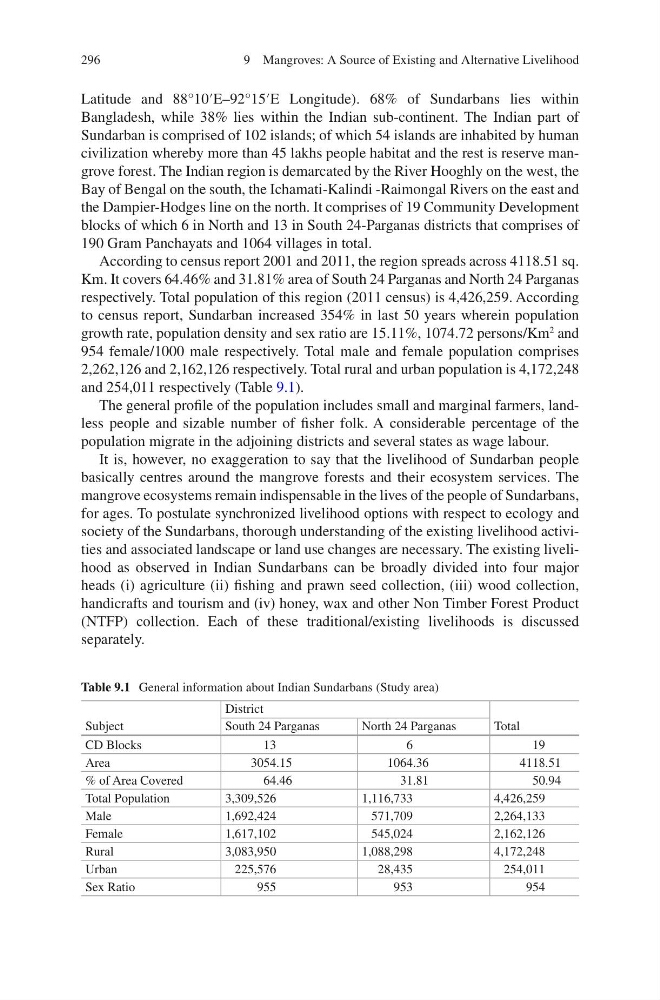
According to census report 2001 and 2011, the region spreads across 4118.51 sq.
Km. It covers 64.46% and 31.81% area of South 24 Parganas and North 24 Parganas
respectively. Total population of this region (2011 census) is 4,426,259. According
to census report, Sundarban increased 354% in last 50 years wherein population
growth rate, population density and sex ratio are 15.11%, 1074.72 persons/Km
2
and
954 female/1000 male respectively. Total male and female population comprises
2,262,126 and 2,162,126 respectively. Total rural and urban population is 4,172,248
and 254,011 respectively (Table 9.1).
The general profile of the population includes small and marginal farmers, landless people and sizable number of fisher folk. A considerable percentage of the
population migrate in the adjoining districts and several states as wage labour.
It is, however, no exaggeration to say that the livelihood of Sundarban people
basically centres around the mangrove forests and their ecosystem services. The
mangrove ecosystems remain indispensable in the lives of the people of Sundarbans,
for ages. To postulate synchronized livelihood options with respect to ecology and
society of the Sundarbans, thorough understanding of the existing livelihood activities and associated landscape or land use changes are necessary. The existing livelihood as observed in Indian Sundarbans can be broadly divided into four major
heads (i) agriculture (ii) fishing and prawn seed collection, (iii) wood collection,
handicrafts and tourism and (iv) honey, wax and other Non Timber Forest Product
(NTFP) collection. Each of these traditional/existing livelihoods is discussed
separately.
Table 9.1 General information about Indian Sundarbans (Study area)
Subject
District
Total
South 24 Parganas
North 24 Parganas
CD Blocks
13
6
19
Area
3054.15
1064.36
4118.51
% of Area Covered
64.46
31.81
50.94
Total Population
3,309,526
1,116,733
4,426,259
Male
1,692,424
571,709
2,264,133
Female
1,617,102
545,024
2,162,126
Rural
3,083,950
1,088,298
4,172,248
Urban
225,576
28,435
254,011
Sex Ratio
955
953
954
9 Mangroves: A Source of Existing and Alternative Livelihood
Latitude and 88°10′E–92°15′E Longitude). 68% of Sundarbans lies within
Bangladesh, while 38% lies within the Indian sub-continent. The Indian part of
Sundarban is comprised of 102 islands; of which 54 islands are inhabited by human
civilization whereby more than 45 lakhs people habitat and the rest is reserve mangrove forest. The Indian region is demarcated by the River Hooghly on the west, the
Bay of Bengal on the south, the Ichamati-Kalindi -Raimongal Rivers on the east and
the Dampier-Hodges line on the north. It comprises of 19 Community Development
blocks of which 6 in North and 13 in South 24-Parganas districts that comprises of
190 Gram Panchayats and 1064 villages in total.
According to census report 2001 and 2011, the region spreads across 4118.51 sq.
Km. It covers 64.46% and 31.81% area of South 24 Parganas and North 24 Parganas
respectively. Total population of this region (2011 census) is 4,426,259. According
to census report, Sundarban increased 354% in last 50 years wherein population
growth rate, population density and sex ratio are 15.11%, 1074.72 persons/Km
2
and
954 female/1000 male respectively. Total male and female population comprises
2,262,126 and 2,162,126 respectively. Total rural and urban population is 4,172,248
and 254,011 respectively (Table 9.1).
The general profile of the population includes small and marginal farmers, landless people and sizable number of fisher folk. A considerable percentage of the
population migrate in the adjoining districts and several states as wage labour.
It is, however, no exaggeration to say that the livelihood of Sundarban people
basically centres around the mangrove forests and their ecosystem services. The
mangrove ecosystems remain indispensable in the lives of the people of Sundarbans,
for ages. To postulate synchronized livelihood options with respect to ecology and
society of the Sundarbans, thorough understanding of the existing livelihood activities and associated landscape or land use changes are necessary. The existing livelihood as observed in Indian Sundarbans can be broadly divided into four major
heads (i) agriculture (ii) fishing and prawn seed collection, (iii) wood collection,
handicrafts and tourism and (iv) honey, wax and other Non Timber Forest Product
(NTFP) collection. Each of these traditional/existing livelihoods is discussed
separately.
Table 9.1 General information about Indian Sundarbans (Study area)
Subject
District
Total
South 24 Parganas
North 24 Parganas
CD Blocks
13
6
19
Area
3054.15
1064.36
4118.51
% of Area Covered
64.46
31.81
50.94
Total Population
3,309,526
1,116,733
4,426,259
Male
1,692,424
571,709
2,264,133
Female
1,617,102
545,024
2,162,126
Rural
3,083,950
1,088,298
4,172,248
Urban
225,576
28,435
254,011
Sex Ratio
955
953
954
9 Mangroves: A Source of Existing and Alternative Livelihood