

297
Agriculture
In the domain of agriculture, paddy monoculture dominates the entire landscape
along with the cultivation of seasonal vegetables like watermelon, oil seeds, chilly
etc. There is great scope of growing salt tolerant varieties of rice in this deltaic complex. After the occurrence of Aila (a super cyclone) during May, 2009, the salinity
of Sundarbans has increased many folds. A study conducted by me before, during
and after the occurrence of the super cyclone in 12 stations in and around the Indian
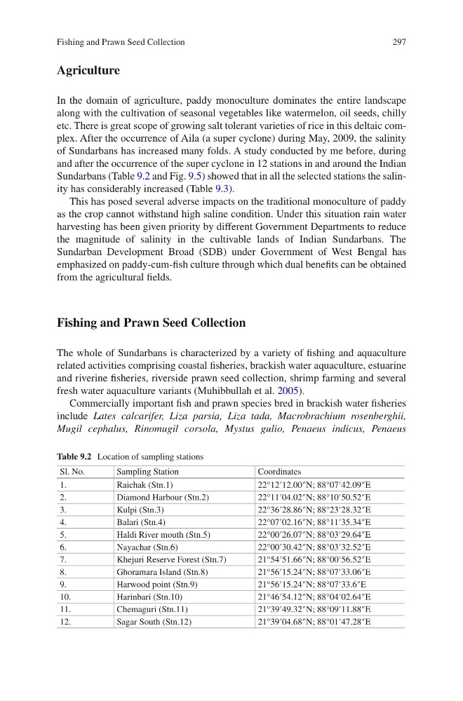
Sundarbans (Table 9.2 and Fig. 9.5) showed that in all the selected stations the salinity has considerably increased (Table 9.3).
This has posed several adverse impacts on the traditional monoculture of paddy
as the crop cannot withstand high saline condition. Under this situation rain water
harvesting has been given priority by different Government Departments to reduce
the magnitude of salinity in the cultivable lands of Indian Sundarbans. The
Sundarban Development Broad (SDB) under Government of West Bengal has
emphasized on paddy-cum-fish culture through which dual benefits can be obtained
from the agricultural fields.
Fishing and Prawn Seed Collection
The whole of Sundarbans is characterized by a variety of fishing and aquaculture
related activities comprising coastal fisheries, brackish water aquaculture, estuarine
and riverine fisheries, riverside prawn seed collection, shrimp farming and several
fresh water aquaculture variants (Muhibbullah et al. 2005).
Commercially important fish and prawn species bred in brackish water fisheries
include Lates calcarifer, Liza parsia, Liza tada, Macrobrachium rosenberghii,
Mugil cephalus, Rinomugil corsola, Mystus gulio, Penaeus indicus, Penaeus
Table 9.2 Location of sampling stations
Sl. No.
Sampling Station
Coordinates
1.
Raichak (Stn.1)
22°12′12.00″N; 88°07′42.09″E
2.
Diamond Harbour (Stn.2)
22°11′04.02″N; 88°10′50.52″E
3.
Kulpi (Stn.3)
22°36′28.86″N; 88°23′28.32″E
4.
Balari (Stn.4)
22°07′02.16″N; 88°11′35.34″E
5.
Haldi River mouth (Stn.5)
22°00′26.07″N; 88°03′29.64″E
6.
Nayachar (Stn.6)
22°00′30.42″N; 88°03′32.52″E
7.
Khejuri Reserve Forest (Stn.7)
21°54′51.66″N; 88°00′56.52″E
8.
Ghoramara Island (Stn.8)
21°56′15.24″N; 88°07′33.06″E
9.
Harwood point (Stn.9)
21°56′15.24″N; 88°07′33.6″E
10.
Harinbari (Stn.10)
21°46′54.12″N; 88°04′02.64″E
11.
Chemaguri (Stn.11)
21°39′49.32″N; 88°09′11.88″E
12.
Sagar South (Stn.12)
21°39′04.68″N; 88°01′47.28″E
Fishing and Prawn Seed Collection
Agriculture
In the domain of agriculture, paddy monoculture dominates the entire landscape
along with the cultivation of seasonal vegetables like watermelon, oil seeds, chilly
etc. There is great scope of growing salt tolerant varieties of rice in this deltaic complex. After the occurrence of Aila (a super cyclone) during May, 2009, the salinity
of Sundarbans has increased many folds. A study conducted by me before, during
and after the occurrence of the super cyclone in 12 stations in and around the Indian
Sundarbans (Table 9.2 and Fig. 9.5) showed that in all the selected stations the salinity has considerably increased (Table 9.3).
This has posed several adverse impacts on the traditional monoculture of paddy
as the crop cannot withstand high saline condition. Under this situation rain water
harvesting has been given priority by different Government Departments to reduce
the magnitude of salinity in the cultivable lands of Indian Sundarbans. The
Sundarban Development Broad (SDB) under Government of West Bengal has
emphasized on paddy-cum-fish culture through which dual benefits can be obtained
from the agricultural fields.
Fishing and Prawn Seed Collection
The whole of Sundarbans is characterized by a variety of fishing and aquaculture
related activities comprising coastal fisheries, brackish water aquaculture, estuarine
and riverine fisheries, riverside prawn seed collection, shrimp farming and several
fresh water aquaculture variants (Muhibbullah et al. 2005).
Commercially important fish and prawn species bred in brackish water fisheries
include Lates calcarifer, Liza parsia, Liza tada, Macrobrachium rosenberghii,
Mugil cephalus, Rinomugil corsola, Mystus gulio, Penaeus indicus, Penaeus
Table 9.2 Location of sampling stations
Sl. No.
Sampling Station
Coordinates
1.
Raichak (Stn.1)
22°12′12.00″N; 88°07′42.09″E
2.
Diamond Harbour (Stn.2)
22°11′04.02″N; 88°10′50.52″E
3.
Kulpi (Stn.3)
22°36′28.86″N; 88°23′28.32″E
4.
Balari (Stn.4)
22°07′02.16″N; 88°11′35.34″E
5.
Haldi River mouth (Stn.5)
22°00′26.07″N; 88°03′29.64″E
6.
Nayachar (Stn.6)
22°00′30.42″N; 88°03′32.52″E
7.
Khejuri Reserve Forest (Stn.7)
21°54′51.66″N; 88°00′56.52″E
8.
Ghoramara Island (Stn.8)
21°56′15.24″N; 88°07′33.06″E
9.
Harwood point (Stn.9)
21°56′15.24″N; 88°07′33.6″E
10.
Harinbari (Stn.10)
21°46′54.12″N; 88°04′02.64″E
11.
Chemaguri (Stn.11)
21°39′49.32″N; 88°09′11.88″E
12.
Sagar South (Stn.12)
21°39′04.68″N; 88°01′47.28″E
Fishing and Prawn Seed Collection