

Vol.:(0123456789)
SN Applied Sciences
(2023) 5:158
| https://doi.org/10.1007/s42452-023-05376-x
Research Article
the golf of Arzew to date and can serve as a reference for
future studies.
2.1.2 Sensitivity maps
Shoreline mapping gives critical information on the sorts
of shorelines (sandy, muddy, rocky) and the species present there to identify biologically susceptible to oil spills
and culturally important locations along the coastline.
Recent maps of coastal vulnerability to pollution were
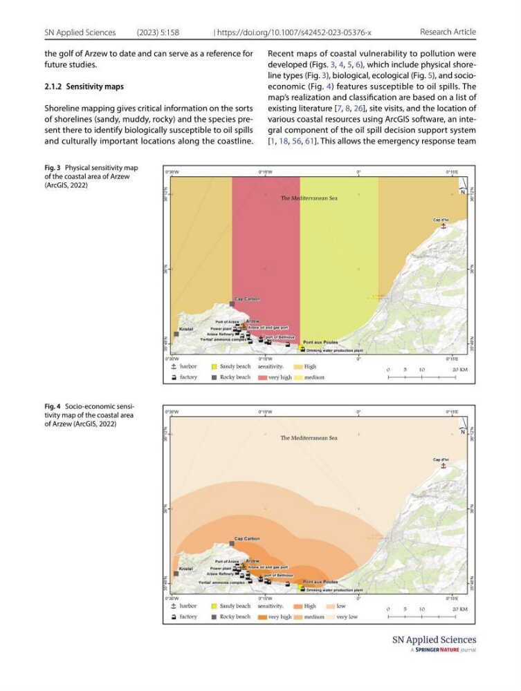
developed (Figs. 3, 4, 5, 6), which include physical shoreline types (Fig. 3), biological, ecological (Fig. 5), and socioeconomic (Fig. 4) features susceptible to oil spills. The
map’s realization and classification are based on a list of
existing literature [7, 8, 26], site visits, and the location of
various coastal resources using ArcGIS software, an integral component of the oil spill decision support system
[1, 18, 56, 61]. This allows the emergency response team
Fig. 3 Physical sensitivity map
of the coastal area of Arzew
(ArcGIS, 2022)
Fig. 4 Socio-economic sensitivity map of the coastal area
of Arzew (ArcGIS, 2022)
SN Applied Sciences
(2023) 5:158
| https://doi.org/10.1007/s42452-023-05376-x
Research Article
the golf of Arzew to date and can serve as a reference for
future studies.
2.1.2 Sensitivity maps
Shoreline mapping gives critical information on the sorts
of shorelines (sandy, muddy, rocky) and the species present there to identify biologically susceptible to oil spills
and culturally important locations along the coastline.
Recent maps of coastal vulnerability to pollution were
developed (Figs. 3, 4, 5, 6), which include physical shoreline types (Fig. 3), biological, ecological (Fig. 5), and socioeconomic (Fig. 4) features susceptible to oil spills. The
map’s realization and classification are based on a list of
existing literature [7, 8, 26], site visits, and the location of
various coastal resources using ArcGIS software, an integral component of the oil spill decision support system
[1, 18, 56, 61]. This allows the emergency response team
Fig. 3 Physical sensitivity map
of the coastal area of Arzew
(ArcGIS, 2022)
Fig. 4 Socio-economic sensitivity map of the coastal area
of Arzew (ArcGIS, 2022)