

Vol:.(1234567890)
Research Article
SN Applied Sciences
(2023) 5:158
| https://doi.org/10.1007/s42452-023-05376-x
Bethioua are Crude Oil Tanker (24%), LPG Tanker (21%),
Bulk Carrier (15%), General Cargo (13%), Oil/Chemical
Tanker (7%). The maximum length of the vessels recorded
to have entered this port is 298 m. The maximum draught
is 15 m. The maximum Deadweight is 174008 t.
2.1.1 Transport of hydrocarbons in the Gulf of Arzew
Maritime traffic is very dense (nearly 40% of the world’s
commercial maritime traffic passes through our coasts) in
addition to 100 million tons of oil exported annually by
Algeria, which also receives refined products through its
terminals in Algiers and Arzew (Table 2) [65]. The port of
Arzew is the first Algerian port for hydrocarbon exploration. Its main role is to load the different ships (oil tankers, LNG ships, LPG ships, chemical tankers) from different
world regions with crude oil and refined products. These
activities generate serious environmental pollution risks
[65]. Table 2 lists the main indicators of the port activity in
Arzew and Bethioua.
Major accidents have occurred in the port of Bethioua
with the following outstanding facts: devastating and
heavy consequences on the human, environmental and
material plateau, recurrence in their occurrences. Hence,
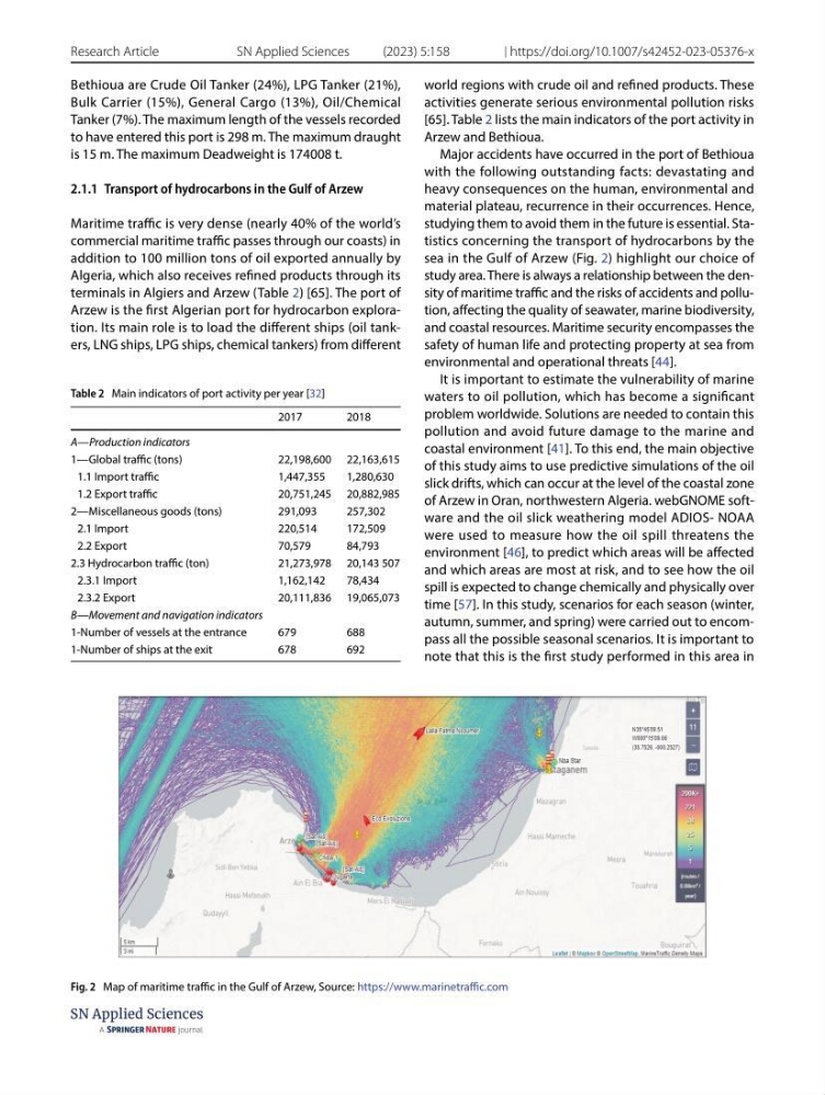
studying them to avoid them in the future is essential. Statistics concerning the transport of hydrocarbons by the
sea in the Gulf of Arzew (Fig. 2) highlight our choice of
study area. There is always a relationship between the density of maritime traffic and the risks of accidents and pollution, affecting the quality of seawater, marine biodiversity,
and coastal resources. Maritime security encompasses the
safety of human life and protecting property at sea from
environmental and operational threats [44].
It is important to estimate the vulnerability of marine
waters to oil pollution, which has become a significant
problem worldwide. Solutions are needed to contain this
pollution and avoid future damage to the marine and
coastal environment [41]. To this end, the main objective
of this study aims to use predictive simulations of the oil
slick drifts, which can occur at the level of the coastal zone
of Arzew in Oran, northwestern Algeria. webGNOME software and the oil slick weathering model ADIOS- NOAA
were used to measure how the oil spill threatens the
environment [46], to predict which areas will be affected
and which areas are most at risk, and to see how the oil
spill is expected to change chemically and physically over
time [57]. In this study, scenarios for each season (winter,
autumn, summer, and spring) were carried out to encompass all the possible seasonal scenarios. It is important to
note that this is the first study performed in this area in
Table 2 Main indicators of port activity per year [32]
2017
2018
A—Production indicators
1—Global traffic (tons)
22,198,600 22,163,615
1.1 Import traffic
1,447,355
1,280,630
1.2 Export traffic
20,751,245 20,882,985
2—Miscellaneous goods (tons)
291,093
257,302
2.1 Import
220,514
172,509
2.2 Export
70,579
84,793
2.3 Hydrocarbon traffic (ton)
21,273,978 20,143 507
2.3.1 Import
1,162,142
78,434
2.3.2 Export
20,111,836 19,065,073
B—Movement and navigation indicators
1-Number of vessels at the entrance
679
688
1-Number of ships at the exit
678
692
Fig. 2 Map of maritime traffic in the Gulf of Arzew, Source: https:// www. marin etraffi c. com
Research Article
SN Applied Sciences
(2023) 5:158
| https://doi.org/10.1007/s42452-023-05376-x
Bethioua are Crude Oil Tanker (24%), LPG Tanker (21%),
Bulk Carrier (15%), General Cargo (13%), Oil/Chemical
Tanker (7%). The maximum length of the vessels recorded
to have entered this port is 298 m. The maximum draught
is 15 m. The maximum Deadweight is 174008 t.
2.1.1 Transport of hydrocarbons in the Gulf of Arzew
Maritime traffic is very dense (nearly 40% of the world’s
commercial maritime traffic passes through our coasts) in
addition to 100 million tons of oil exported annually by
Algeria, which also receives refined products through its
terminals in Algiers and Arzew (Table 2) [65]. The port of
Arzew is the first Algerian port for hydrocarbon exploration. Its main role is to load the different ships (oil tankers, LNG ships, LPG ships, chemical tankers) from different
world regions with crude oil and refined products. These
activities generate serious environmental pollution risks
[65]. Table 2 lists the main indicators of the port activity in
Arzew and Bethioua.
Major accidents have occurred in the port of Bethioua
with the following outstanding facts: devastating and
heavy consequences on the human, environmental and
material plateau, recurrence in their occurrences. Hence,
studying them to avoid them in the future is essential. Statistics concerning the transport of hydrocarbons by the
sea in the Gulf of Arzew (Fig. 2) highlight our choice of
study area. There is always a relationship between the density of maritime traffic and the risks of accidents and pollution, affecting the quality of seawater, marine biodiversity,
and coastal resources. Maritime security encompasses the
safety of human life and protecting property at sea from
environmental and operational threats [44].
It is important to estimate the vulnerability of marine
waters to oil pollution, which has become a significant
problem worldwide. Solutions are needed to contain this
pollution and avoid future damage to the marine and
coastal environment [41]. To this end, the main objective
of this study aims to use predictive simulations of the oil
slick drifts, which can occur at the level of the coastal zone
of Arzew in Oran, northwestern Algeria. webGNOME software and the oil slick weathering model ADIOS- NOAA
were used to measure how the oil spill threatens the
environment [46], to predict which areas will be affected
and which areas are most at risk, and to see how the oil
spill is expected to change chemically and physically over
time [57]. In this study, scenarios for each season (winter,
autumn, summer, and spring) were carried out to encompass all the possible seasonal scenarios. It is important to
note that this is the first study performed in this area in
Table 2 Main indicators of port activity per year [32]
2017
2018
A—Production indicators
1—Global traffic (tons)
22,198,600 22,163,615
1.1 Import traffic
1,447,355
1,280,630
1.2 Export traffic
20,751,245 20,882,985
2—Miscellaneous goods (tons)
291,093
257,302
2.1 Import
220,514
172,509
2.2 Export
70,579
84,793
2.3 Hydrocarbon traffic (ton)
21,273,978 20,143 507
2.3.1 Import
1,162,142
78,434
2.3.2 Export
20,111,836 19,065,073
B—Movement and navigation indicators
1-Number of vessels at the entrance
679
688
1-Number of ships at the exit
678
692
Fig. 2 Map of maritime traffic in the Gulf of Arzew, Source: https:// www. marin etraffi c. com