

Vol.:(0123456789)
SN Applied Sciences
(2023) 5:158
| https://doi.org/10.1007/s42452-023-05376-x
Research Article
politically, and strategically located on one of the Mediterranean Sea’s main coastlines. Indeed, it is strategically
located in the Western Mediterranean. It is the largest
country in the Mediterranean, with a surface area of 2.4
million km
2
, or about 4.5 times the size of France and 8
times the size of Italy, and has a maritime facade of about
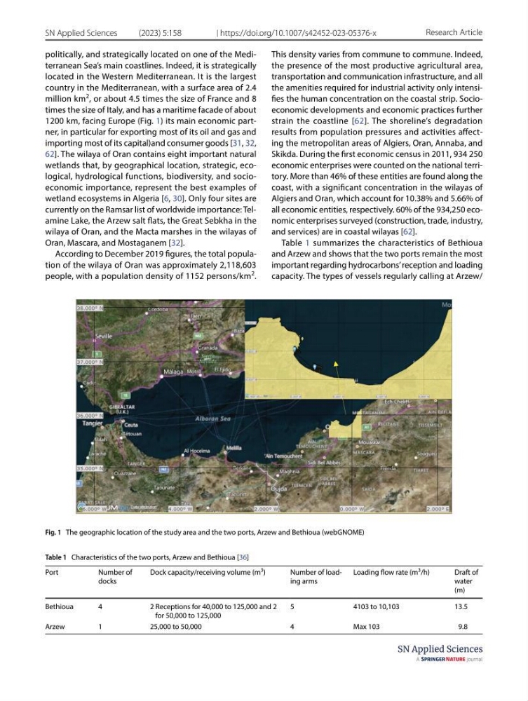
1200 km, facing Europe (Fig. 1) its main economic partner, in particular for exporting most of its oil and gas and
importing most of its capital)and consumer goods [31, 32,
62]. The wilaya of Oran contains eight important natural
wetlands that, by geographical location, strategic, ecological, hydrological functions, biodiversity, and socioeconomic importance, represent the best examples of
wetland ecosystems in Algeria [6, 30]. Only four sites are
currently on the Ramsar list of worldwide importance: Telamine Lake, the Arzew salt flats, the Great Sebkha in the
wilaya of Oran, and the Macta marshes in the wilayas of
Oran, Mascara, and Mostaganem [32].
According to December 2019 figures, the total population of the wilaya of Oran was approximately 2,118,603
people, with a population density of 1152 persons/km
2
.
This density varies from commune to commune. Indeed,
the presence of the most productive agricultural area,
transportation and communication infrastructure, and all
the amenities required for industrial activity only intensifies the human concentration on the coastal strip. Socioeconomic developments and economic practices further
strain the coastline [62]. The shoreline’s degradation
results from population pressures and activities affecting the metropolitan areas of Algiers, Oran, Annaba, and
Skikda. During the first economic census in 2011, 934 250
economic enterprises were counted on the national territory. More than 46% of these entities are found along the
coast, with a significant concentration in the wilayas of
Algiers and Oran, which account for 10.38% and 5.66% of
all economic entities, respectively. 60% of the 934,250 economic enterprises surveyed (construction, trade, industry,
and services) are in coastal wilayas [62].
Table 1 summarizes the characteristics of Bethioua
and Arzew and shows that the two ports remain the most
important regarding hydrocarbons’ reception and loading
capacity. The types of vessels regularly calling at Arzew/
Fig. 1 The geographic location of the study area and the two ports, Arzew and Bethioua (webGNOME)
Table 1 Characteristics of the two ports, Arzew and Bethioua [36]
Port
Number of
docks
Dock capacity/receiving volume (m
3
)
Number of loading arms
Loading flow rate (m
3
/h)
Draft of
water
(m)
Bethioua
4
2 Receptions for 40,000 to 125,000 and 2
for 50,000 to 125,000
5
4103 to 10,103
13.5
Arzew
1
25,000 to 50,000
4
Max 103
9.8
SN Applied Sciences
(2023) 5:158
| https://doi.org/10.1007/s42452-023-05376-x
Research Article
politically, and strategically located on one of the Mediterranean Sea’s main coastlines. Indeed, it is strategically
located in the Western Mediterranean. It is the largest
country in the Mediterranean, with a surface area of 2.4
million km
2
, or about 4.5 times the size of France and 8
times the size of Italy, and has a maritime facade of about
1200 km, facing Europe (Fig. 1) its main economic partner, in particular for exporting most of its oil and gas and
importing most of its capital)and consumer goods [31, 32,
62]. The wilaya of Oran contains eight important natural
wetlands that, by geographical location, strategic, ecological, hydrological functions, biodiversity, and socioeconomic importance, represent the best examples of
wetland ecosystems in Algeria [6, 30]. Only four sites are
currently on the Ramsar list of worldwide importance: Telamine Lake, the Arzew salt flats, the Great Sebkha in the
wilaya of Oran, and the Macta marshes in the wilayas of
Oran, Mascara, and Mostaganem [32].
According to December 2019 figures, the total population of the wilaya of Oran was approximately 2,118,603
people, with a population density of 1152 persons/km
2
.
This density varies from commune to commune. Indeed,
the presence of the most productive agricultural area,
transportation and communication infrastructure, and all
the amenities required for industrial activity only intensifies the human concentration on the coastal strip. Socioeconomic developments and economic practices further
strain the coastline [62]. The shoreline’s degradation
results from population pressures and activities affecting the metropolitan areas of Algiers, Oran, Annaba, and
Skikda. During the first economic census in 2011, 934 250
economic enterprises were counted on the national territory. More than 46% of these entities are found along the
coast, with a significant concentration in the wilayas of
Algiers and Oran, which account for 10.38% and 5.66% of
all economic entities, respectively. 60% of the 934,250 economic enterprises surveyed (construction, trade, industry,
and services) are in coastal wilayas [62].
Table 1 summarizes the characteristics of Bethioua
and Arzew and shows that the two ports remain the most
important regarding hydrocarbons’ reception and loading
capacity. The types of vessels regularly calling at Arzew/
Fig. 1 The geographic location of the study area and the two ports, Arzew and Bethioua (webGNOME)
Table 1 Characteristics of the two ports, Arzew and Bethioua [36]
Port
Number of
docks
Dock capacity/receiving volume (m
3
)
Number of loading arms
Loading flow rate (m
3
/h)
Draft of
water
(m)
Bethioua
4
2 Receptions for 40,000 to 125,000 and 2
for 50,000 to 125,000
5
4103 to 10,103
13.5
Arzew
1
25,000 to 50,000
4
Max 103
9.8