

Chapitre V
Modélisation de la dynamique côtière du littoral de la baie de Zemmouri
99
í µí± í µí¼ =
í µí±í µí¼
í µí±í µí=
í µí¼í µí¼
í µí¼í µí±
[
í µí¼í µí±
í µí¼í µí+ í µí± ⃗ ⃗ . ∇ í µí±¥ í µí±] − í µí± í µí± í µí± ⃗ .
í µí¼í µí± ⃗ ⃗
í µí¼í µí±
(18)
í µí± í µí¼ =
í µí±í µí¼
í µí±í µí= −
1
í µí±
[
í µí¼í µí¼
í µí¼í µí±
í µí¼í µí±
í µí¼í µí±
+ í µí± ⃗
í µí¼í µí± ⃗ ⃗
í µí¼í µí±
]
(19)
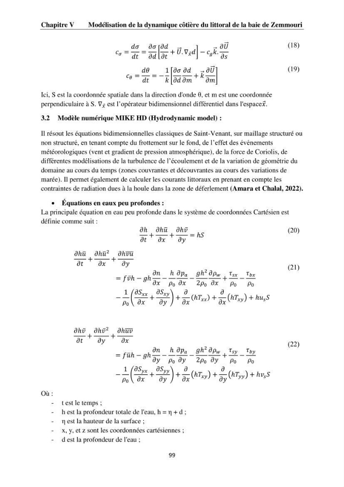
Ici, S est la coordonnée spatiale dans la direction d'onde θ, et m est une coordonnée
perpendiculaire à S. ∇ í µí±¥ est l’opérateur bidimensionnel différentiel dans l'espaceí µí±¥ .
3.2 Modèle numérique MIKE HD (Hydrodynamic model) :
Il résout les équations bidimensionnelles classiques de Saint-Venant, sur maillage structuré ou
non structuré, en tenant compte du frottement sur le fond, de l’effet des événements
météorologiques (vent et gradient de pression atmosphérique), de la force de Coriolis, de
différentes modélisations de la turbulence de l’écoulement et de la variation de géométrie du
domaine au cours du temps (zones couvrantes et découvrantes au cours des variations de
marée). Il permet également de calculer les courants littoraux en prenant en compte les
contraintes de radiation dues à la houle dans la zone de déferlement (Amara et Chalal, 2022).
Équations en eaux peu profondes :
La principale équation en eau peu profonde dans le système de coordonnées Cartésien est
définie comme suit :
í µí¼ℎ
í µí¼í µí+
í µí¼ℎí µí±¢ ̅
í µí¼í µí±¥
+
í µí¼ℎí µí±£̅
í µí¼í µí±¦
= ℎí µí±
(20)
í µí¼ℎí µí±¢ ̅
í µí¼í µí+
í µí¼ℎí µí±¢ ̅
2
í µí¼í µí±¥
+
í µí¼ℎí µí±£í µí±¢ ̅̅̅̅
í µí¼í µí±¦
= í µí±í µí±£̅ ℎ − í µí±ℎ
í µí¼í µí±
í µí¼í µí±¥
−
ℎ
í µí¼ 0
í µí¼í µí± í µí±
í µí¼í µí±¥
−
í µí±ℎ
2
2í µí¼ 0
í µí¼í µí¼ í µí±¤
í µí¼í µí±¥
+
í µí¼ í µí± í µí±¥
í µí¼ 0
−
í µí¼ í µí±í µí±¥
í µí¼ 0
−
1
í µí¼ 0
(
í µí¼í µí± í µí±¥í µí±¥
í µí¼í µí±¥
+
í µí¼í µí± í µí±¥í µí±¦
í µí¼í µí±¦
) +
í µí¼
í µí¼í µí±¥
(ℎí µí± í µí±¥í µí±¥ ) +
í µí¼
í µí¼í µí±¥
(ℎí µí± í µí±¥í µí±¦ ) + ℎí µí±¢ í µí± í µí±
(21)
í µí¼ℎí µí±£̅
í µí¼í µí+
í µí¼ℎí µí±£̅
2
í µí¼í µí±¦
+
í µí¼ℎí µí±¢í µí±£ ̅̅̅̅
í µí¼í µí±¥
= í µí±í µí±¢ ̅ℎ − í µí±ℎ
í µí¼í µí±
í µí¼í µí±¦
−
ℎ
í µí¼ 0
í µí¼í µí± í µí±
í µí¼í µí±¦
−
í µí±ℎ
2
2í µí¼ 0
í µí¼í µí¼ í µí±¤
í µí¼í µí±¦
+
í µí¼ í µí± í µí±¦
í µí¼ 0
−
í µí¼ í µí±í µí±¦
í µí¼ 0
−
1
í µí¼ 0
(
í µí¼í µí± í µí±¦í µí±¥
í µí¼í µí±¥
+
í µí¼í µí± í µí±¦í µí±¦
í µí¼í µí±¦
) +
í µí¼
í µí¼í µí±¥
(ℎí µí± í µí±¥í µí±¦ ) +
í µí¼
í µí¼í µí±¦
(ℎí µí± í µí±¦í µí±¦ ) + ℎí µí±£ í µí± í µí±
(22)
Où :
- t est le temps ;
- h est la profondeur totale de l'eau, h = η + d ;
- η est la hauteur de la surface ;
- x, y, et z sont les coordonnées cartésiennes ;
- d est la profondeur de l'eau ;
Modélisation de la dynamique côtière du littoral de la baie de Zemmouri
99
í µí± í µí¼ =
í µí±í µí¼
í µí±í µí=
í µí¼í µí¼
í µí¼í µí±
[
í µí¼í µí±
í µí¼í µí+ í µí± ⃗ ⃗ . ∇ í µí±¥ í µí±] − í µí± í µí± í µí± ⃗ .
í µí¼í µí± ⃗ ⃗
í µí¼í µí±
(18)
í µí± í µí¼ =
í µí±í µí¼
í µí±í µí= −
1
í µí±
[
í µí¼í µí¼
í µí¼í µí±
í µí¼í µí±
í µí¼í µí±
+ í µí± ⃗
í µí¼í µí± ⃗ ⃗
í µí¼í µí±
]
(19)
Ici, S est la coordonnée spatiale dans la direction d'onde θ, et m est une coordonnée
perpendiculaire à S. ∇ í µí±¥ est l’opérateur bidimensionnel différentiel dans l'espaceí µí±¥ .
3.2 Modèle numérique MIKE HD (Hydrodynamic model) :
Il résout les équations bidimensionnelles classiques de Saint-Venant, sur maillage structuré ou
non structuré, en tenant compte du frottement sur le fond, de l’effet des événements
météorologiques (vent et gradient de pression atmosphérique), de la force de Coriolis, de
différentes modélisations de la turbulence de l’écoulement et de la variation de géométrie du
domaine au cours du temps (zones couvrantes et découvrantes au cours des variations de
marée). Il permet également de calculer les courants littoraux en prenant en compte les
contraintes de radiation dues à la houle dans la zone de déferlement (Amara et Chalal, 2022).
Équations en eaux peu profondes :
La principale équation en eau peu profonde dans le système de coordonnées Cartésien est
définie comme suit :
í µí¼ℎ
í µí¼í µí+
í µí¼ℎí µí±¢ ̅
í µí¼í µí±¥
+
í µí¼ℎí µí±£̅
í µí¼í µí±¦
= ℎí µí±
(20)
í µí¼ℎí µí±¢ ̅
í µí¼í µí+
í µí¼ℎí µí±¢ ̅
2
í µí¼í µí±¥
+
í µí¼ℎí µí±£í µí±¢ ̅̅̅̅
í µí¼í µí±¦
= í µí±í µí±£̅ ℎ − í µí±ℎ
í µí¼í µí±
í µí¼í µí±¥
−
ℎ
í µí¼ 0
í µí¼í µí± í µí±
í µí¼í µí±¥
−
í µí±ℎ
2
2í µí¼ 0
í µí¼í µí¼ í µí±¤
í µí¼í µí±¥
+
í µí¼ í µí± í µí±¥
í µí¼ 0
−
í µí¼ í µí±í µí±¥
í µí¼ 0
−
1
í µí¼ 0
(
í µí¼í µí± í µí±¥í µí±¥
í µí¼í µí±¥
+
í µí¼í µí± í µí±¥í µí±¦
í µí¼í µí±¦
) +
í µí¼
í µí¼í µí±¥
(ℎí µí± í µí±¥í µí±¥ ) +
í µí¼
í µí¼í µí±¥
(ℎí µí± í µí±¥í µí±¦ ) + ℎí µí±¢ í µí± í µí±
(21)
í µí¼ℎí µí±£̅
í µí¼í µí+
í µí¼ℎí µí±£̅
2
í µí¼í µí±¦
+
í µí¼ℎí µí±¢í µí±£ ̅̅̅̅
í µí¼í µí±¥
= í µí±í µí±¢ ̅ℎ − í µí±ℎ
í µí¼í µí±
í µí¼í µí±¦
−
ℎ
í µí¼ 0
í µí¼í µí± í µí±
í µí¼í µí±¦
−
í µí±ℎ
2
2í µí¼ 0
í µí¼í µí¼ í µí±¤
í µí¼í µí±¦
+
í µí¼ í µí± í µí±¦
í µí¼ 0
−
í µí¼ í µí±í µí±¦
í µí¼ 0
−
1
í µí¼ 0
(
í µí¼í µí± í µí±¦í µí±¥
í µí¼í µí±¥
+
í µí¼í µí± í µí±¦í µí±¦
í µí¼í µí±¦
) +
í µí¼
í µí¼í µí±¥
(ℎí µí± í µí±¥í µí±¦ ) +
í µí¼
í µí¼í µí±¦
(ℎí µí± í µí±¦í µí±¦ ) + ℎí µí±£ í µí± í µí±
(22)
Où :
- t est le temps ;
- h est la profondeur totale de l'eau, h = η + d ;
- η est la hauteur de la surface ;
- x, y, et z sont les coordonnées cartésiennes ;
- d est la profondeur de l'eau ;