

39
coloured rocks. The deeper sections encountered permafrost and digging below this
was difficult because of the tough ground conditions.
The frozen ground did reveal finer constituents like sand, silt, minor clay along
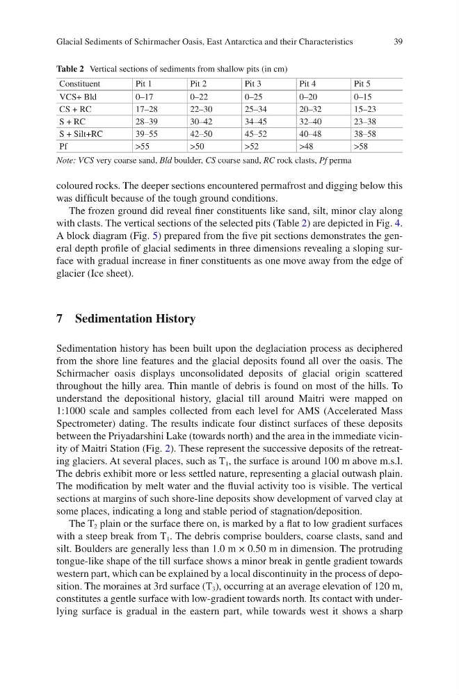
with clasts. The vertical sections of the selected pits (Table 2) are depicted in Fig. 4.
A block diagram (Fig. 5) prepared from the five pit sections demonstrates the general depth profile of glacial sediments in three dimensions revealing a sloping surface with gradual increase in finer constituents as one move away from the edge of
glacier (Ice sheet).
7 Sedimentation History
Sedimentation history has been built upon the deglaciation process as deciphered
from the shore line features and the glacial deposits found all over the oasis. The
Schirmacher oasis displays unconsolidated deposits of glacial origin scattered
throughout the hilly area. Thin mantle of debris is found on most of the hills. To
understand the depositional history, glacial till around Maitri were mapped on
1:1000 scale and samples collected from each level for AMS (Accelerated Mass
Spectrometer) dating. The results indicate four distinct surfaces of these deposits
between the Priyadarshini Lake (towards north) and the area in the immediate vicinity of Maitri Station (Fig. 2). These represent the successive deposits of the retreating glaciers. At several places, such as T 1 , the surface is around 100 m above m.s.l.
The debris exhibit more or less settled nature, representing a glacial outwash plain.
The modification by melt water and the fluvial activity too is visible. The vertical
sections at margins of such shore-line deposits show development of varved clay at
some places, indicating a long and stable period of stagnation/deposition.
The T 2 plain or the surface there on, is marked by a flat to low gradient surfaces
with a steep break from T 1 . The debris comprise boulders, coarse clasts, sand and
silt. Boulders are generally less than 1.0 m × 0.50 m in dimension. The protruding
tongue-like shape of the till surface shows a minor break in gentle gradient towards
western part, which can be explained by a local discontinuity in the process of deposition. The moraines at 3rd surface (T 3 ), occurring at an average elevation of 120 m,
constitutes a gentle surface with low-gradient towards north. Its contact with underlying surface is gradual in the eastern part, while towards west it shows a sharp
Table 2 Vertical sections of sediments from shallow pits (in cm)
Constituent
Pit 1
Pit 2
Pit 3
Pit 4
Pit 5
VCS+ Bld
0–17
0–22
0–25
0–20
0–15
CS + RC
17–28
22–30
25–34
20–32
15–23
S + RC
28–39
30–42
34–45
32–40
23–38
S + Silt+RC
39–55
42–50
45–52
40–48
38–58
Pf
>55
>50
>52
>48
>58
Note: VCS very coarse sand, Bld boulder, CS coarse sand, RC rock clasts, Pf perma
Glacial Sediments of Schirmacher Oasis, East Antarctica and their Characteristics
coloured rocks. The deeper sections encountered permafrost and digging below this
was difficult because of the tough ground conditions.
The frozen ground did reveal finer constituents like sand, silt, minor clay along
with clasts. The vertical sections of the selected pits (Table 2) are depicted in Fig. 4.
A block diagram (Fig. 5) prepared from the five pit sections demonstrates the general depth profile of glacial sediments in three dimensions revealing a sloping surface with gradual increase in finer constituents as one move away from the edge of
glacier (Ice sheet).
7 Sedimentation History
Sedimentation history has been built upon the deglaciation process as deciphered
from the shore line features and the glacial deposits found all over the oasis. The
Schirmacher oasis displays unconsolidated deposits of glacial origin scattered
throughout the hilly area. Thin mantle of debris is found on most of the hills. To
understand the depositional history, glacial till around Maitri were mapped on
1:1000 scale and samples collected from each level for AMS (Accelerated Mass
Spectrometer) dating. The results indicate four distinct surfaces of these deposits
between the Priyadarshini Lake (towards north) and the area in the immediate vicinity of Maitri Station (Fig. 2). These represent the successive deposits of the retreating glaciers. At several places, such as T 1 , the surface is around 100 m above m.s.l.
The debris exhibit more or less settled nature, representing a glacial outwash plain.
The modification by melt water and the fluvial activity too is visible. The vertical
sections at margins of such shore-line deposits show development of varved clay at
some places, indicating a long and stable period of stagnation/deposition.
The T 2 plain or the surface there on, is marked by a flat to low gradient surfaces
with a steep break from T 1 . The debris comprise boulders, coarse clasts, sand and
silt. Boulders are generally less than 1.0 m × 0.50 m in dimension. The protruding
tongue-like shape of the till surface shows a minor break in gentle gradient towards
western part, which can be explained by a local discontinuity in the process of deposition. The moraines at 3rd surface (T 3 ), occurring at an average elevation of 120 m,
constitutes a gentle surface with low-gradient towards north. Its contact with underlying surface is gradual in the eastern part, while towards west it shows a sharp
Table 2 Vertical sections of sediments from shallow pits (in cm)
Constituent
Pit 1
Pit 2
Pit 3
Pit 4
Pit 5
VCS+ Bld
0–17
0–22
0–25
0–20
0–15
CS + RC
17–28
22–30
25–34
20–32
15–23
S + RC
28–39
30–42
34–45
32–40
23–38
S + Silt+RC
39–55
42–50
45–52
40–48
38–58
Pf
>55
>50
>52
>48
>58
Note: VCS very coarse sand, Bld boulder, CS coarse sand, RC rock clasts, Pf perma
Glacial Sediments of Schirmacher Oasis, East Antarctica and their Characteristics